
FCCInfo.com
A Service of Cavell, Mertz & Associates, Inc.
(855) FCC-INFO
|
|
KSXF-LD from 03/16/1999 KSXF-LD from 03/01/1999 KSXF-LD from 01/31/1994 KSXF-LD from 10/20/1993 |
|
|
|||||||||||||||||
|
|
Status: License Application Accepted: 10/31/2000 License Expires: 04/01/2022 File Number: BLTT-20001020ABR Prefix Type: This is a license for a UHF translator FCC Website Links: LMS Facility Details This Application Other KSXF-LD Applications Including Superseded Applications Mailing Address Correspondence for KSXF-LD Correspondence related to application BLTT-20001020ABR Service Contour - Open Street Map or USGS Map (74 dBu) Service Contour - KML / Google Earth (74 dBu) Rabbit Ears Info Search for KSXF-LD Site Location: 43-33-14.0 N 96-41-06.0 W (NAD 83) Site Location: 43-33-14.1 N 96-41-04.8 W (Converted to NAD 27) ERP: 10.1 kW Polarization: Horizontally polarized R/C AGL: 57 m (187 ft.) R/C AMSL: 499 m (1637 ft.) Calculated Site Elevation: 442 m. (1450 ft.) Height Overall*: 0 m (* As Filed In This Application, may differ from ASR Data, Below.) Directional Antenna - Antenna Make/Model: Andrew AL8 Antenna ID: 16352 Polarization: Horizontally polarized
| |||||||||||||||||||
| Antenna Data for Antenna Id: 16352 KSXF-LD TX File: BLTT-20001020ABR Andrew - AL8 Service: TX Standard Pattern: Y Pattern and Field Values Include a 270° Clockwise Rotation | 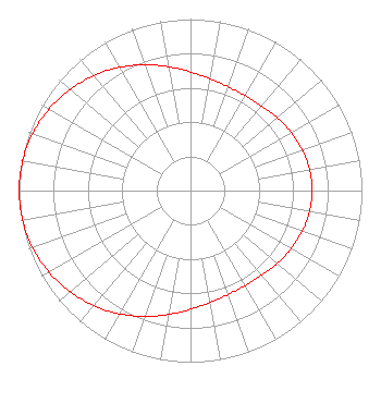 | |||||||||||||||||||
| Azimuth | Ratio | Azimuth | Ratio | Azimuth | Ratio | Azimuth | Ratio | |||||||||||||
| 0 | 0.692 | 10 | 0.662 | 20 | 0.644 | 30 | 0.639 | |||||||||||||
| 40 | 0.646 | 50 | 0.661 | 60 | 0.678 | 70 | 0.694 | |||||||||||||
| 80 | 0.705 | 90 | 0.709 | 100 | 0.705 | 110 | 0.694 | |||||||||||||
| 120 | 0.678 | 130 | 0.661 | 140 | 0.646 | 150 | 0.639 | |||||||||||||
| 160 | 0.644 | 170 | 0.662 | 180 | 0.692 | 190 | 0.733 | |||||||||||||
| 200 | 0.780 | 210 | 0.829 | 220 | 0.876 | 230 | 0.918 | |||||||||||||
| 240 | 0.953 | 250 | 0.979 | 260 | 0.995 | 270 | 1.000 | |||||||||||||
| 280 | 0.995 | 290 | 0.979 | 300 | 0.953 | 310 | 0.918 | |||||||||||||
| 320 | 0.876 | 330 | 0.829 | 340 | 0.780 | 350 | 0.733 | |||||||||||||
Structure Registration Number 1050703 [ASR Heights Differ from KSXF-LD Application] Structure Type: TOWER Registered To: FRIESSEN, WARREN DBA = FRIESSEN CONSTRUCTION Structure Address: Jct Hwy 11 & E 6th St. Sioux Falls, SD County Name: Minnehaha County ASR Issued: 06/19/1998 Date Built: 02/13/1990 Site Elevation: 441.9 m (1450 ft.) Structure Height: 60.4 m (198 ft.) Height Overall: 60.4 m (198 ft.) Overall Height AMSL: 502.3 m (1648 ft.) FAA Determination: 02/26/1990 FAA Study #: 89-AGL-2023-OE FAA Circular #: Paint & Light FAA Chapters: NONE 43-33-14.0 N 96-41-06.0 W (NAD 83) 43-33-14.1 N 96-41-04.8 W (Converted to NAD 27) |
Chattanooga, TN 37401 Phone: 423-468-5100 Limited Liability Company | Date: 10/31/2000 Application Certifier TCCSA D/B/A TRINITY BROADCASTING NETWORK, INC. P.o. Box C-11949 Santa Ana, CA 92711 Applicant COLBY M. MAY COLBY M. MAY Colby M. May, Attorney At Law | ||||||||||||||||||