
FCCInfo.com
A Service of Cavell, Mertz & Associates, Inc.
(855) FCC-INFO
|
|
KION-TV from 02/23/1997 KION-TV from 10/04/1993 |
Virtual Channel 46 |
|
||||||||||||||||||||||||||||
|
|
Repacking Information: No changes Status: License Application Accepted: 06/04/2003 License Expires: 12/01/2022 File Number: BLCDT-20030604ACO Prefix Type: This is a License for a commercial digital TV station FCC Website Links: LMS Facility Details This Application Other KION-TV Applications Including Superseded Applications Mailing Address Correspondence for KION-TV Correspondence related to application BLCDT-20030604ACO Service Contour - Open Street Map or USGS Map (41 dBu) Service Contour - KML / Google Earth (41 dBu) Public Inspection Files History Cards for KION-TV Rabbit Ears Info Search for KION-TV Site Location: 36-32-05.0 N 121-37-18.0 W (NAD 83) Site Location: 36-32-05.1 N 121-37-14.2 W (Converted to NAD 27) ERP: 46 kW Polarization: Horizontally polarized HAAT: 758 m (2487 ft.) Electrical Beam Tilt: 1.5 degrees R/C AGL: 49 m (161 ft.) R/C AMSL: 1082 m (3550 ft.) Site Elevation: 1033 m. (3389 ft.) Height Overall*: 69 m (226 ft.) (* As Filed In This Application, may differ from ASR Data, Below.) Directional Antenna - Antenna Make/Model: Andrew ALP12L6-HSM-32 Antenna ID: 44481 Polarization: Horizontally polarized | ||||||||||||||||||||||||||||||
| Antenna Data for Antenna Id: 44481 KION-TV DT File: BLCDT-20030604ACO Andrew - ALP12L6-HSM-32 Service: DT Standard Pattern: Y Pattern and Field Values Include a 310° Clockwise Rotation | 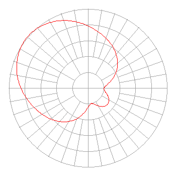 | ||||||||||||||||||||||||||||||
| Azimuth | Ratio | Azimuth | Ratio | Azimuth | Ratio | Azimuth | Ratio | ||||||||||||||||||||||||
| 0 | 0.784 | 10 | 0.723 | 20 | 0.667 | 30 | 0.612 | ||||||||||||||||||||||||
| 40 | 0.553 | 50 | 0.488 | 60 | 0.414 | 70 | 0.327 | ||||||||||||||||||||||||
| 80 | 0.246 | 90 | 0.203 | 100 | 0.215 | 110 | 0.261 | ||||||||||||||||||||||||
| 120 | 0.305 | 130 | 0.322 | 140 | 0.305 | 150 | 0.261 | ||||||||||||||||||||||||
| 160 | 0.215 | 170 | 0.203 | 180 | 0.246 | 190 | 0.327 | ||||||||||||||||||||||||
| 200 | 0.414 | 210 | 0.488 | 220 | 0.553 | 230 | 0.612 | ||||||||||||||||||||||||
| 240 | 0.667 | 250 | 0.723 | 260 | 0.784 | 270 | 0.848 | ||||||||||||||||||||||||
| 280 | 0.907 | 290 | 0.954 | 300 | 0.988 | 310 | 1.000 | ||||||||||||||||||||||||
| 320 | 0.988 | 330 | 0.954 | 340 | 0.907 | 350 | 0.848 | ||||||||||||||||||||||||
Structure Registration Number 1015714 Structure Type: TOWER Registered To: NPG OF MONTEREY-SALINAS CA, LLC Structure Address: Mount Toro Monterey, CA County Name: Monterey County ASR Issued: 04/25/2014 Date Built: 10/01/1968 Site Elevation: 1033.3 m (3390 ft.) Structure Height: 68.9 m (226 ft.) Height Overall: 68.9 m (226 ft.) Overall Height AMSL: 1102.2 m (3616 ft.) FAA Determination: 03/03/1976 FAA Study #: SFO-OE-68-111 Paint & Light FAA Chapters: 1, 3, 11, 21 36-32-05.0 N 121-37-18.0 W (NAD 83) 36-32-05.1 N 121-37-14.2 W (Converted to NAD 27) |
825 Edmond Street Saint Joseph, MO 64501 Phone: 816-271-8652 Limited Liability Company | Date: 06/04/2003 Application Certifier ACKERLEY MEDIA GROUP, INC. 2625 S. Memorial Drive Suite B Tulsa, OK 74129 Applicant KENT TEGTMEIER 1550 Moffett Street Salinas, CA 93905 CHIEF ENGINEER, KION-TV JOHN M. BURGETT Wiley Rein & Fielding Llp 1776 K Street, Nw Washington, DC 20006 | |||||||||||||||||||||||||||||
| |||||||||||||||||||||||||||||||