
FCCInfo.com
A Service of Cavell, Mertz & Associates, Inc.
(855) FCC-INFO
|
|
K31FD-D from 07/13/1999 K31FD-D from 06/18/1998 K31FD-D from 10/08/1998 |
|
|
||||||||||||||||
|
|
Repacking Information: No changes Status: License Application Accepted: 10/02/2014 License Expires: 10/01/2022 File Number: BLDTA-20141002AAF Prefix Type: This is BLDTA FCC Website Links: LMS Facility Details This Application Other K31FD-D Applications Including Superseded Applications Mailing Address Correspondence for K31FD-D Correspondence related to application BLDTA-20141002AAF Service Contour - Open Street Map or USGS Map (51 dBu) Service Contour - KML / Google Earth (51 dBu) Public Inspection Files Rabbit Ears Info Search for K31FD-D Site Location: 43-45-18.0 N 116-05-55.0 W (NAD 83) Site Location: 43-45-18.4 N 116-05-51.6 W (Converted to NAD 27) ERP: 15 kW R/C AGL: 25 m (82 ft.) R/C AMSL: m Emission Mask: Simple Site Elevation: 2145 m. (7037 ft.) Height Overall*: 79.2 m (260 ft.) (* As Filed In This Application, may differ from ASR Data, Below.) Directional Antenna - Antenna Make/Model: Jampro JUHDX6 Antenna ID: 94509 | ||||||||||||||||||
| Antenna Data for Antenna Id: 94509 K31FD-D DC File: BLDTA-20141002AAF Jampro - JUHDX6 Service: DC Standard Pattern: Y Pattern and Field Values Include a 242° Clockwise Rotation | 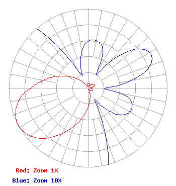 | ||||||||||||||||||
| Azimuth | Ratio | Azimuth | Ratio | Azimuth | Ratio | Azimuth | Ratio | ||||||||||||
| 2 | 0.060 | 12 | 0.060 | 22 | 0.050 | 32 | 0.020 | ||||||||||||
| 42 | 0.050 | 52 | 0.080 | 62 | 0.090 | 72 | 0.080 | ||||||||||||
| 82 | 0.050 | 92 | 0.020 | 102 | 0.050 | 112 | 0.060 | ||||||||||||
| 122 | 0.060 | 132 | 0.050 | 142 | 0.030 | 152 | 0.020 | ||||||||||||
| 162 | 0.080 | 172 | 0.160 | 182 | 0.270 | 192 | 0.400 | ||||||||||||
| 202 | 0.540 | 212 | 0.700 | 222 | 0.860 | 232 | 0.960 | ||||||||||||
| 242 | 1.000 | 252 | 0.960 | 262 | 0.860 | 272 | 0.690 | ||||||||||||
| 282 | 0.540 | 292 | 0.400 | 302 | 0.270 | 312 | 0.160 | ||||||||||||
| 322 | 0.080 | 332 | 0.020 | 342 | 0.030 | 352 | 0.050 | ||||||||||||
Structure Registration Number 1053967 [ASR Heights Differ from K31FD-D Application] Structure Type: TOWER Registered To: SUTRO CORPORATION Structure Address: Deer Point 10.75 Mi Nne Boise, ID County Name: Boise County ASR Issued: 08/03/1998 Date Built: 09/01/1975 Site Elevation: 2145.8 m (7040 ft.) Structure Height: 67 m (220 ft.) Height Overall: 79.2 m (260 ft.) Overall Height AMSL: 2225 m (7300 ft.) FAA Determination: 05/30/1997 FAA Study #: 97-ANM-0651-OE FAA Circular #: 70/7460-1J Paint & Light FAA Chapters: 3, 4, 5, 13 Removed expiration date from determination. Scenario 1./jjs/case#635066 43-45-18.0 N 116-05-55.0 W (NAD 83) 43-45-18.4 N 116-05-51.6 W (Converted to NAD 27) |
295 Madison Avenue, 12th Floor New York, NY 10017 Phone: 954-606-5486 Corporation | Date: 10/02/2014 Application Certifier THREE ANGELS BROADCASTING NETWORK, INC. P O Box 220 West Frankfort, IL 62896-0220 Applicant DANIEL N. PEEK Po Box 220 West Frankfort, IL 62896-0220 ENGINEER MOSES PRIMO 3abn | |||||||||||||||||