
FCCInfo.com
A Service of Cavell, Mertz & Associates, Inc.
(855) FCC-INFO
|
|
K48KJ-D from 04/09/2007 K48KJ-D from 10/23/2006 K48KJ-D from 03/15/2004 |
|
|
||||||||||||||||
|
|
Status: License (Licensed And Silent) Application Accepted: 10/23/2013 License Expires: 04/01/2022 File Number: BLDTL-20131023ACE Prefix Type: This is BLDTL FCC Website Links: LMS Facility Details This Application Other K48KJ-D Applications Including Superseded Applications Mailing Address Correspondence for K48KJ-D Correspondence related to application BLDTL-20131023ACE Service Contour - Open Street Map or USGS Map (51 dBu) Service Contour - KML / Google Earth (51 dBu) Rabbit Ears Info Search for K48KJ-D Site Location: 44-02-43.9 N 93-23-02.7 W (NAD 83) Site Location: 44-02-44.0 N 93-23-01.9 W (Converted to NAD 27) ERP: 4.92 kW R/C AGL: 180 m (591 ft.) R/C AMSL: 527.5 m (1731 ft.) Emission Mask: Stringent Site Elevation: 347.5 m. (1140 ft.) Height Overall*: 209.4 m (687 ft.) (* As Filed In This Application, may differ from ASR Data, Below.) Directional Antenna - Antenna Make/Model: Jampro JA/LS-AL-8 Antenna ID: 19378 | ||||||||||||||||||
| Antenna Data for Antenna Id: 19378 K48KJ-D LD File: BLDTL-20131023ACE Jampro - JA/LS-AL-8 Service: LD Standard Pattern: Y | 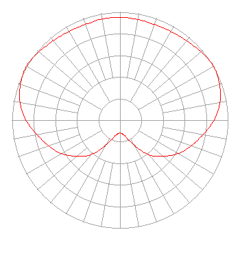 | ||||||||||||||||||
| Azimuth | Ratio | Azimuth | Ratio | Azimuth | Ratio | Azimuth | Ratio | ||||||||||||
| 0 | 0.950 | 10 | 0.945 | 20 | 0.940 | 30 | 0.945 | ||||||||||||
| 40 | 0.960 | 50 | 0.980 | 60 | 1.000 | 70 | 0.980 | ||||||||||||
| 80 | 0.940 | 90 | 0.870 | 100 | 0.780 | 110 | 0.700 | ||||||||||||
| 120 | 0.620 | 130 | 0.520 | 140 | 0.420 | 150 | 0.270 | ||||||||||||
| 160 | 0.170 | 170 | 0.130 | 180 | 0.120 | 190 | 0.130 | ||||||||||||
| 200 | 0.170 | 210 | 0.270 | 220 | 0.420 | 230 | 0.520 | ||||||||||||
| 240 | 0.620 | 250 | 0.700 | 260 | 0.780 | 270 | 0.870 | ||||||||||||
| 280 | 0.940 | 290 | 0.980 | 300 | 1.000 | 310 | 0.980 | ||||||||||||
| 320 | 0.960 | 330 | 0.945 | 340 | 0.940 | 350 | 0.950 | ||||||||||||
Structure Registration Number 1030901 [ASR Heights Differ from K48KJ-D Application] Structure Type: TOWER Registered To: BLOOMING PRAIRIE FARM RADIO INC = KOWZ-FM + KRUE Structure Address: 2 Mi S Of Meriden Nr Waseca, MN County Name: Steele County ASR Issued: 05/27/2011 Date Built: 01/01/1994 Site Elevation: 347.4 m (1140 ft.) Structure Height: 209.4 m (687 ft.) Height Overall: 210.3 m (690 ft.) Overall Height AMSL: 557.7 m (1830 ft.) FAA Determination: 05/26/2011 FAA Study #: 2011-AGL-2683-OE FAA Circular #: 70/7460-1H Paint & Light FAA Chapters: 3, 4, 5, 13 PRIOR STUDY 1994-AGL-2032-OE 44-02-43.9 N 93-23-02.7 W (NAD 83) 44-02-44.0 N 93-23-01.9 W (Converted to NAD 27) |
Hurst, TX 76054 Phone: 214-770-7770 Corporation | Date: 10/23/2013 Application Certifier THREE ANGELS BROADCASTING NETWORK, INC. P O Box 220 West Frankfort, IL 62896-0220 Applicant DANIEL N. PEEK Po Box 220 West Frankfort, IL 62896-0220 ENGINEER MOSES PRIMO 3abn | |||||||||||||||||