
FCCInfo.com
A Service of Cavell, Mertz & Associates, Inc.
(855) FCC-INFO
|
|
K14IO-D from 09/17/1992 |
|
|
||||||||||||||||
|
|
Status: License Application Accepted: 12/13/2013 License Expires: 04/01/2022 File Number: BLDTL-20131213AAM Prefix Type: This is BLDTL FCC Website Links: LMS Facility Details This Application Other K14IO-D Applications Including Superseded Applications Mailing Address Correspondence for K14IO-D Correspondence related to application BLDTL-20131213AAM Service Contour - Open Street Map or USGS Map (51 dBu) Service Contour - KML / Google Earth (51 dBu) Rabbit Ears Info Search for K14IO-D Site Location: 44-18-42.0 N 100-21-10.0 W (NAD 83) Site Location: 44-18-42.1 N 100-21-08.5 W (Converted to NAD 27) ERP: 1.6 kW R/C AGL: 40 m (131 ft.) R/C AMSL: 570.4 m (1871 ft.) Emission Mask: Stringent Site Elevation: 530.4 m. (1740 ft.) Height Overall*: 139.2 m (457 ft.) (* As Filed In This Application, may differ from ASR Data, Below.) Directional Antenna - Antenna Make/Model: Alan Dick & Company Ltd. T14H1-1BB5S1 Antenna ID: 108691 | ||||||||||||||||||
| Antenna Data for Antenna Id: 108691 K14IO-D LD File: BLDTL-20131213AAM Alan Dick & Company Ltd. - T14H1-1BB5S1 Service: LD Standard Pattern: Y | 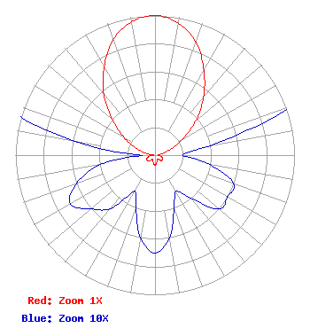 | ||||||||||||||||||
| Azimuth | Ratio | Azimuth | Ratio | Azimuth | Ratio | Azimuth | Ratio | ||||||||||||
| 0 | 1.000 | 10 | 0.960 | 20 | 0.860 | 30 | 0.700 | ||||||||||||
| 40 | 0.540 | 50 | 0.380 | 60 | 0.230 | 70 | 0.110 | ||||||||||||
| 80 | 0.040 | 90 | 0.020 | 100 | 0.040 | 110 | 0.060 | ||||||||||||
| 120 | 0.060 | 130 | 0.060 | 140 | 0.040 | 150 | 0.030 | ||||||||||||
| 160 | 0.040 | 170 | 0.060 | 180 | 0.070 | 190 | 0.060 | ||||||||||||
| 200 | 0.040 | 210 | 0.030 | 220 | 0.050 | 230 | 0.060 | ||||||||||||
| 240 | 0.070 | 250 | 0.060 | 260 | 0.040 | 270 | 0.010 | ||||||||||||
| 280 | 0.060 | 290 | 0.140 | 300 | 0.260 | 310 | 0.400 | ||||||||||||
| 320 | 0.570 | 330 | 0.730 | 340 | 0.880 | 350 | 0.970 | ||||||||||||
Structure Registration Number 1042183 [ASR Heights Differ from K14IO-D Application] Structure Type: GTOWER Registered To: Riverfront Broadcasting, LLC Structure Address: Cedar Hill Rd Fort Pierre, SD County Name: Stanley County ASR Issued: 10/30/2013 Date Built: 01/01/1994 Site Elevation: 530.3 m (1740 ft.) Structure Height: 152.1 m (499 ft.) Height Overall: 152.1 m (499 ft.) Overall Height AMSL: 682.4 m (2239 ft.) FAA Determination: 09/04/2013 FAA Study #: 2013-AGL-7385-OE FAA Circular #: 70/7460-1K Paint & Light FAA Chapters: 4, 6, 12 PRIOR STUDY 2013-AGL-3766-OE 44-18-42.0 N 100-21-10.0 W (NAD 83) 44-18-42.1 N 100-21-08.5 W (Converted to NAD 27) |
4370 Peachtree Road, Ne Atlanta, GA 30319 Phone: 404-504-9828 Applicant | Date: 12/13/2013 Application Certifier INDEPENDENT COMMUNICATIONS, INC. 2817 West 11th. Street Sioux Falls,, SD 57104-2540 Applicant JOHN BENNETT 2817 W. 11th. Street Sioux Falls, SD 57104-2450 CHIEF ENGINEER JOHN BENNETT Independent Communications, Inc. | |||||||||||||||||