
FCCInfo.com
A Service of Cavell, Mertz & Associates, Inc.
(855) FCC-INFO
|
|
KTKB-LD from 02/16/2004 KTKB-LD from 09/03/2003 |
|
|
||||||||||||||||
|
|
Status: License Application Accepted: 07/14/2010 License Expires: 02/01/2023 File Number: BLDTL-20100714AAP Prefix Type: This is BLDTL FCC Website Links: LMS Facility Details This Application Other KTKB-LD Applications Including Superseded Applications Mailing Address Correspondence for KTKB-LD Correspondence related to application BLDTL-20100714AAP Service Contour - Open Street Map or USGS Map (51 dBu) Service Contour - KML / Google Earth (51 dBu) Rabbit Ears Info Search for KTKB-LD Site Location: 13-29-15.9 N 144-49-36.2 E (NAD 83) ERP: 1.4 kW Electrical Beam Tilt: 0.5 degrees R/C AGL: 42 m (138 ft.) R/C AMSL: 243 m (797 ft.) Emission Mask: Stringent Site Elevation: 201 m. (659 ft.) Height Overall*: 45 m (148 ft.) (* As Filed In This Application, may differ from ASR Data, Below.) Directional Antenna - Antenna Make/Model: Andrew ALP8M2-HSP-26-CUS Antenna ID: 97271 | ||||||||||||||||||
| Antenna Data for Antenna Id: 97271 KTKB-LD LD File: BLDTL-20100714AAP Andrew - ALP8M2-HSP-26-CUS Service: LD Standard Pattern: Y | 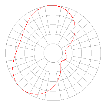 | ||||||||||||||||||
| Azimuth | Ratio | Azimuth | Ratio | Azimuth | Ratio | Azimuth | Ratio | ||||||||||||
| 0 | 1.000 | 10 | 0.974 | 20 | 0.919 | 30 | 0.833 | ||||||||||||
| 40 | 0.717 | 50 | 0.585 | 60 | 0.446 | 70 | 0.326 | ||||||||||||
| 80 | 0.259 | 90 | 0.259 | 100 | 0.289 | 110 | 0.305 | ||||||||||||
| 120 | 0.289 | 130 | 0.259 | 140 | 0.259 | 150 | 0.326 | ||||||||||||
| 160 | 0.446 | 170 | 0.585 | 180 | 0.717 | 190 | 0.833 | ||||||||||||
| 200 | 0.919 | 210 | 0.974 | 220 | 1.000 | 230 | 0.993 | ||||||||||||
| 240 | 0.955 | 250 | 0.899 | 260 | 0.836 | 270 | 0.778 | ||||||||||||
| 280 | 0.739 | 290 | 0.729 | 300 | 0.739 | 310 | 0.778 | ||||||||||||
| 320 | 0.836 | 330 | 0.899 | 340 | 0.955 | 350 | 0.993 | ||||||||||||
Structure Registration Number 1236658 Structure Type: TOWER Registered To: KM Broadcasting of Guam, LLC Structure Address: Mt. Barrigada, Lot 10-4, Block D, Tract 9 Barrigada, GU ASR Issued: 08/30/2011 Date Built: 08/29/2006 Site Elevation: 200.9 m (659 ft.) Structure Height: 44.2 m (145 ft.) Height Overall: 45.1 m (148 ft.) Overall Height AMSL: 246 m (807 ft.) FAA Determination: 10/27/2003 FAA Study #: 2003-AWP-3412-OE FAA Circular #: 70/7460-1K Paint & Light FAA Chapters: 3, 4, 5, 12 OM&L to remain the same as prior study = PAINT/RED LIGHTS 13-29-15.9 N 144-49-36.2 E (NAD 83) |
3654 West Jarvis Ave Skokie, IL 60076 Phone: 202-293-0567 Limited Liability Company | Date: 07/14/2010 Application Certifier KM BROADCASTING OF GUAM, L.L.C. 3654 West Jarvis Avenue Skokie, IL 60076 Applicant ED Y. LEE 238 Archbishop Flores Strett Agana, GU 96910 CONSULTING ENGINEER AARON P. SHAINIS, ESQ. Shainis & Peltzman, Chartered | |||||||||||||||||