
FCCInfo.com
A Service of Cavell, Mertz & Associates, Inc.
(855) FCC-INFO
|
|
|
|
|
||||||||||||||||
|
|
Status: License Application Accepted: 01/22/2010 License Expires: 10/01/2022 File Number: BLDTL-20100122ACV Prefix Type: This is BLDTL FCC Website Links: LMS Facility Details This Application Other K33IX-D Applications Including Superseded Applications Mailing Address Correspondence for K33IX-D Correspondence related to application BLDTL-20100122ACV Service Contour - Open Street Map or USGS Map (51 dBu) Service Contour - KML / Google Earth (51 dBu) Rabbit Ears Info Search for K33IX-D Site Location: 41-29-50.0 N 109-20-38.0 W (NAD 83) Site Location: 41-29-50.1 N 109-20-35.5 W (Converted to NAD 27) ERP: 0.5 kW R/C AGL: 9 m (30 ft.) R/C AMSL: 2338 m (7671 ft.) Emission Mask: Simple Site Elevation: 2329 m. (7641 ft.) Height Overall*: 55 m (180 ft.) (* As Filed In This Application, may differ from ASR Data, Below.) Directional Antenna - Antenna Make/Model: Aldena ATU.08.07.420 ARRAY Antenna ID: 94737 | ||||||||||||||||||
| Antenna Data for Antenna Id: 94737 K33IX-D LD File: BLDTL-20100122ACV Aldena - ATU.08.07.420 ARRAY Service: LD Standard Pattern: Y Pattern and Field Values Include a 315° Clockwise Rotation | 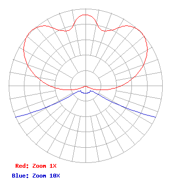 | ||||||||||||||||||
| Azimuth | Ratio | Azimuth | Ratio | Azimuth | Ratio | Azimuth | Ratio | ||||||||||||
| 5 | 0.902 | 15 | 0.756 | 25 | 0.793 | 35 | 0.947 | ||||||||||||
| 45 | 1.000 | 55 | 0.967 | 65 | 0.872 | 75 | 0.729 | ||||||||||||
| 85 | 0.556 | 95 | 0.378 | 105 | 0.218 | 115 | 0.094 | ||||||||||||
| 125 | 0.021 | 135 | 0.010 | 145 | 0.010 | 155 | 0.010 | ||||||||||||
| 165 | 0.010 | 175 | 0.010 | 185 | 0.010 | 195 | 0.010 | ||||||||||||
| 205 | 0.010 | 215 | 0.010 | 225 | 0.010 | 235 | 0.021 | ||||||||||||
| 245 | 0.094 | 255 | 0.218 | 265 | 0.378 | 275 | 0.556 | ||||||||||||
| 285 | 0.729 | 295 | 0.872 | 305 | 0.967 | 315 | 1.000 | ||||||||||||
| 325 | 0.947 | 335 | 0.793 | 345 | 0.756 | 355 | 0.902 | ||||||||||||
Structure Registration Number 1010026 Structure Type: TOWER Registered To: Wagonwheel Communications Corporation Structure Address: Atop Wilkins Peak Rock Springs, WY County Name: Sweetwater County ASR Issued: 02/05/2007 Date Built: 01/01/1994 Site Elevation: 2328.7 m (7640 ft.) Structure Height: 54.9 m (180 ft.) Height Overall: 54.9 m (180 ft.) Overall Height AMSL: 2383.6 m (7820 ft.) Paint & Light FAA Chapters: None 41-29-50.0 N 109-20-38.0 W (NAD 83) 41-29-50.1 N 109-20-35.5 W (Converted to NAD 27) |
Hurst, TX 76054 Phone: 214-770-7770 Corporation | Date: 01/22/2010 Application Certifier EICB-TV EAST, LLC 406 Copeland Drive Cedar Hill, TX 75104 Applicant B. W. ST. CLAIR 2355 Ranch Drive Westminster, CO 80234 ENGINEERING CONSULTANT DR. RANDY WEISS Eicb-tv East, Llc | |||||||||||||||||