
FCCInfo.com
A Service of Cavell, Mertz & Associates, Inc.
(855) FCC-INFO
|
|
WYCU-LD from 05/17/2011 |
|
|
|||||||||||||||||
|
|
Status: License Application Accepted: 12/14/2012 License Expires: 04/01/2023 File Number: BLDTL-20121214ABJ Prefix Type: This is BLDTL FCC Website Links: LMS Facility Details This Application Other WYCU-LD Applications Including Superseded Applications Mailing Address Correspondence for WYCU-LD Correspondence related to application BLDTL-20121214ABJ Service Contour - Open Street Map or USGS Map (51 dBu) Service Contour - KML / Google Earth (51 dBu) Rabbit Ears Info Search for WYCU-LD Site Location: 43-23-46.0 N 72-17-51.0 W (NAD 83) Site Location: 43-23-45.7 N 72-17-52.7 W (Converted to NAD 27) ERP: 9.6 kW R/C AGL: 26.8 m (88 ft.) R/C AMSL: 621.1 m (2038 ft.) Emission Mask: Full Service Site Elevation: 594.3 m. (1950 ft.) Height Overall*: 30.4 m (100 ft.) (* As Filed In This Application, may differ from ASR Data, Below.) Directional Antenna - Antenna Make/Model: Antenna Concepts Inc. ACB12CR Antenna ID: 17626
| |||||||||||||||||||
| Antenna Data for Antenna Id: 17626 WYCU-LD LD File: BLDTL-20121214ABJ Antenna Concepts Inc. - ACB12CR Service: LD Standard Pattern: Y Pattern and Field Values Include a 214° Clockwise Rotation | 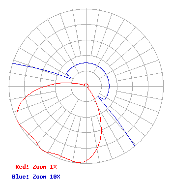 | |||||||||||||||||||
| Azimuth | Ratio | Azimuth | Ratio | Azimuth | Ratio | Azimuth | Ratio | |||||||||||||
| 4 | 0.030 | 14 | 0.030 | 24 | 0.030 | 34 | 0.030 | |||||||||||||
| 44 | 0.030 | 54 | 0.030 | 64 | 0.030 | 74 | 0.030 | |||||||||||||
| 84 | 0.030 | 94 | 0.030 | 104 | 0.030 | 114 | 0.030 | |||||||||||||
| 124 | 0.030 | 134 | 0.030 | 144 | 0.150 | 154 | 0.400 | |||||||||||||
| 164 | 0.690 | 174 | 0.890 | 184 | 0.990 | 194 | 0.970 | |||||||||||||
| 204 | 0.960 | 214 | 1.000 | 224 | 0.960 | 234 | 0.970 | |||||||||||||
| 244 | 0.990 | 254 | 0.890 | 264 | 0.690 | 274 | 0.400 | |||||||||||||
| 284 | 0.150 | 294 | 0.030 | 304 | 0.030 | 314 | 0.030 | |||||||||||||
| 324 | 0.030 | 334 | 0.030 | 344 | 0.030 | 354 | 0.030 | |||||||||||||
Structure Registration Number 1280942 [ASR Heights Differ from WYCU-LD Application] Structure Type: GTOWER Registered To: American Towers LLC Structure Address: Cat Hole Rd (green Mountain) Claremont, NH County Name: Sullivan County ASR Issued: 01/05/2021 Date Built: 01/01/1992 Site Elevation: 594.3 m (1950 ft.) Structure Height: 30.4 m (100 ft.) Height Overall: 30.8 m (101 ft.) Overall Height AMSL: 625.1 m (2051 ft.) FAA Determination: 09/21/2011 FAA Study #: 2011-ANE-1493-OE Paint & Light FAA Chapters: NONE 43-23-46.0 N 72-17-51.0 W (NAD 83) 43-23-45.7 N 72-17-52.7 W (Converted to NAD 27) |
4370 Peachtree Road, Ne Atlanta, GA 30319 Phone: 404-504-9828 Limited Liability Company | Date: 12/14/2012 Application Certifier CROSS HILL COMMUNICATIONS, LLC 75 Newport Rd. Suite 210 New London, NH 03257-5467 Applicant DANIEL N. CARBONARA 1300 Putney Rd. Brattleboro, VT 05301-9063 STATION MANAGER PETER TANNENWALD Fletcher, Heald & Hildreth, P.l.c. | ||||||||||||||||||