
FCCInfo.com
A Service of Cavell, Mertz & Associates, Inc.
(855) FCC-INFO
|
|
|
Virtual Channel 18 |
|
|||||||||||||||||||||||||||||||
|
|
Repacking Information: No changes Status: License Application Accepted: 03/03/2009 License Expires: 08/01/2022 File Number: BLCDT-20090303ACS Prefix Type: This is a License for a commercial digital TV station FCC Website Links: LMS Facility Details This Application Other KJTL Applications Including Superseded Applications Mailing Address Correspondence for KJTL Correspondence related to application BLCDT-20090303ACS Service Contour - Open Street Map or USGS Map (41 dBu) Service Contour - KML / Google Earth (41 dBu) Public Inspection Files Rabbit Ears Info Search for KJTL Site Location: 34-12-05.0 N 98-43-46.0 W (NAD 83) Site Location: 34-12-04.7 N 98-43-44.8 W (Converted to NAD 27) ERP: 1000 kW Polarization: Horizontally polarized HAAT: 263 m (863 ft.) Electrical Beam Tilt: 0.75 degrees R/C AGL: 253.9 m (833 ft.) R/C AMSL: 591.6 m (1941 ft.) Site Elevation: 337.7 m. (1108 ft.) Height Overall*: 327 m (1073 ft.) (* As Filed In This Application, may differ from ASR Data, Below.) Directional Antenna - Antenna Make/Model: DIELECTRIC TFU-29JSC-R 3T180 Antenna ID: 78511 Polarization: Horizontally polarized
| |||||||||||||||||||||||||||||||||
| Antenna Data for Antenna Id: 78511 KJTL DT File: BLCDT-20090303ACS DIELECTRIC - TFU-29JSC-R 3T180 Service: DT Standard Pattern: Y | 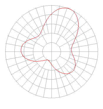 | |||||||||||||||||||||||||||||||||
| Azimuth | Ratio | Azimuth | Ratio | Azimuth | Ratio | Azimuth | Ratio | |||||||||||||||||||||||||||
| 0 | 0.809 | 10 | 0.932 | 20 | 0.994 | 23 | 1.000 | |||||||||||||||||||||||||||
| 30 | 0.978 | 40 | 0.885 | 50 | 0.748 | 60 | 0.606 | |||||||||||||||||||||||||||
| 70 | 0.497 | 80 | 0.440 | 90 | 0.433 | 100 | 0.468 | |||||||||||||||||||||||||||
| 110 | 0.531 | 120 | 0.595 | 130 | 0.625 | 140 | 0.609 | |||||||||||||||||||||||||||
| 143 | 0.595 | 150 | 0.546 | 160 | 0.456 | 170 | 0.361 | |||||||||||||||||||||||||||
| 180 | 0.279 | 190 | 0.224 | 200 | 0.203 | 210 | 0.210 | |||||||||||||||||||||||||||
| 220 | 0.249 | 230 | 0.320 | 240 | 0.418 | 250 | 0.521 | |||||||||||||||||||||||||||
| 260 | 0.609 | 263 | 0.629 | 270 | 0.656 | 280 | 0.650 | |||||||||||||||||||||||||||
| 290 | 0.597 | 300 | 0.524 | 310 | 0.462 | 320 | 0.441 | |||||||||||||||||||||||||||
| 330 | 0.466 | 340 | 0.541 | 350 | 0.665 | |||||||||||||||||||||||||||||
Structure Registration Number 1050255 Structure Type: GTOWER Registered To: Mission Broadcasting, Inc. Structure Address: 0.16 Mi Se Of N2380 Rd And E1940 Rd Intersection. Grandfield, OK County Name: Tillman County ASR Issued: 09/26/2023 Date Built: 09/26/2023 Site Elevation: 337.7 m (1108 ft.) Structure Height: 304.9 m (1000 ft.) Height Overall: 327.1 m (1073 ft.) Overall Height AMSL: 664.8 m (2181 ft.) FAA Determination: 01/12/2023 FAA Study #: 2022-ASW-19532-OE FAA Circular #: 70/7460-1G Paint & Light FAA Chapters: 3, 4, 5, 9 PRIOR STUDY 1998-ASW-1311-OE 34-12-05.8 N 98-43-45.9 W (NAD 83) 34-12-05.5 N 98-43-44.7 W (Converted to NAD 27) |
4822 Kemp Boulevard Suite 300 Wichita Falls, TX 76308 Phone: 940-228-7861 Corporation | Date: 03/03/2009 Application Certifier MISSION BROADCASTING, INC. 544 Red Rock Drive Wadsworth, OH 44281 Applicant MARTIN R. DOCZKAT Cohen, Dippell And Everist, P.c. 1300 L Street Nw, Suite 1100 Washington, DC 20005 CONSULTING ENGINEER HOWARD LIBERMAN Drinker Biddle & Reath Llp 1500 K Street, Nw Suite 1100 Washington, DC 20005 | ||||||||||||||||||||||||||||||||
|
| |||||||||||||||||||||||||||||||||