
FCCInfo.com
A Service of Cavell, Mertz & Associates, Inc.
(855) FCC-INFO
|
|
K18NT-D from 08/17/2005 |
|
|
||||||||||||||||
|
|
Status: License Application Accepted: 11/01/2005 License Expires: 04/01/2022 File Number: BLTTL-20051101ABL Prefix Type: This is a license for a UHF LPTV station FCC Website Links: LMS Facility Details This Application Other K18NT-D Applications Including Superseded Applications Mailing Address Correspondence for K18NT-D Correspondence related to application BLTTL-20051101ABL Service Contour - Open Street Map or USGS Map (74 dBu) Service Contour - KML / Google Earth (74 dBu) Rabbit Ears Info Search for K18NT-D Site Location: 47-57-52.0 N 97-01-47.0 W (NAD 83) Site Location: 47-57-52.1 N 97-01-45.7 W (Converted to NAD 27) ERP: 9.4 kW R/C AGL: 97.5 m (320 ft.) R/C AMSL: 350.5 m (1150 ft.) Site Elevation: 253 m. (830 ft.) Height Overall*: 152.1 m (499 ft.) (* As Filed In This Application, may differ from ASR Data, Below.) Directional Antenna - Antenna Make/Model: Jampro JA/LS-OM-8 Antenna ID: 19585 | ||||||||||||||||||
| Antenna Data for Antenna Id: 19585 K18NT-D TX File: BLTTL-20051101ABL Jampro - JA/LS-OM-8 Service: TX Standard Pattern: Y | 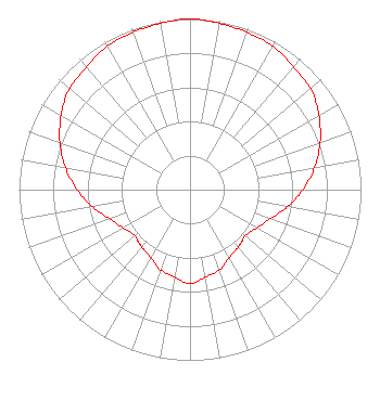 | ||||||||||||||||||
| Azimuth | Ratio | Azimuth | Ratio | Azimuth | Ratio | Azimuth | Ratio | ||||||||||||
| 0 | 1.000 | 10 | 0.990 | 20 | 0.980 | 30 | 0.970 | ||||||||||||
| 40 | 0.940 | 45 | 0.930 | 50 | 0.920 | 60 | 0.870 | ||||||||||||
| 70 | 0.810 | 80 | 0.740 | 90 | 0.660 | 100 | 0.580 | ||||||||||||
| 110 | 0.500 | 120 | 0.450 | 130 | 0.420 | 135 | 0.430 | ||||||||||||
| 140 | 0.440 | 150 | 0.460 | 160 | 0.500 | 170 | 0.520 | ||||||||||||
| 180 | 0.550 | 190 | 0.520 | 200 | 0.500 | 210 | 0.460 | ||||||||||||
| 220 | 0.440 | 225 | 0.430 | 230 | 0.420 | 240 | 0.450 | ||||||||||||
| 250 | 0.500 | 260 | 0.580 | 270 | 0.660 | 280 | 0.740 | ||||||||||||
| 290 | 0.810 | 300 | 0.870 | 310 | 0.920 | 315 | 0.930 | ||||||||||||
| 320 | 0.940 | 330 | 0.970 | 340 | 0.980 | 350 | 0.990 | ||||||||||||
Structure Registration Number 1034780 [ASR Heights Differ from K18NT-D Application] Structure Type: GTOWER Registered To: Vertical Bridge CC FM, LLC Structure Address: 2 Mi N East Grand Forks, MN County Name: Polk County ASR Issued: 11/08/2018 Date Built: 01/01/1997 Site Elevation: 253 m (830 ft.) Structure Height: 151.1 m (496 ft.) Height Overall: 154.2 m (506 ft.) Overall Height AMSL: 407.2 m (1336 ft.) FAA Determination: 10/08/2015 FAA Study #: 2015-AGL-10218-OE FAA Circular #: 70/7460-1J Paint & Light FAA Chapters: 3, 4, 5, 13 PRIOR STUDY 1997-AGL-3364-OE 47-57-52.2 N 97-01-46.8 W (NAD 83) 47-57-52.3 N 97-01-45.5 W (Converted to NAD 27) |
Hurst, TX 76054 Phone: 214-770-7770 Corporation | Date: 11/01/2005 Application Certifier THREE ANGELS BROADCASTING NETWORK, INC. Po Box 220 3391 Charley Good Road West Frankfort, IL 62896 Applicant DANIEL N. PEEK Po Box 220 West Frankfort, IL 62896-0220 ENGINEER MOSES PRIMO 3abn | |||||||||||||||||