
FCCInfo.com
A Service of Cavell, Mertz & Associates, Inc.
(855) FCC-INFO
|
|
|
|
|
||||||||||||||||
|
|
Status: License Application Accepted: 05/19/2009 License Expires: 10/01/2022 File Number: BLDTT-20090519ACU Prefix Type: This is BLDTT FCC Website Links: LMS Facility Details This Application Other K28JU-D Applications Including Superseded Applications Mailing Address Correspondence for K28JU-D Correspondence related to application BLDTT-20090519ACU Service Contour - Open Street Map or USGS Map (51 dBu) Service Contour - KML / Google Earth (51 dBu) Rabbit Ears Info Search for K28JU-D Site Location: 41-34-43.0 N 109-19-14.0 W (NAD 83) Site Location: 41-34-43.1 N 109-19-11.5 W (Converted to NAD 27) ERP: 0.5 kW R/C AGL: 99 m (325 ft.) R/C AMSL: 2421 m (7943 ft.) Emission Mask: Simple Site Elevation: 2322 m. (7618 ft.) Height Overall*: 122 m (400 ft.) (* As Filed In This Application, may differ from ASR Data, Below.) Directional Antenna - Antenna Make/Model: Andrew AL8W Antenna ID: 16357
| ||||||||||||||||||
| Antenna Data for Antenna Id: 16357 K28JU-D LD File: BLDTT-20090519ACU Andrew - AL8W Service: LD Standard Pattern: Y Pattern and Field Values Include a 180° Clockwise Rotation | 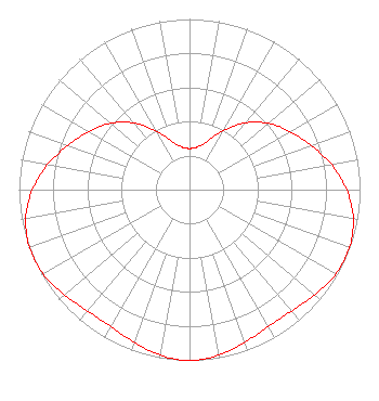 | ||||||||||||||||||
| Azimuth | Ratio | Azimuth | Ratio | Azimuth | Ratio | Azimuth | Ratio | ||||||||||||
| 0 | 0.241 | 10 | 0.253 | 20 | 0.302 | 30 | 0.397 | ||||||||||||
| 40 | 0.510 | 50 | 0.605 | 60 | 0.680 | 70 | 0.758 | ||||||||||||
| 80 | 0.845 | 90 | 0.922 | 100 | 0.975 | 110 | 0.997 | ||||||||||||
| 120 | 0.990 | 130 | 0.959 | 140 | 0.929 | 150 | 0.925 | ||||||||||||
| 160 | 0.951 | 170 | 0.985 | 180 | 1.000 | 190 | 0.985 | ||||||||||||
| 200 | 0.951 | 210 | 0.925 | 220 | 0.929 | 230 | 0.959 | ||||||||||||
| 240 | 0.990 | 250 | 0.997 | 260 | 0.975 | 270 | 0.922 | ||||||||||||
| 280 | 0.845 | 290 | 0.758 | 300 | 0.680 | 310 | 0.605 | ||||||||||||
| 320 | 0.510 | 330 | 0.397 | 340 | 0.302 | 350 | 0.253 | ||||||||||||
Structure Registration Number 1009408 Structure Type: TOWER Registered To: SWEETWATER TELEVISION CO INC Structure Address: White Mountain 8.21 Km W Rock Springs, WY County Name: Sweetwater County ASR Issued: 02/21/1997 Date Built: 01/01/1956 Site Elevation: 2322 m (7618 ft.) Structure Height: 122 m (400 ft.) Height Overall: 122 m (400 ft.) Overall Height AMSL: 2444 m (8018 ft.) FAA Determination: 04/02/1980 FAA Study #: 80-RM-142-OE Paint & Light FAA Chapters: 1, 3, 12, 21 RED LIGHTS/PAINT 41-34-43.0 N 109-19-14.0 W (NAD 83) 41-34-43.1 N 109-19-11.5 W (Converted to NAD 27) |
2660 Peck Ave Riverton, WY 82501 Applicant | Date: 05/19/2009 Application Certifier CENTRAL WYOMING COLLEGE 2660 Peck Ave Riverton, WY 82501 Applicant BOB SPAIN Central Wyoming College Wyoptv ROBERT SPAIN 2660 Peck Avenue Riverton, WY 82501 DIRECTOR OF ENGINEERING | |||||||||||||||||