
FCCInfo.com
A Service of Cavell, Mertz & Associates, Inc.
(855) FCC-INFO
|
|
K17HI-D from 04/10/2006 |
|
|
||||||||||||||||
|
|
Status: License Application Accepted: 04/01/2009 License Expires: 08/01/2022 File Number: BLDTL-20090401ABY Prefix Type: This is BLDTL FCC Website Links: LMS Facility Details This Application Other K17HI-D Applications Including Superseded Applications Mailing Address Correspondence for K17HI-D Correspondence related to application BLDTL-20090401ABY Service Contour - Open Street Map or USGS Map (51 dBu) Service Contour - KML / Google Earth (51 dBu) Rabbit Ears Info Search for K17HI-D Site Location: 35-14-31.4 N 101-48-44.7 W (NAD 83) Site Location: 35-14-31.2 N 101-48-43.0 W (Converted to NAD 27) ERP: 1.5 kW R/C AGL: 100 m (328 ft.) R/C AMSL: 1205 m (3953 ft.) Emission Mask: Stringent Site Elevation: 1105 m. (3625 ft.) Height Overall*: 159.1 m (522 ft.) (* As Filed In This Application, may differ from ASR Data, Below.) Directional Antenna - Antenna Make/Model: Jampro JA/LS-BC-4 Antenna ID: 19411 | ||||||||||||||||||
| Antenna Data for Antenna Id: 19411 K17HI-D LD File: BLDTL-20090401ABY Jampro - JA/LS-BC-4 Service: LD Standard Pattern: Y Pattern and Field Values Include a 220° Clockwise Rotation | 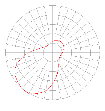 | ||||||||||||||||||
| Azimuth | Ratio | Azimuth | Ratio | Azimuth | Ratio | Azimuth | Ratio | ||||||||||||
| 0 | 0.230 | 10 | 0.260 | 20 | 0.270 | 30 | 0.280 | ||||||||||||
| 40 | 0.290 | 50 | 0.280 | 60 | 0.270 | 70 | 0.260 | ||||||||||||
| 80 | 0.230 | 90 | 0.210 | 100 | 0.190 | 110 | 0.180 | ||||||||||||
| 120 | 0.180 | 130 | 0.190 | 140 | 0.220 | 150 | 0.270 | ||||||||||||
| 160 | 0.350 | 170 | 0.500 | 180 | 0.660 | 190 | 0.820 | ||||||||||||
| 200 | 0.920 | 210 | 1.000 | 220 | 1.000 | 230 | 0.960 | ||||||||||||
| 240 | 0.920 | 250 | 0.820 | 260 | 0.660 | 270 | 0.500 | ||||||||||||
| 280 | 0.350 | 290 | 0.270 | 300 | 0.220 | 310 | 0.190 | ||||||||||||
| 320 | 0.180 | 330 | 0.180 | 340 | 0.190 | 350 | 0.210 | ||||||||||||
Structure Registration Number 1053477 Structure Type: GTOWER Registered To: Global Tower, LLC. through American Towers, LLC Structure Address: 2800 Echo Drive (374463) Amarillo, TX County Name: Potter County ASR Issued: 02/26/2018 Date Built: 07/18/2000 Site Elevation: 1105.2 m (3626 ft.) Structure Height: 152.7 m (501 ft.) Height Overall: 159.1 m (522 ft.) Overall Height AMSL: 1264.3 m (4148 ft.) FAA Determination: 02/13/2018 FAA Study #: 2018-ASW-1663-OE FAA Circular #: 70/7460-1L Paint & Light FAA Chapters: 4, 8, 12 PRIOR STUDY 2014-ASW-622-OE 35-14-31.4 N 101-48-44.7 W (NAD 83) 35-14-31.2 N 101-48-43.0 W (Converted to NAD 27) |
Hurst, TX 76054-4025 Phone: 214-770-7770 Corporation | Date: 04/01/2009 Application Certifier THREE ANGELS BROADCASTING NETWORK, INC. P O Box 220 West Frankfort, IL 62896-0220 Applicant DANIEL N. PEEK P.o. Box 220 West Frankfort, IL 62896-0220 ENGINEER MOSES PRIMO 3abn | |||||||||||||||||