
FCCInfo.com
A Service of Cavell, Mertz & Associates, Inc.
(855) FCC-INFO
|
|
KGHD-LD from 03/16/2010 KGHD-LD from 02/04/2002 |
|
|
||||||||||||||||
|
|
Status: License Application Accepted: 09/04/2013 License Expires: 10/01/2022 File Number: BLTVL-20130904ABP Prefix Type: This is a license for a VHF LPTV station FCC Website Links: LMS Facility Details This Application Other KGHD-LD Applications Including Superseded Applications Mailing Address Correspondence for KGHD-LD Correspondence related to application BLTVL-20130904ABP Service Contour - Open Street Map or USGS Map (62 dBu) Service Contour - KML / Google Earth (62 dBu) Rabbit Ears Info Search for KGHD-LD Site Location: 35-56-46.0 N 115-02-37.0 W (NAD 83) Site Location: 35-56-46.1 N 115-02-34.0 W (Converted to NAD 27) ERP: 0.999 kW R/C AGL: 38 m (125 ft.) R/C AMSL: 1355 m (4446 ft.) Site Elevation: 1317 m. (4321 ft.) Height Overall*: 83.5 m (274 ft.) (* As Filed In This Application, may differ from ASR Data, Below.) Directional Antenna - Antenna Make/Model: Scala CL-46 Antenna ID: 115372 | ||||||||||||||||||
| Antenna Data for Antenna Id: 115372 KGHD-LD TX File: BLTVL-20130904ABP Scala - CL-46 Service: TX Standard Pattern: Y Pattern and Field Values Include a 340° Clockwise Rotation | 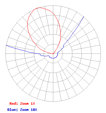 | ||||||||||||||||||
| Azimuth | Ratio | Azimuth | Ratio | Azimuth | Ratio | Azimuth | Ratio | ||||||||||||
| 0 | 0.835 | 10 | 0.655 | 20 | 0.460 | 30 | 0.295 | ||||||||||||
| 40 | 0.105 | 50 | 0.035 | 60 | 0.025 | 70 | 0.015 | ||||||||||||
| 80 | 0.010 | 90 | 0.010 | 100 | 0.010 | 110 | 0.010 | ||||||||||||
| 120 | 0.010 | 130 | 0.010 | 140 | 0.010 | 150 | 0.010 | ||||||||||||
| 160 | 0.010 | 170 | 0.010 | 180 | 0.010 | 190 | 0.010 | ||||||||||||
| 200 | 0.010 | 210 | 0.010 | 220 | 0.010 | 230 | 0.010 | ||||||||||||
| 240 | 0.010 | 250 | 0.015 | 260 | 0.025 | 270 | 0.035 | ||||||||||||
| 280 | 0.105 | 290 | 0.295 | 300 | 0.460 | 310 | 0.655 | ||||||||||||
| 320 | 0.835 | 330 | 0.940 | 340 | 1.000 | 350 | 0.940 | ||||||||||||
Structure Registration Number 1020486 Structure Type: TOWER Registered To: KUPN Licensee, LLC Structure Address: 7-a Black Mountain Rd Black Mtn Arden Site Henderson, NV County Name: Clark County ASR Issued: 01/11/2017 Date Built: 03/01/1989 Site Elevation: 1316.7 m (4320 ft.) Structure Height: 81.4 m (267 ft.) Height Overall: 83.5 m (274 ft.) Overall Height AMSL: 1400.2 m (4594 ft.) FAA Determination: 04/18/1997 FAA Study #: 97-AWP-0697-OE Paint & Light FAA Chapters: NONE ADJACENT TO EXISTING STRUCTURES WHICH ARE MARKED & LIGHTED. LCS 35-56-46.0 N 115-02-37.0 W (NAD 83) 35-56-46.1 N 115-02-34.0 W (Converted to NAD 27) |
Victorville, CA 92392 Phone: 760-956-2111 Individual | Date: 09/04/2013 Application Certifier OBIDIA PORRAS 12601 El Dorado Place Victorville, CA 92392 Applicant RAFAEL PORRAS 12601 El Dorado Place Victorville, CA 92392 TECHNICAL CONSULTANT SHELLEY SADOWSKY, ESQUIRE Sciarrino & Shubert, Pllc | |||||||||||||||||
