
FCCInfo.com
A Service of Cavell, Mertz & Associates, Inc.
(855) FCC-INFO
|
|
|
|
|
||||||||||||||||
|
|
Status: License Application Accepted: 03/25/2011 License Expires: 10/01/2022 File Number: BLDTT-20110325AAL Prefix Type: This is BLDTT FCC Website Links: LMS Facility Details This Application Other K16JE-D Applications Including Superseded Applications Mailing Address Correspondence for K16JE-D Correspondence related to application BLDTT-20110325AAL Service Contour - Open Street Map or USGS Map (51 dBu) Service Contour - KML / Google Earth (51 dBu) Rabbit Ears Info Search for K16JE-D Site Location: 42-55-36.6 N 115-21-13.2 W (NAD 83) Site Location: 42-55-37.0 N 115-21-09.9 W (Converted to NAD 27) ERP: 0.43 kW R/C AGL: 9 m (30 ft.) R/C AMSL: 898.7 m (2948 ft.) Emission Mask: Stringent Site Elevation: 889.7 m. (2919 ft.) Height Overall*: 10 m (33 ft.) (* As Filed In This Application, may differ from ASR Data, Below.) Directional Antenna - Antenna Make/Model: R.F. Systems LPR4SK Antenna ID: 104062
| ||||||||||||||||||
| Antenna Data for Antenna Id: 104062 K16JE-D LD File: BLDTT-20110325AAL R.F. Systems - LPR4SK Service: LD Standard Pattern: Y Pattern and Field Values Include a 60° Clockwise Rotation | 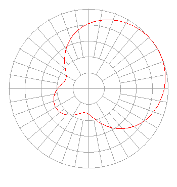 | ||||||||||||||||||
| Azimuth | Ratio | Azimuth | Ratio | Azimuth | Ratio | Azimuth | Ratio | ||||||||||||
| 0 | 0.813 | 10 | 0.868 | 20 | 0.914 | 30 | 0.950 | ||||||||||||
| 40 | 0.976 | 50 | 0.994 | 60 | 1.000 | 70 | 0.994 | ||||||||||||
| 80 | 0.976 | 90 | 0.950 | 100 | 0.914 | 110 | 0.868 | ||||||||||||
| 120 | 0.813 | 130 | 0.743 | 140 | 0.659 | 150 | 0.565 | ||||||||||||
| 160 | 0.467 | 170 | 0.380 | 180 | 0.322 | 190 | 0.309 | ||||||||||||
| 200 | 0.337 | 210 | 0.386 | 220 | 0.433 | 230 | 0.465 | ||||||||||||
| 240 | 0.476 | 250 | 0.465 | 260 | 0.433 | 270 | 0.386 | ||||||||||||
| 280 | 0.337 | 290 | 0.309 | 300 | 0.322 | 310 | 0.380 | ||||||||||||
| 320 | 0.467 | 330 | 0.565 | 340 | 0.659 | 350 | 0.743 | ||||||||||||
Structure Registration Number 1277841 Structure Type: POLE Registered To: King Broadcasting Company Structure Address: Near Glenns Ferry, Idaho Glenns Ferry, ID County Name: Elmore County ASR Issued: 02/13/2019 Date Built: 02/26/2011 Site Elevation: 889.7 m (2919 ft.) Structure Height: 10 m (33 ft.) Height Overall: 10 m (33 ft.) Overall Height AMSL: 899.7 m (2952 ft.) FAA Determination: 12/08/2010 FAA Study #: 2010-ANM-2221-OE Paint & Light FAA Chapters: NONE 42-55-36.6 N 115-21-13.2 W (NAD 83) 42-55-37.0 N 115-21-09.9 W (Converted to NAD 27) |
Tegna, Inc. 8350 Broad Street, Suite 2000 Tysons, VA 22102 Phone: 703-873-6606 Corporation | Date: 03/25/2011 Application Certifier KING BROADCASTING COMPANY King Broadcasting Company 400 South Record Street Dallas, TX 75202 Applicant JOHN M. BURGETT Wiley Rein Llp PAUL BUDELL 5407 Fairview Avenue Boise, ID 83706 DIRECTOR OF TECHNOLOGY | |||||||||||||||||