
FCCInfo.com
A Service of Cavell, Mertz & Associates, Inc.
(855) FCC-INFO
|
|
K11FF-D from 05/27/2009 K11FF-D from 10/14/2004 |
|
|
||||||||||||||||
|
|
Status: License Application Accepted: 09/03/2014 License Expires: 04/01/2022 File Number: BLDTV-20140903AHQ Prefix Type: This is BLDTV FCC Website Links: LMS Facility Details This Application Other K11FF-D Applications Including Superseded Applications Mailing Address Correspondence for K11FF-D Correspondence related to application BLDTV-20140903AHQ Service Contour - Open Street Map or USGS Map (48 dBu) Service Contour - KML / Google Earth (48 dBu) Rabbit Ears Info Search for K11FF-D Site Location: 47-10-30.0 N 114-55-03.7 W (NAD 83) Site Location: 47-10-30.3 N 114-55-00.2 W (Converted to NAD 27) ERP: 0.005 kW R/C AGL: 8.5 m (28 ft.) R/C AMSL: 1231.5 m (4040 ft.) Emission Mask: Simple Site Elevation: 1223 m. (4012 ft.) Height Overall*: 9.1 m (30 ft.) (* As Filed In This Application, may differ from ASR Data, Below.) Directional Antenna - Antenna Make/Model: Scala HDCA-5-2HW Antenna ID: 118003
| ||||||||||||||||||
| Antenna Data for Antenna Id: 118003 K11FF-D LD File: BLDTV-20140903AHQ Scala - HDCA-5-2HW Service: LD Standard Pattern: Y Pattern and Field Values Include a 35° Clockwise Rotation | 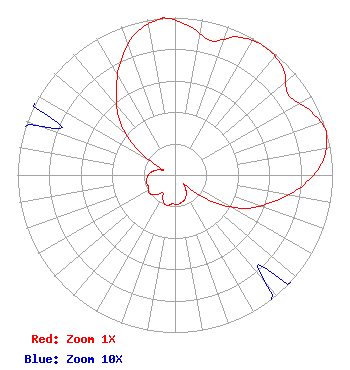 | ||||||||||||||||||
| Azimuth | Ratio | Azimuth | Ratio | Azimuth | Ratio | Azimuth | Ratio | ||||||||||||
| 5 | 0.954 | 15 | 0.883 | 25 | 0.966 | 35 | 0.993 | ||||||||||||
| 45 | 0.966 | 55 | 0.883 | 65 | 0.954 | 74 | 1.000 | ||||||||||||
| 75 | 0.996 | 85 | 0.938 | 95 | 0.810 | 105 | 0.647 | ||||||||||||
| 115 | 0.500 | 125 | 0.304 | 135 | 0.089 | 145 | 0.122 | ||||||||||||
| 155 | 0.159 | 165 | 0.177 | 175 | 0.187 | 185 | 0.184 | ||||||||||||
| 195 | 0.200 | 205 | 0.179 | 215 | 0.137 | 225 | 0.179 | ||||||||||||
| 235 | 0.200 | 245 | 0.184 | 255 | 0.187 | 265 | 0.177 | ||||||||||||
| 275 | 0.159 | 285 | 0.122 | 295 | 0.089 | 305 | 0.304 | ||||||||||||
| 315 | 0.500 | 325 | 0.647 | 335 | 0.810 | 345 | 0.938 | ||||||||||||
| 355 | 0.996 | 356 | 1.000 | ||||||||||||||||
Structure Registration Number 1288130 Structure Type: GTOWER Registered To: Superior TV Translator District Structure Address: Thompson Peak Superior, MT County Name: Mineral County ASR Issued: 09/14/2018 Date Built: 08/15/2019 Site Elevation: 1223 m (4012 ft.) Structure Height: 9.1 m (30 ft.) Height Overall: 9.1 m (30 ft.) Overall Height AMSL: 1232.1 m (4042 ft.) FAA Determination: 12/03/2012 FAA Study #: 2012-ANM-2934-OE Paint & Light FAA Chapters: NONE 47-10-30.0 N 114-55-03.7 W (NAD 83) 47-10-30.3 N 114-55-00.2 W (Converted to NAD 27) |
P.o. Box 250 Superior, MT 59872 Applicant | Date: 09/03/2014 Application Certifier SUPERIOR TV TRANSLATOR DISTRICT P.o. Box 550 Superior, MT 59872 Applicant JOHN R. BARNETT 13806 E. 22nd Lane Spokane Valley, WA 99216 CONSULTING ENGINEER JOHN R. BARNETT Bps,llc. | |||||||||||||||||