
FCCInfo.com
A Service of Cavell, Mertz & Associates, Inc.
(855) FCC-INFO
|
|
WYIN from 02/04/1987 WYIN from 01/18/1987 |
Virtual Channel 56 |  |
|
|||||||||||||||||||||
|
|
Repacking Information: No changes Status: License Application Accepted: 02/06/2004 License Expires: 08/01/2021 File Number: BLEDT-20040206AAA Prefix Type: This is a license for a noncommercial educational digital TV station FCC Website Links: LMS Facility Details This Application Other WYIN Applications Including Superseded Applications Mailing Address Correspondence for WYIN Correspondence related to application BLEDT-20040206AAA Service Contour - Open Street Map or USGS Map (41 dBu) Service Contour - KML / Google Earth (41 dBu) Public Inspection Files History Cards for WYIN Rabbit Ears Info Search for WYIN Site Location: 41-20-56.0 N 87-24-02.0 W (NAD 83) Site Location: 41-20-55.9 N 87-24-01.9 W (Converted to NAD 27) ERP: 300 kW Polarization: Horizontally polarized HAAT: 290 m (951 ft.) Electrical Beam Tilt: 1 degree R/C AGL: 281 m (922 ft.) R/C AMSL: 502 m (1647 ft.) Site Elevation: 221 m. (725 ft.) Height Overall*: 304 m (997 ft.) (* As Filed In This Application, may differ from ASR Data, Below.) Directional Antenna - Antenna Make/Model: Andrew ATW14H4-HSCX-17H Antenna ID: 46333 Polarization: Horizontally polarized | ||||||||||||||||||||||||
| Antenna Data for Antenna Id: 46333 WYIN DT File: BLEDT-20040206AAA Andrew - ATW14H4-HSCX-17H Service: DT Standard Pattern: Y | 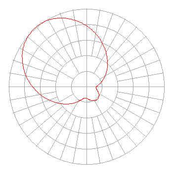 | ||||||||||||||||||||||||
| Azimuth | Ratio | Azimuth | Ratio | Azimuth | Ratio | Azimuth | Ratio | ||||||||||||||||||
| 0 | 0.780 | 10 | 0.688 | 20 | 0.593 | 30 | 0.502 | ||||||||||||||||||
| 40 | 0.418 | 50 | 0.346 | 60 | 0.278 | 70 | 0.217 | ||||||||||||||||||
| 80 | 0.164 | 90 | 0.129 | 100 | 0.126 | 110 | 0.150 | ||||||||||||||||||
| 120 | 0.182 | 130 | 0.206 | 140 | 0.216 | 150 | 0.210 | ||||||||||||||||||
| 160 | 0.192 | 170 | 0.168 | 180 | 0.149 | 190 | 0.151 | ||||||||||||||||||
| 200 | 0.178 | 210 | 0.224 | 220 | 0.282 | 230 | 0.349 | ||||||||||||||||||
| 240 | 0.424 | 250 | 0.507 | 260 | 0.601 | 270 | 0.694 | ||||||||||||||||||
| 280 | 0.789 | 290 | 0.872 | 300 | 0.945 | 310 | 0.987 | ||||||||||||||||||
| 320 | 1.000 | 330 | 0.985 | 340 | 0.936 | 350 | 0.864 | ||||||||||||||||||
Structure Registration Number 1029219 [ASR Heights Differ from WYIN Application] Structure Type: GTOWER Registered To: American Towers LLC Structure Address: 14602 Clark Street (282647) Crown Point, IN County Name: Lake County ASR Issued: 05/25/2023 Date Built: 03/18/2004 Site Elevation: 221 m (725 ft.) Structure Height: 289.6 m (950 ft.) Height Overall: 307.8 m (1010 ft.) Overall Height AMSL: 528.8 m (1735 ft.) FAA Determination: 05/24/2023 FAA Study #: 2023-AGL-5081-OE FAA Circular #: 70/7460-1K Paint & Light FAA Chapters: 4, 7, 12 OM&L to remain the same as prior study = 24-HR HI-STROBES 41-20-59.3 N 87-23-58.1 W (NAD 83) 41-20-59.2 N 87-23-58.0 W (Converted to NAD 27) |
8625 Indiana Place Merrillville, IN 46410 Phone: 219-756-5656 Not-for-Profit | Date: 02/06/2004 Application Certifier NORTHWEST INDIANA PUBLIC BROADCASTING, INC. 8625 Indiana Place Merrillville, IN 46410-6352 Applicant JOHN F.X. BROWNE 38500 Woodward Ave. Suite 350 Bloomfield Hills, MI 48304 CONSULTING ENGINEER LAWRENCE M. MILLER Schwartz, Woods & Miller 1350 Connecticut Avenue, N.w. Suite 300 Washington, DC 20036-1717 | |||||||||||||||||||||||
| |||||||||||||||||||||||||