
FCCInfo.com
A Service of Cavell, Mertz & Associates, Inc.
(855) FCC-INFO
|
|
|
|
|
||||||||||||||||
|
|
Status: License Application Accepted: 12/28/2010 License Expires: 10/01/2022 File Number: BLDTT-20101228ABT Prefix Type: This is BLDTT FCC Website Links: LMS Facility Details This Application Other K25LU-D Applications Including Superseded Applications Mailing Address Correspondence for K25LU-D Correspondence related to application BLDTT-20101228ABT Service Contour - Open Street Map or USGS Map (51 dBu) Service Contour - KML / Google Earth (51 dBu) Rabbit Ears Info Search for K25LU-D Site Location: 36-49-54.6 N 114-03-34.5 W (NAD 83) Site Location: 36-49-54.7 N 114-03-31.6 W (Converted to NAD 27) ERP: 0.515 kW R/C AGL: 24.4 m (80 ft.) R/C AMSL: 598.6 m (1964 ft.) Emission Mask: Simple Site Elevation: 574.2 m. (1884 ft.) Height Overall*: 30.5 m (100 ft.) (* As Filed In This Application, may differ from ASR Data, Below.) Directional Antenna - Antenna Make/Model: Scala 4DR-8-2HW Antenna ID: 101594
| ||||||||||||||||||
| Antenna Data for Antenna Id: 101594 K25LU-D LD File: BLDTT-20101228ABT Scala - 4DR-8-2HW Service: LD Standard Pattern: Y Pattern and Field Values Include a 170° Clockwise Rotation | 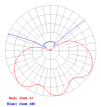 | ||||||||||||||||||
| Azimuth | Ratio | Azimuth | Ratio | Azimuth | Ratio | Azimuth | Ratio | ||||||||||||
| 0 | 0.020 | 10 | 0.020 | 20 | 0.020 | 30 | 0.020 | ||||||||||||
| 40 | 0.020 | 50 | 0.132 | 60 | 0.403 | 70 | 0.570 | ||||||||||||
| 80 | 0.712 | 90 | 0.830 | 100 | 0.917 | 110 | 0.975 | ||||||||||||
| 120 | 0.989 | 130 | 0.910 | 140 | 0.789 | 150 | 0.829 | ||||||||||||
| 160 | 0.950 | 170 | 1.000 | 180 | 0.950 | 190 | 0.829 | ||||||||||||
| 200 | 0.789 | 210 | 0.910 | 220 | 0.989 | 230 | 0.975 | ||||||||||||
| 240 | 0.917 | 250 | 0.830 | 260 | 0.712 | 270 | 0.570 | ||||||||||||
| 280 | 0.403 | 290 | 0.132 | 300 | 0.020 | 310 | 0.020 | ||||||||||||
| 320 | 0.020 | 330 | 0.020 | 340 | 0.020 | 350 | 0.020 | ||||||||||||
Structure Registration Number 1240461 Structure Type: TOWER Registered To: MESQUITE POLICE DEPARTMENT Structure Address: Mesquite Municipal Airport Mesquite, NV County Name: Clark County ASR Issued: 09/29/2003 Site Elevation: 574.2 m (1884 ft.) Structure Height: 30.5 m (100 ft.) Height Overall: 30.5 m (100 ft.) Overall Height AMSL: 604.7 m (1984 ft.) FAA Determination: 11/24/2002 FAA Study #: 2002-AWP-3635-OE FAA Circular #: Paint & Light FAA Chapters: NONE Removed expiration date from determination. Scenario 1./jjs/case#635066 36-49-54.6 N 114-03-34.5 W (NAD 83) 36-49-54.7 N 114-03-31.6 W (Converted to NAD 27) |
3050 E. Flamingo Road Las Vegas, NV 89121 Phone: 702-799-1010 Applicant | Date: 12/28/2010 Application Certifier CLARK COUNTY SCHOOL DISTRICT 3050 E. Flamingo Road Las Vegas, NV 89121 Applicant GEORGE MOLNAR 3050 E. Flamingo Road Las Vegas, NV 89121 DIRECTOR OF ENGINEERING TODD M. STANSBURY Wiley Rein Llp | |||||||||||||||||