
FCCInfo.com
A Service of Cavell, Mertz & Associates, Inc.
(855) FCC-INFO
|
|
KMBB-LD from 12/09/2004 KMBB-LD from 03/12/2004 |
|
|
||||||||||||||||
|
|
Status: License Application Accepted: 11/09/2012 License Expires: 06/01/2022 File Number: BLDTL-20121109AAA Prefix Type: This is BLDTL FCC Website Links: LMS Facility Details This Application Other KMBB-LD Applications Including Superseded Applications Mailing Address Correspondence for KMBB-LD Correspondence related to application BLDTL-20121109AAA Service Contour - Open Street Map or USGS Map (51 dBu) Service Contour - KML / Google Earth (51 dBu) Rabbit Ears Info Search for KMBB-LD Site Location: 41-12-13.0 N 100-44-00.0 W (NAD 83) Site Location: 41-12-13.0 N 100-43-58.5 W (Converted to NAD 27) ERP: 1.36 kW R/C AGL: 100 m (328 ft.) R/C AMSL: 1019.8 m (3346 ft.) Emission Mask: Simple Site Elevation: 919.8 m. (3018 ft.) Height Overall*: 185.6 m (609 ft.) (* As Filed In This Application, may differ from ASR Data, Below.) Directional Antenna - Antenna Make/Model: Scala SL-8 Antenna ID: 23503 | ||||||||||||||||||
| Antenna Data for Antenna Id: 23503 KMBB-LD LD File: BLDTL-20121109AAA Scala - SL-8 Service: LD Standard Pattern: Y Pattern and Field Values Include a 225° Clockwise Rotation | 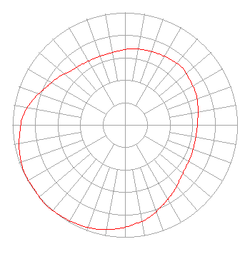 | ||||||||||||||||||
| Azimuth | Ratio | Azimuth | Ratio | Azimuth | Ratio | Azimuth | Ratio | ||||||||||||
| 5 | 0.680 | 15 | 0.690 | 25 | 0.700 | 35 | 0.710 | ||||||||||||
| 45 | 0.720 | 55 | 0.700 | 65 | 0.690 | 75 | 0.670 | ||||||||||||
| 85 | 0.650 | 95 | 0.640 | 105 | 0.640 | 115 | 0.650 | ||||||||||||
| 125 | 0.660 | 135 | 0.690 | 145 | 0.740 | 155 | 0.790 | ||||||||||||
| 165 | 0.850 | 175 | 0.890 | 185 | 0.930 | 195 | 0.960 | ||||||||||||
| 205 | 0.980 | 215 | 0.990 | 225 | 1.000 | 235 | 0.990 | ||||||||||||
| 245 | 0.990 | 255 | 0.970 | 265 | 0.940 | 275 | 0.910 | ||||||||||||
| 285 | 0.850 | 295 | 0.780 | 305 | 0.730 | 315 | 0.680 | ||||||||||||
| 325 | 0.660 | 335 | 0.650 | 345 | 0.650 | 355 | 0.660 | ||||||||||||
Structure Registration Number 1048076 Structure Type: TOWER Registered To: Gray Media Group, Inc. Structure Address: 4.7 Miles Northeast Of Center North Platte, NE County Name: Lincoln County ASR Issued: 09/09/2020 Date Built: 01/01/1940 Site Elevation: 919.8 m (3018 ft.) Structure Height: 185.6 m (609 ft.) Height Overall: 185.6 m (609 ft.) Overall Height AMSL: 1105.4 m (3627 ft.) Paint & Light FAA Chapters: 1, 3, 5, 14, 21 41-12-13.0 N 100-44-00.0 W (NAD 83) 41-12-13.0 N 100-43-58.5 W (Converted to NAD 27) |
3440 S.w. Urish Road Topeka, KS 66614 Phone: 785-478-4726 Not-for-Profit | Date: 11/09/2012 Application Certifier KANSAS-NEBRASKA ASSOCIATION OF SEVENTH-DAY ADVENTISTS 3440 S.w. Urish Road Topeka, KS 66614 Applicant DAN PEEK P.o. Box 220 Frankfort, IL 62896 CONSULTANT DONALD MARTIN Donald E. Martin, P.c. | |||||||||||||||||