
FCCInfo.com
A Service of Cavell, Mertz & Associates, Inc.
(855) FCC-INFO
|
|
K16GM-D from 12/09/2004 |
|
|
||||||||||||||||
|
|
Status: License Application Accepted: 04/29/2010 License Expires: 10/01/2014 File Number: BLDTT-20100429ADE Prefix Type: This is BLDTT FCC Website Links: LMS Facility Details This Application Other K16GM-D Applications Including Superseded Applications Mailing Address Correspondence for K16GM-D Correspondence related to application BLDTT-20100429ADE Service Contour - Open Street Map or USGS Map (51 dBu) Service Contour - KML / Google Earth (51 dBu) Rabbit Ears Info Search for K16GM-D Site Location: 38-59-11.1 N 119-14-39.8 W (NAD 83) Site Location: 38-59-11.4 N 119-14-36.2 W (Converted to NAD 27) ERP: 0.35 kW R/C AGL: 11 m (36 ft.) R/C AMSL: 1950 m (6398 ft.) Emission Mask: Simple Site Elevation: 1939 m. (6362 ft.) Height Overall*: 12.2 m (40 ft.) (* As Filed In This Application, may differ from ASR Data, Below.) Directional Antenna - Antenna Make/Model: Scala 4DR-8S Antenna ID: 20753
| ||||||||||||||||||
| Antenna Data for Antenna Id: 20753 K16GM-D LD File: BLDTT-20100429ADE Scala - 4DR-8S Service: LD Standard Pattern: Y Pattern and Field Values Include a 85° Clockwise Rotation | 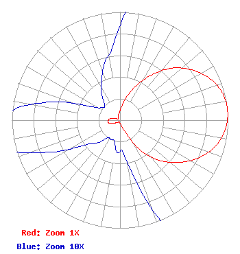 | ||||||||||||||||||
| Azimuth | Ratio | Azimuth | Ratio | Azimuth | Ratio | Azimuth | Ratio | ||||||||||||
| 5 | 0.115 | 15 | 0.210 | 25 | 0.350 | 35 | 0.510 | ||||||||||||
| 45 | 0.680 | 55 | 0.810 | 65 | 0.915 | 75 | 0.980 | ||||||||||||
| 85 | 1.000 | 95 | 0.980 | 105 | 0.917 | 115 | 0.813 | ||||||||||||
| 125 | 0.680 | 135 | 0.530 | 145 | 0.350 | 155 | 0.140 | ||||||||||||
| 165 | 0.060 | 175 | 0.030 | 185 | 0.030 | 195 | 0.020 | ||||||||||||
| 205 | 0.020 | 215 | 0.020 | 225 | 0.030 | 235 | 0.040 | ||||||||||||
| 245 | 0.070 | 255 | 0.105 | 265 | 0.110 | 275 | 0.100 | ||||||||||||
| 285 | 0.065 | 295 | 0.030 | 305 | 0.020 | 315 | 0.020 | ||||||||||||
| 325 | 0.030 | 335 | 0.040 | 345 | 0.055 | 355 | 0.070 | ||||||||||||
Structure Registration Number 1273723 Structure Type: POLE Registered To: Lyon County Structure Address: Mountain Ridge West Of Yerington, Nv. Yerington, NV County Name: Lyon County ASR Issued: 07/16/2012 Site Elevation: 1939.1 m (6362 ft.) Structure Height: 12.2 m (40 ft.) Height Overall: 12.2 m (40 ft.) Overall Height AMSL: 1951.3 m (6402 ft.) FAA Determination: 03/29/2010 FAA Study #: 2010-AWP-2592-OE Paint & Light FAA Chapters: NONE 38-59-11.1 N 119-14-39.8 W (NAD 83) 38-59-11.4 N 119-14-36.2 W (Converted to NAD 27) |
C/o Miles S. Mason, Esq. - Pillsbury Winthrop 1200 Seventeenth Street, Nw Washington, DC 20036 Phone: 202-663-8195 Applicant | Date: 04/29/2010 Application Certifier KTVU PARTNERSHIP 4920 Brookside Court Reno, NV 89502 Applicant MIKE ARNOLD 4920 Brookside Court Reno, NV 89502 CHIEF ENGINEER ROBERT J. FOLLIARD, ESQ. Dow Lohnes Pllc | |||||||||||||||||