
FCCInfo.com
A Service of Cavell, Mertz & Associates, Inc.
(855) FCC-INFO
|
|
K24GT-D from 06/28/2004 |
|
|
||||||||||||||||
|
|
Status: License Application Accepted: 10/03/2006 License Expires: 10/01/2022 File Number: BLDTT-20061003ABS Prefix Type: This is BLDTT FCC Website Links: LMS Facility Details This Application Other K24GT-D Applications Including Superseded Applications Mailing Address Correspondence for K24GT-D Correspondence related to application BLDTT-20061003ABS Service Contour - Open Street Map or USGS Map (51 dBu) Service Contour - KML / Google Earth (51 dBu) Rabbit Ears Info Search for K24GT-D Site Location: 41-50-17.0 N 110-30-14.0 W (NAD 83) Site Location: 41-50-17.2 N 110-30-11.4 W (Converted to NAD 27) ERP: 0.37 kW R/C AGL: 6 m (20 ft.) R/C AMSL: 2449 m (8035 ft.) Emission Mask: Simple Site Elevation: 2443 m. (8015 ft.) Height Overall*: 7.6 m (25 ft.) (* As Filed In This Application, may differ from ASR Data, Below.) Directional Antenna - Antenna Make/Model: Scala SL-8 Antenna ID: 23503
| ||||||||||||||||||
| Antenna Data for Antenna Id: 23503 K24GT-D LD File: BLDTT-20061003ABS Scala - SL-8 Service: LD Standard Pattern: Y | 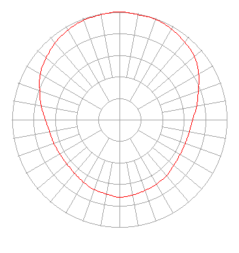 | ||||||||||||||||||
| Azimuth | Ratio | Azimuth | Ratio | Azimuth | Ratio | Azimuth | Ratio | ||||||||||||
| 0 | 1.000 | 10 | 0.990 | 20 | 0.990 | 30 | 0.970 | ||||||||||||
| 40 | 0.940 | 50 | 0.910 | 60 | 0.850 | 70 | 0.780 | ||||||||||||
| 80 | 0.730 | 90 | 0.680 | 100 | 0.660 | 110 | 0.650 | ||||||||||||
| 120 | 0.650 | 130 | 0.660 | 140 | 0.680 | 150 | 0.690 | ||||||||||||
| 160 | 0.700 | 170 | 0.710 | 180 | 0.720 | 190 | 0.700 | ||||||||||||
| 200 | 0.690 | 210 | 0.670 | 220 | 0.650 | 230 | 0.640 | ||||||||||||
| 240 | 0.640 | 250 | 0.650 | 260 | 0.660 | 270 | 0.690 | ||||||||||||
| 280 | 0.740 | 290 | 0.790 | 300 | 0.850 | 310 | 0.890 | ||||||||||||
| 320 | 0.930 | 330 | 0.960 | 340 | 0.980 | 350 | 0.990 | ||||||||||||
Structure Registration Number 1251055 [ASR Heights Differ from K24GT-D Application] Structure Type: TOWER Registered To: Central Wyoming College, KCWC-TV Structure Address: Quealy Peak, 2.3 Miles Ne Of Frontier, Wy Frontier, WY County Name: Lincoln County ASR Issued: 11/22/2005 Date Built: 12/14/2006 Site Elevation: 2443.6 m (8017 ft.) Structure Height: 6.1 m (20 ft.) Height Overall: 7.6 m (25 ft.) Overall Height AMSL: 2451.2 m (8042 ft.) FAA Determination: 11/14/2005 FAA Study #: 2005-ANM-2413-OE Paint & Light FAA Chapters: NONE Removed expiration date from determination. Scenario 1./jjs/case#635066 41-50-17.0 N 110-30-14.0 W (NAD 83) 41-50-17.2 N 110-30-11.4 W (Converted to NAD 27) |
2660 Peck Avenue Riverton, WY 82501 Phone: 307-856-6944 Applicant | Date: 10/03/2006 Application Certifier CENTRAL WYOMING COLLEGE 2660 Peck Ave Riverton, WY 82501 Applicant ROBERT SPAIN 2660 Peck Avenue Riverton, WY 82501 DIRECTOR OF ENGINEERING BOB SPAIN Central Wyoming College Wyoptv | |||||||||||||||||