
FCCInfo.com
A Service of Cavell, Mertz & Associates, Inc.
(855) FCC-INFO
|
|
|
|
|
||||||||||||||||
|
|
Status: License Application Accepted: 11/25/2013 License Expires: 10/01/2022 File Number: BLDTT-20131125BYD Prefix Type: This is BLDTT FCC Website Links: LMS Facility Details This Application Other K30LY-D Applications Including Superseded Applications Mailing Address Correspondence for K30LY-D Correspondence related to application BLDTT-20131125BYD Service Contour - Open Street Map or USGS Map (51 dBu) Service Contour - KML / Google Earth (51 dBu) Rabbit Ears Info Search for K30LY-D Site Location: 40-57-33.5 N 109-25-01.5 W (NAD 83) Site Location: 40-57-33.6 N 109-24-59.0 W (Converted to NAD 27) ERP: 0.072 kW R/C AGL: 6 m (20 ft.) R/C AMSL: 2185 m (7169 ft.) Emission Mask: Simple Site Elevation: 2179 m. (7149 ft.) Height Overall*: 14 m (46 ft.) (* As Filed In This Application, may differ from ASR Data, Below.) Directional Antenna - Antenna Make/Model: Scala 1X2KBBU Antenna ID: 20718
| ||||||||||||||||||
| Antenna Data for Antenna Id: 20718 K30LY-D LD File: BLDTT-20131125BYD Scala - 1X2KBBU Service: LD Standard Pattern: Y Pattern and Field Values Include a 260° Clockwise Rotation | 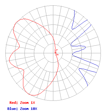 | ||||||||||||||||||
| Azimuth | Ratio | Azimuth | Ratio | Azimuth | Ratio | Azimuth | Ratio | ||||||||||||
| 0 | 0.316 | 10 | 0.202 | 20 | 0.131 | 30 | 0.089 | ||||||||||||
| 40 | 0.065 | 50 | 0.116 | 60 | 0.051 | 70 | 0.043 | ||||||||||||
| 80 | 0.069 | 90 | 0.043 | 100 | 0.051 | 110 | 0.116 | ||||||||||||
| 120 | 0.065 | 130 | 0.089 | 140 | 0.131 | 150 | 0.202 | ||||||||||||
| 160 | 0.316 | 170 | 0.432 | 180 | 0.570 | 190 | 0.738 | ||||||||||||
| 200 | 0.931 | 210 | 1.000 | 220 | 0.955 | 230 | 0.813 | ||||||||||||
| 240 | 0.717 | 250 | 0.846 | 260 | 0.931 | 270 | 0.846 | ||||||||||||
| 280 | 0.717 | 290 | 0.813 | 300 | 0.955 | 310 | 1.000 | ||||||||||||
| 320 | 0.931 | 330 | 0.738 | 340 | 0.570 | 350 | 0.432 | ||||||||||||
Structure Registration Number 1237507 [ASR Heights Differ from K30LY-D Application] Structure Type: LTOWER Registered To: University of Utah Structure Address: Aprox 2 Miles North Of Dutch John, Utah Dutch John, UT County Name: Daggett County ASR Issued: 11/06/2012 Date Built: 10/01/2003 Site Elevation: 2182.7 m (7161 ft.) Structure Height: 7.3 m (24 ft.) Height Overall: 12.8 m (42 ft.) Overall Height AMSL: 2195.5 m (7203 ft.) FAA Determination: 08/21/2011 FAA Study #: 2011-ANM-1463-OE Paint & Light FAA Chapters: NONE PRIOR STUDY 2000-ANM-1275-OE 40-57-33.5 N 109-25-01.5 W (NAD 83) 40-57-33.6 N 109-24-59.0 W (Converted to NAD 27) |
P.o. Box218 Manila, UT 84046 Phone: 435-784-3154 Government Entity | Date: 11/25/2013 Application Certifier DAGGETT COUNTY P.o. Box218 Manila, UT 84046 Applicant RON TITCOMB 4570 Lake Creek Road Heber City, UT 84032 CONSULTING ENGINEER PAT ASBIL Daggett County | |||||||||||||||||