
FCCInfo.com
A Service of Cavell, Mertz & Associates, Inc.
(855) FCC-INFO
|
|
K31EL-D from 01/12/1995 |
|
|
||||||||||||||||
|
|
Status: License Application Accepted: 07/08/2009 License Expires: 10/01/2022 File Number: BLDTT-20090708AJL Prefix Type: This is BLDTT FCC Website Links: LMS Facility Details This Application Other K31EL-D Applications Including Superseded Applications Mailing Address Correspondence for K31EL-D Correspondence related to application BLDTT-20090708AJL Service Contour - Open Street Map or USGS Map (51 dBu) Service Contour - KML / Google Earth (51 dBu) Rabbit Ears Info Search for K31EL-D Site Location: 37-42-40.9 N 112-04-39.4 W (NAD 83) Site Location: 37-42-41.0 N 112-04-36.7 W (Converted to NAD 27) ERP: 0.096 kW R/C AGL: 10 m (33 ft.) R/C AMSL: 2532 m (8307 ft.) Emission Mask: Simple Site Elevation: 2522 m. (8274 ft.) Height Overall*: 13.7 m (45 ft.) (* As Filed In This Application, may differ from ASR Data, Below.) Directional Antenna - Antenna Make/Model: Kathrein K72314 Antenna ID: 19753
| ||||||||||||||||||
| Antenna Data for Antenna Id: 19753 K31EL-D LD File: BLDTT-20090708AJL Kathrein - K72314 Service: LD Standard Pattern: Y Pattern and Field Values Include a 160° Clockwise Rotation | 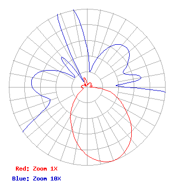 | ||||||||||||||||||
| Azimuth | Ratio | Azimuth | Ratio | Azimuth | Ratio | Azimuth | Ratio | ||||||||||||
| 0 | 0.050 | 10 | 0.020 | 20 | 0.040 | 30 | 0.060 | ||||||||||||
| 40 | 0.070 | 50 | 0.070 | 60 | 0.060 | 70 | 0.050 | ||||||||||||
| 80 | 0.070 | 90 | 0.050 | 100 | 0.270 | 110 | 0.420 | ||||||||||||
| 120 | 0.560 | 130 | 0.730 | 140 | 0.870 | 150 | 0.960 | ||||||||||||
| 160 | 1.000 | 170 | 0.960 | 180 | 0.870 | 190 | 0.730 | ||||||||||||
| 200 | 0.560 | 210 | 0.420 | 220 | 0.270 | 230 | 0.150 | ||||||||||||
| 240 | 0.070 | 250 | 0.050 | 260 | 0.060 | 270 | 0.070 | ||||||||||||
| 280 | 0.070 | 290 | 0.060 | 300 | 0.040 | 310 | 0.020 | ||||||||||||
| 320 | 0.050 | 330 | 0.010 | 340 | 0.120 | 350 | 0.100 | ||||||||||||
Structure Registration Number 1266473 Structure Type: TOWER Registered To: Garfield County Structure Address: Approx. 3 Miles Ne Of The Bryce Canyon Airport. Bryce Canyon, UT County Name: Garfield County ASR Issued: 12/10/2008 Date Built: 12/31/2008 Site Elevation: 2521.9 m (8274 ft.) Structure Height: 12.2 m (40 ft.) Height Overall: 13.7 m (45 ft.) Overall Height AMSL: 2535.6 m (8319 ft.) FAA Determination: 06/24/2008 FAA Study #: 2008-ANM-2085-OE Paint & Light FAA Chapters: NONE Removed expiration date from determination. Scenario 1./jjs/case#635066 37-42-40.9 N 112-04-39.4 W (NAD 83) 37-42-41.0 N 112-04-36.7 W (Converted to NAD 27) |
101 Wasatch Drive Salt Lake City, UT 84112 Phone: 501-585-1601 Government Entity | Date: 07/08/2009 Application Certifier UNIVERSITY OF UTAH 101 S. Wasatch Drive Room 215 Salt Lake City, UT 84112 Applicant MAURI KENT PARSONS 390 South 500 East P.o. Box 473 Monroe, UT 84754 FIELD ENGINEER PHILIP ALAN TITUS | |||||||||||||||||