
FCCInfo.com
A Service of Cavell, Mertz & Associates, Inc.
(855) FCC-INFO
|
|
|
Virtual Channel 21 |
|
||||||||||||||||
|
|
Repacking Information: No changes Status: License Application Accepted: 08/22/2007 License Expires: 02/01/2022 File Number: BLEDT-20070822ACB Prefix Type: This is a license for a noncommercial educational digital TV station FCC Website Links: LMS Facility Details This Application Other KTIN Applications Including Superseded Applications Mailing Address Correspondence for KTIN Correspondence related to application BLEDT-20070822ACB Service Contour - Open Street Map or USGS Map (41 dBu) Service Contour - KML / Google Earth (41 dBu) Public Inspection Files History Cards for KTIN Rabbit Ears Info Search for KTIN Site Location: 42-49-02.7 N 94-24-41.9 W (NAD 83) Site Location: 42-49-02.8 N 94-24-41.0 W (Converted to NAD 27) ERP: 600 kW Polarization: Horizontally polarized HAAT: 355 m (1165 ft.) Electrical Beam Tilt: 0.75 degrees R/C AGL: 355.3 m (1166 ft.) R/C AMSL: 711.3 m (2334 ft.) Site Elevation: 356 m. (1168 ft.) Height Overall*: 365.8 m (1200 ft.) (* As Filed In This Application, may differ from ASR Data, Below.) Directional Antenna - Antenna Make/Model: DIELECTRIC TUA-C4-16/64H-1-R-T Antenna ID: 75579 Polarization: Horizontally polarized | ||||||||||||||||||
| Antenna Data for Antenna Id: 75579 KTIN DT File: BLEDT-20070822ACB DIELECTRIC - TUA-C4-16/64H-1-R-T Service: DT Standard Pattern: Y | 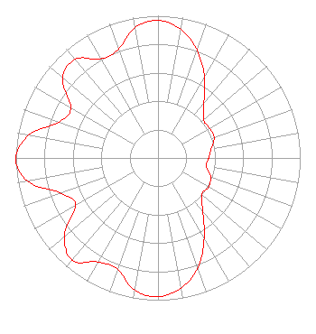 | ||||||||||||||||||
| Azimuth | Ratio | Azimuth | Ratio | Azimuth | Ratio | Azimuth | Ratio | ||||||||||||
| 0 | 0.967 | 10 | 0.918 | 20 | 0.806 | 30 | 0.653 | ||||||||||||
| 40 | 0.502 | 50 | 0.418 | 60 | 0.419 | 70 | 0.420 | ||||||||||||
| 80 | 0.380 | 90 | 0.356 | 100 | 0.345 | 110 | 0.393 | ||||||||||||
| 120 | 0.410 | 130 | 0.401 | 140 | 0.489 | 150 | 0.650 | ||||||||||||
| 160 | 0.821 | 170 | 0.930 | 180 | 0.976 | 190 | 0.944 | ||||||||||||
| 200 | 0.833 | 210 | 0.845 | 220 | 0.939 | 230 | 0.857 | ||||||||||||
| 240 | 0.668 | 250 | 0.726 | 260 | 0.932 | 270 | 1.000 | ||||||||||||
| 280 | 0.922 | 290 | 0.738 | 300 | 0.709 | 310 | 0.875 | ||||||||||||
| 320 | 0.906 | 330 | 0.803 | 340 | 0.813 | 350 | 0.932 | ||||||||||||
Structure Registration Number 1253947 Structure Type: GTOWER Registered To: Iowa Public Broadcast Board, DBA Iowa Public Television Structure Address: 1160 160th Street Bradgate, IA County Name: Humboldt County ASR Issued: 02/16/2017 Date Built: 01/17/2014 Site Elevation: 356 m (1168 ft.) Structure Height: 345.7 m (1134 ft.) Height Overall: 365.8 m (1200 ft.) Overall Height AMSL: 721.8 m (2368 ft.) FAA Determination: 12/30/2013 FAA Study #: 2013-ACE-3613-OE FAA Circular #: 70/7460-1K Paint & Light FAA Chapters: 3, 4, 5, 12 FAA CHAPTERS 3,4,5,12; 70/7460-1K WITH BIRD LIGHTING DEVIATION SPECIAL CONDITION. PRIOR STUDY 2005-ACE-1883-OE 42-49-02.7 N 94-24-41.9 W (NAD 83) 42-49-02.8 N 94-24-41.0 W (Converted to NAD 27) |
6450 Corporate Drive Johnston, IA 50131 Phone: 515-725-9700 Government Entity | Date: 08/22/2007 Application Certifier IOWA PUBLIC BROADCASTING BOARD P.o. Box 6450 Johnston, IA 50131-6450 Applicant WILLIAM T. HAYES Po Box 6450 Johnston, IA 50131-6450 DIRECTOR OF ENGINEERING TODD D. GRAY Dow Lohnes Pllc 1200 New Hampshire Ave., N.w. Suite 800 Washington, DC 20036-6802 | |||||||||||||||||