FCCInfo.com
A Service of Cavell, Mertz & Associates, Inc.
(855) FCC-INFO
|
|
KSL from ??? |
Virtual Channel 5 |  |
|
|||||||||||||||||||||||||||||||||||||||||||||||||||||||||||||||||||||||||||
|
|
Status: LIC Application Accepted: 12/15/2003 License Expires: 10/01/2030 File Number: BXLCDT-20031215AAW Prefix Type: This is BXLCDT FCC Website Links: LMS Facility Details This Application Other KSL-TV Applications Including Superseded Applications Service Contour - Open Street Map or USGS Map (41 dBu) Service Contour - KML / Google Earth (41 dBu) Public Inspection Files Rabbit Ears Info Search for KSL-TV Site Location: 40-39-35.0 N 112-12-07.5 W (NAD 83) Site Location: 40-39-35.2 N 112-12-04.7 W (Converted to NAD 27) ERP: 295 kW Polarization: Horizontally polarized HAAT: 1128 m (3701 ft.) Electrical Beam Tilt: 1.5 degrees R/C AGL: 36 m (118 ft.) R/C AMSL: 2790 m (9154 ft.) Site Elevation: 2754 m. (9035 ft.) Height Overall*: 86 m (282 ft.) (* As Filed In This Application, may differ from ASR Data, Below.) Directional Antenna - Antenna Make/Model: Kathrein K773928 Antenna ID: 19903 Polarization: Horizontally polarized | ||||||||||||||||||||||||||||||||||||||||||||||||||||||||||||||||||||||||||||||
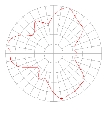
| Antenna Data for Antenna Id: 19903 KSL-TV DX File: BXLCDT-20031215AAW Kathrein - K773928 Service: DX Standard Pattern: Y |  | ||||||||||||||||||||||||||||||||||||||||||||||||||||||||||||||||||||||||||||||
| Azimuth | Ratio | Azimuth | Ratio | Azimuth | Ratio | Azimuth | Ratio | ||||||||||||||||||||||||||||||||||||||||||||||||||||||||||||||||||||||||
| 0 | 0.782 | 10 | 0.933 | 18 | 1.000 | 20 | 0.992 | ||||||||||||||||||||||||||||||||||||||||||||||||||||||||||||||||||||||||
| 30 | 0.890 | 40 | 0.831 | 50 | 0.801 | 60 | 0.613 | ||||||||||||||||||||||||||||||||||||||||||||||||||||||||||||||||||||||||
| 70 | 0.468 | 80 | 0.438 | 90 | 0.492 | 100 | 0.452 | ||||||||||||||||||||||||||||||||||||||||||||||||||||||||||||||||||||||||
| 110 | 0.494 | 120 | 0.642 | 130 | 0.829 | 140 | 0.860 | ||||||||||||||||||||||||||||||||||||||||||||||||||||||||||||||||||||||||
| 150 | 0.899 | 160 | 0.918 | 170 | 0.953 | 180 | 0.816 | ||||||||||||||||||||||||||||||||||||||||||||||||||||||||||||||||||||||||
| 190 | 0.638 | 200 | 0.546 | 210 | 0.618 | 220 | 0.462 | ||||||||||||||||||||||||||||||||||||||||||||||||||||||||||||||||||||||||
| 230 | 0.455 | 240 | 0.589 | 250 | 0.779 | 260 | 0.895 | ||||||||||||||||||||||||||||||||||||||||||||||||||||||||||||||||||||||||
| 270 | 0.881 | 280 | 0.964 | 290 | 0.925 | 300 | 0.766 | ||||||||||||||||||||||||||||||||||||||||||||||||||||||||||||||||||||||||
| 310 | 0.581 | 320 | 0.612 | 330 | 0.759 | 340 | 0.689 | ||||||||||||||||||||||||||||||||||||||||||||||||||||||||||||||||||||||||
| 350 | 0.631 | ||||||||||||||||||||||||||||||||||||||||||||||||||||||||||||||||||||||||||||||
Structure Registration Number 1237796 [ASR Heights Differ from KSL-TV Application] Structure Type: TOWER Registered To: Bonneville International Corporation Structure Address: Farnsworth Peak Salt Lake City, UT County Name: Salt Lake County ASR Issued: 01/05/2004 Date Built: 08/25/2003 Site Elevation: 2755 m (9039 ft.) Structure Height: 86 m (282 ft.) Height Overall: 86 m (282 ft.) Overall Height AMSL: 2841 m (9321 ft.) FAA Determination: 12/23/2003 FAA Study #: 2003-ANM-2275-OE FAA Circular #: 70/7460-1K Paint & Light FAA Chapters: 4, 8, 12 PRIOR STUDY 2002-ANM-1816-OE 40-39-35.0 N 112-12-07.5 W (NAD 83) 40-39-35.2 N 112-12-04.7 W (Converted to NAD 27) |
55 North 300 West 2nd Floor Salt Lake City, UT 84101 Phone: 801-575-5872 Corporation | Date: 12/15/2003 Application Certifier Bonneville Holding Company 55 North 300 West Salt Lake City, UT 84110 Applicant J. Talmage Ball 55 North 300 West Salt Lake City, UT 84180-1160 V.P. Engineer, Bonneville International Corporation Kenneth E. Satten Wilkinson Barker Knauer, LLP 2300 N Street, N.W. Suite 700 Washington, DC 20037-1128 | |||||||||||||||||||||||||||||||||||||||||||||||||||||||||||||||||||||||||||||
|
| ||||||||||||||||||||||||||||||||||||||||||||||||||||||||||||||||||||||||||||||