
FCCInfo.com
A Service of Cavell, Mertz & Associates, Inc.
(855) FCC-INFO
|
|
|
|
|
||||||||||||||||
|
|
Status: License Application Accepted: 09/06/2012 License Expires: 10/01/2022 File Number: BLDTL-20120906ABB Prefix Type: This is BLDTL FCC Website Links: LMS Facility Details This Application Other KYUU-LD Applications Including Superseded Applications Mailing Address Correspondence for KYUU-LD Correspondence related to application BLDTL-20120906ABB Service Contour - Open Street Map or USGS Map (51 dBu) Service Contour - KML / Google Earth (51 dBu) Rabbit Ears Info Search for KYUU-LD Site Location: 43-45-20.8 N 116-05-57.0 W (NAD 83) Site Location: 43-45-21.2 N 116-05-53.6 W (Converted to NAD 27) ERP: 8.8 kW Electrical Beam Tilt: 0.75 degrees R/C AGL: 93.6 m (307 ft.) R/C AMSL: 2244.6 m (7364 ft.) Emission Mask: Full Service Site Elevation: 2151 m. (7057 ft.) Height Overall*: 102.4 m (336 ft.) (* As Filed In This Application, may differ from ASR Data, Below.) Directional Antenna - Antenna Make/Model: DIELECTRIC TAD-UDC-3-28 Antenna ID: 108956 | ||||||||||||||||||
| Antenna Data for Antenna Id: 108956 KYUU-LD LD File: BLDTL-20120906ABB DIELECTRIC - TAD-UDC-3-28 Service: LD Standard Pattern: Y | 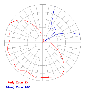 | ||||||||||||||||||
| Azimuth | Ratio | Azimuth | Ratio | Azimuth | Ratio | Azimuth | Ratio | ||||||||||||
| 0 | 0.188 | 10 | 0.196 | 20 | 0.085 | 30 | 0.043 | ||||||||||||
| 40 | 0.050 | 50 | 0.040 | 54 | 0.005 | 60 | 0.041 | ||||||||||||
| 70 | 0.073 | 80 | 0.114 | 90 | 0.208 | 100 | 0.255 | ||||||||||||
| 110 | 0.363 | 120 | 0.509 | 130 | 0.692 | 140 | 0.877 | ||||||||||||
| 150 | 0.990 | 154 | 1.000 | 160 | 0.983 | 170 | 0.928 | ||||||||||||
| 180 | 0.912 | 190 | 0.933 | 200 | 0.889 | 210 | 0.861 | ||||||||||||
| 220 | 0.938 | 230 | 0.941 | 240 | 0.881 | 250 | 0.916 | ||||||||||||
| 260 | 0.933 | 270 | 0.870 | 280 | 0.858 | 290 | 0.937 | ||||||||||||
| 300 | 0.981 | 310 | 0.894 | 320 | 0.763 | 330 | 0.555 | ||||||||||||
| 340 | 0.404 | 350 | 0.260 | ||||||||||||||||
Structure Registration Number 1209884 Structure Type: TOWER Registered To: The Deer Point Tower Venture, LLC Structure Address: 11miles North-northwest Of Boise, Id Atop Deer Point/schafer Butte Boise, ID County Name: Boise County ASR Issued: 08/22/2007 Date Built: 09/15/2001 Site Elevation: 2151 m (7057 ft.) Structure Height: 102.4 m (336 ft.) Height Overall: 102.4 m (336 ft.) Overall Height AMSL: 2253.4 m (7393 ft.) FAA Determination: 12/07/1999 FAA Study #: 99-ANM-1320-OE FAA Circular #: 70/7460-1J Paint & Light FAA Chapters: 4, 8, 13 Removed expiration date from determination. Scenario 1./jjs/case#635066 43-45-20.8 N 116-05-57.0 W (NAD 83) 43-45-21.2 N 116-05-53.6 W (Converted to NAD 27) |
10706 Beaver Dam Road Cockeysville, MD 21030 Phone: 410-568-1500 Limited Liability Company | Date: 09/06/2012 Application Certifier FISHER BROADCASTING COMPANY 140 Fourth Avenue North Suite 500 Seattle, WA 98109 Applicant LOUIS R DUTREIL JR Dutreil Lundin & Rackley Inc 201 Fletcher Ave Sarasota, FL 34237-6019 CONSULTING ENGINEER STEPHEN HARTZELL Brooks, Pierce, Et. Al. | |||||||||||||||||