
FCCInfo.com
A Service of Cavell, Mertz & Associates, Inc.
(855) FCC-INFO
|
|
KFFX-TV from 04/11/1997 |
Virtual Channel 11 |  |
|
|||||||||||||||||||||
|
|
Repacking Information: No changes Status: License Application Accepted: 04/24/2014 License Expires: 02/01/2015 File Number: BLCDT-20140424AHO Prefix Type: This is a License for a commercial digital TV station FCC Website Links: LMS Facility Details This Application Other KFFX-TV Applications Including Superseded Applications Mailing Address Correspondence for KFFX-TV Correspondence related to application BLCDT-20140424AHO Service Contour - Open Street Map or USGS Map (36 dBu) Service Contour - KML / Google Earth (36 dBu) Public Inspection Files Rabbit Ears Info Search for KFFX-TV Site Location: 45-44-51.1 N 118-02-18.6 W (NAD 83) Site Location: 45-44-51.6 N 118-02-14.8 W (Converted to NAD 27) ERP: 60 kW Polarization: Horizontally polarized HAAT: 471 m (1545 ft.) Electrical Beam Tilt: 1.5 degrees R/C AGL: 67 m (220 ft.) R/C AMSL: 1737 m (5699 ft.) Site Elevation: 1670 m. (5479 ft.) Height Overall*: 77.8 m (255 ft.) (* As Filed In This Application, may differ from ASR Data, Below.) Directional Antenna - Antenna Make/Model: Andrew ATW-12V6-HSC-11 Antenna ID: 117936 Polarization: Horizontally polarized
| ||||||||||||||||||||||||
| Antenna Data for Antenna Id: 117936 KFFX-TV DT File: BLCDT-20140424AHO Andrew - ATW-12V6-HSC-11 Service: DT Standard Pattern: Y | 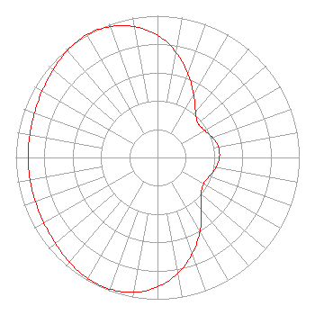 | ||||||||||||||||||||||||
| Azimuth | Ratio | Azimuth | Ratio | Azimuth | Ratio | Azimuth | Ratio | ||||||||||||||||||
| 0 | 0.863 | 10 | 0.753 | 20 | 0.629 | 30 | 0.509 | ||||||||||||||||||
| 40 | 0.417 | 50 | 0.374 | 60 | 0.383 | 70 | 0.412 | ||||||||||||||||||
| 80 | 0.436 | 90 | 0.437 | 100 | 0.418 | 110 | 0.388 | ||||||||||||||||||
| 120 | 0.374 | 130 | 0.403 | 140 | 0.483 | 150 | 0.599 | ||||||||||||||||||
| 160 | 0.720 | 170 | 0.829 | 180 | 0.913 | 190 | 0.966 | ||||||||||||||||||
| 200 | 0.988 | 210 | 0.984 | 220 | 0.965 | 230 | 0.941 | ||||||||||||||||||
| 240 | 0.925 | 250 | 0.916 | 260 | 0.913 | 270 | 0.913 | ||||||||||||||||||
| 280 | 0.915 | 290 | 0.923 | 300 | 0.939 | 310 | 0.961 | ||||||||||||||||||
| 320 | 0.987 | 330 | 1.000 | 340 | 0.983 | 350 | 0.937 | ||||||||||||||||||
Structure Registration Number 1205225 Structure Type: GTOWER Registered To: Imagicomm Yakima Operations LLC Structure Address: Spout Springs Communcations Site, 59.1 Km From Pendleton, Or At 82 Deg. Trure Pendleton, OR County Name: Union County ASR Issued: 09/20/2022 Date Built: 08/18/2014 Site Elevation: 1670.3 m (5480 ft.) Structure Height: 76.7 m (252 ft.) Height Overall: 77.7 m (255 ft.) Overall Height AMSL: 1748 m (5735 ft.) FAA Determination: 02/06/2014 FAA Study #: 2013-ANM-2852-OE FAA Circular #: 70/7460-1K Paint & Light FAA Chapters: 4, 6, 12 PRIOR STUDY 1996-ANM-608-OE 45-44-51.1 N 118-02-18.6 W (NAD 83) 45-44-51.6 N 118-02-14.8 W (Converted to NAD 27) |
3000 Worldreach Drive Indian Land, SC 29707 Phone: 803-578-1418 Limited Liability Company | Date: 04/24/2014 Application Certifier MOUNTAIN LICENSES, L.P. C/o Northwest Broadcasting, Inc. 2111 University Park Drive, Suite 650 Okemos, MI 48864 Applicant RON SWEATTE 4600 S Regal St Spokane, WA 99223 CHIEF TECHNOLOGY OFFICER DENNIS P. CORBETT, ESQ. Lerman Senter Pllc 2000 K Street, Nw Suite 600 Washington, DC 20006-1809 | |||||||||||||||||||||||
| |||||||||||||||||||||||||