
FCCInfo.com
A Service of Cavell, Mertz & Associates, Inc.
(855) FCC-INFO
|
|
KREM from 11/17/1980 |
Virtual Channel 2 |  |
|
|||||||||||||||||||||||||||||||||||||||||||||||||||||||||||||||||||||||||||
|
|
Repacking Information: No changes Status: License (Licensed And Reduced Power) Application Accepted: 06/23/2005 License Expires: 02/01/2023 File Number: BLCDT-20050623ABG Prefix Type: This is a License for a commercial digital TV station FCC Website Links: LMS Facility Details This Application Other KREM Applications Including Superseded Applications Mailing Address Correspondence for KREM Correspondence related to application BLCDT-20050623ABG Service Contour - Open Street Map or USGS Map (41 dBu) Service Contour - KML / Google Earth (41 dBu) Public Inspection Files History Cards for KREM Rabbit Ears Info Search for KREM Site Location: 47-35-41.0 N 117-17-57.0 W (NAD 83) Site Location: 47-35-41.4 N 117-17-53.3 W (Converted to NAD 27) ERP: 893 kW Polarization: Horizontally polarized HAAT: 641 m (2103 ft.) Electrical Beam Tilt: 1 degree R/C AGL: 242 m (794 ft.) R/C AMSL: 1342 m (4403 ft.) Site Elevation: 1100 m. (3609 ft.) Height Overall*: 286.5 m (940 ft.) (* As Filed In This Application, may differ from ASR Data, Below.) Directional Antenna - Antenna Make/Model: DIELECTRIC TFU-24DSB-H(C) Antenna ID: 64696 Polarization: Horizontally polarized
| ||||||||||||||||||||||||||||||||||||||||||||||||||||||||||||||||||||||||||||||
| Antenna Data for Antenna Id: 64696 KREM DT File: BLCDT-20050623ABG DIELECTRIC - TFU-24DSB-H(C) Service: DT Standard Pattern: Y | 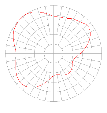 | ||||||||||||||||||||||||||||||||||||||||||||||||||||||||||||||||||||||||||||||
| Azimuth | Ratio | Azimuth | Ratio | Azimuth | Ratio | Azimuth | Ratio | ||||||||||||||||||||||||||||||||||||||||||||||||||||||||||||||||||||||||
| 0 | 0.776 | 10 | 0.768 | 20 | 0.779 | 30 | 0.828 | ||||||||||||||||||||||||||||||||||||||||||||||||||||||||||||||||||||||||
| 40 | 0.855 | 50 | 0.911 | 60 | 0.880 | 70 | 0.788 | ||||||||||||||||||||||||||||||||||||||||||||||||||||||||||||||||||||||||
| 80 | 0.673 | 90 | 0.560 | 100 | 0.467 | 110 | 0.430 | ||||||||||||||||||||||||||||||||||||||||||||||||||||||||||||||||||||||||
| 120 | 0.452 | 130 | 0.495 | 140 | 0.521 | 150 | 0.511 | ||||||||||||||||||||||||||||||||||||||||||||||||||||||||||||||||||||||||
| 160 | 0.477 | 170 | 0.446 | 180 | 0.468 | 190 | 0.560 | ||||||||||||||||||||||||||||||||||||||||||||||||||||||||||||||||||||||||
| 200 | 0.688 | 210 | 0.810 | 220 | 0.891 | 230 | 0.918 | ||||||||||||||||||||||||||||||||||||||||||||||||||||||||||||||||||||||||
| 240 | 0.885 | 250 | 0.834 | 260 | 0.793 | 270 | 0.777 | ||||||||||||||||||||||||||||||||||||||||||||||||||||||||||||||||||||||||
| 280 | 0.816 | 290 | 0.885 | 300 | 0.949 | 310 | 0.984 | ||||||||||||||||||||||||||||||||||||||||||||||||||||||||||||||||||||||||
| 320 | 1.000 | 330 | 0.977 | 340 | 0.917 | 350 | 0.842 | ||||||||||||||||||||||||||||||||||||||||||||||||||||||||||||||||||||||||
Structure Registration Number 1033992 Structure Type: TOWER Registered To: King Broadcasting Company Structure Address: Krell Hill 7 Mi Se Spokane, WA County Name: Spokane County ASR Issued: 02/13/2019 Date Built: 08/01/1963 Site Elevation: 1100 m (3609 ft.) Structure Height: 258.3 m (847 ft.) Height Overall: 286.5 m (940 ft.) Overall Height AMSL: 1386.5 m (4549 ft.) FAA Determination: 03/23/1990 FAA Study #: 90-ANM-0098-OE Paint & Light FAA Chapters: 1, 3, 7, 16, 21 47-35-41.0 N 117-17-57.0 W (NAD 83) 47-35-41.4 N 117-17-53.3 W (Converted to NAD 27) |
Tegna, Inc. 8350 Broad Street, Suite 2000 Tysons, VA 22102 Phone: 703-873-6606 Corporation | Date: 06/23/2005 Application Certifier KING BROADCASTING COMPANY 400 South Record Street Dallas, TX 75202 Applicant BOYD LUNDBERG 4103 South Regal Street Spokane, WA 99223 CHIEF ENGINEER JOHN BURGETT Wiley Rein & Fielding Llp 1776 K Street, Nw Washington, DC 20006 | |||||||||||||||||||||||||||||||||||||||||||||||||||||||||||||||||||||||||||||
|
| ||||||||||||||||||||||||||||||||||||||||||||||||||||||||||||||||||||||||||||||