
FCCInfo.com
A Service of Cavell, Mertz & Associates, Inc.
(855) FCC-INFO
|
|
|
|
|
||||||||||||||||
|
|
Status: License Application Accepted: 12/05/2012 License Expires: 04/01/2022 File Number: BLDTL-20121205ABT Prefix Type: This is BLDTL FCC Website Links: LMS Facility Details This Application Other K22JN-D Applications Including Superseded Applications Mailing Address Correspondence for K22JN-D Correspondence related to application BLDTL-20121205ABT Service Contour - Open Street Map or USGS Map (51 dBu) Service Contour - KML / Google Earth (51 dBu) Rabbit Ears Info Search for K22JN-D Site Location: 39-03-59.3 N 108-44-43.3 W (NAD 83) Site Location: 39-03-59.4 N 108-44-40.9 W (Converted to NAD 27) ERP: 4 kW Electrical Beam Tilt: 2 degrees R/C AGL: 37 m (121 ft.) R/C AMSL: 2192 m (7192 ft.) Emission Mask: Stringent Site Elevation: 2155 m. (7070 ft.) Height Overall*: 105.2 m (345 ft.) (* As Filed In This Application, may differ from ASR Data, Below.) Directional Antenna - Antenna Make/Model: Propagation System Inc PSILP8BA-22 Antenna ID: 111000 | ||||||||||||||||||
| Antenna Data for Antenna Id: 111000 K22JN-D LD File: BLDTL-20121205ABT Propagation System Inc - PSILP8BA-22 Service: LD Standard Pattern: Y Pattern and Field Values Include a 50° Clockwise Rotation | 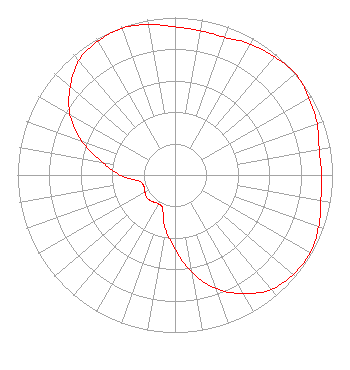 | ||||||||||||||||||
| Azimuth | Ratio | Azimuth | Ratio | Azimuth | Ratio | Azimuth | Ratio | ||||||||||||
| 0 | 0.940 | 10 | 0.930 | 20 | 0.930 | 30 | 0.960 | ||||||||||||
| 40 | 0.980 | 50 | 1.000 | 60 | 0.980 | 70 | 0.960 | ||||||||||||
| 80 | 0.930 | 90 | 0.930 | 100 | 0.940 | 110 | 0.970 | ||||||||||||
| 120 | 0.990 | 130 | 0.980 | 140 | 0.950 | 150 | 0.870 | ||||||||||||
| 160 | 0.770 | 170 | 0.630 | 180 | 0.470 | 190 | 0.350 | ||||||||||||
| 200 | 0.230 | 210 | 0.210 | 220 | 0.220 | 230 | 0.230 | ||||||||||||
| 240 | 0.220 | 250 | 0.210 | 260 | 0.230 | 270 | 0.350 | ||||||||||||
| 280 | 0.470 | 290 | 0.630 | 300 | 0.770 | 310 | 0.870 | ||||||||||||
| 320 | 0.950 | 330 | 0.980 | 340 | 0.990 | 350 | 0.970 | ||||||||||||
Structure Registration Number 1226999 Structure Type: TOWER Registered To: MBC GRAND BROADCASTING INC Structure Address: Black Ridge Communications Site 8.7 Miles South Of Fruita, CO County Name: Mesa County ASR Issued: 05/03/2013 Date Built: 07/12/2002 Site Elevation: 2155 m (7070 ft.) Structure Height: 104.7 m (344 ft.) Height Overall: 105.2 m (345 ft.) Overall Height AMSL: 2260.2 m (7415 ft.) FAA Determination: 02/13/2002 FAA Study #: 01-ANM-3788-OE FAA Circular #: 70/7460-1K Paint & Light FAA Chapters: 3, 4, 5, 12 Removed expiration date from determination. Scenario 1./jjs/case#635066 39-03-59.3 N 108-44-43.3 W (NAD 83) 39-03-59.4 N 108-44-40.9 W (Converted to NAD 27) |
1360 E. Sherwood Drive Grand Junction, CO 81501 Phone: 970-254-2112 Applicant | Date: 12/05/2012 Application Certifier MBC GRAND BROADCASTING, INC. 1360 E. Sherwood Drive Grand Junction, CO 81501 Applicant LARRY H. WILL P.E. 1055 Powderhorn Drive Glen Mills, PA 19342-9504 CONSULTING ENGINEER MELODIE A. VIRTUE, ESQ. Garvey Schubert Barer | |||||||||||||||||