
FCCInfo.com
A Service of Cavell, Mertz & Associates, Inc.
(855) FCC-INFO
|
|
K31KL-D from 04/09/1999 K31KL-D from 11/27/1998 K31KL-D from 10/05/1998 |
|
|
||||||||||||||||
|
|
Repacking Information: No changes Status: License Application Accepted: 12/07/2009 License Expires: 02/01/2023 File Number: BLDTA-20091207ADH Prefix Type: This is BLDTA FCC Website Links: LMS Facility Details This Application Other K31KL-D Applications Including Superseded Applications Mailing Address Correspondence for K31KL-D Correspondence related to application BLDTA-20091207ADH Service Contour - Open Street Map or USGS Map (51 dBu) Service Contour - KML / Google Earth (51 dBu) Public Inspection Files Rabbit Ears Info Search for K31KL-D Site Location: 46-03-44.6 N 118-23-04.9 W (NAD 83) Site Location: 46-03-45.1 N 118-23-01.0 W (Converted to NAD 27) ERP: 2.8 kW R/C AGL: 39.9 m (131 ft.) R/C AMSL: 296.9 m (974 ft.) Emission Mask: Stringent Site Elevation: 257 m. (843 ft.) Height Overall*: 42.7 m (140 ft.) (* As Filed In This Application, may differ from ASR Data, Below.) Directional Antenna - Antenna Make/Model: Propagation System Inc PSILP16BA Antenna ID: 20384 | ||||||||||||||||||
| Antenna Data for Antenna Id: 20384 K31KL-D DC File: BLDTA-20091207ADH Propagation System Inc - PSILP16BA Service: DC Standard Pattern: Y Pattern and Field Values Include a 180° Clockwise Rotation | 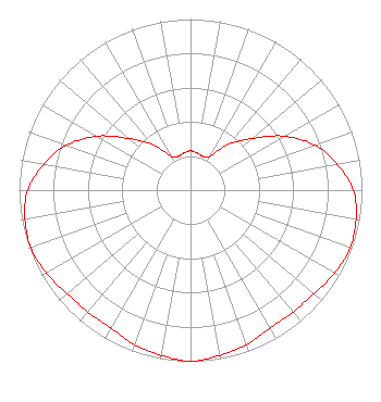 | ||||||||||||||||||
| Azimuth | Ratio | Azimuth | Ratio | Azimuth | Ratio | Azimuth | Ratio | ||||||||||||
| 0 | 0.230 | 10 | 0.220 | 20 | 0.210 | 30 | 0.230 | ||||||||||||
| 40 | 0.350 | 50 | 0.470 | 60 | 0.630 | 70 | 0.770 | ||||||||||||
| 80 | 0.870 | 90 | 0.950 | 100 | 0.980 | 110 | 0.990 | ||||||||||||
| 120 | 0.970 | 130 | 0.940 | 140 | 0.930 | 150 | 0.930 | ||||||||||||
| 160 | 0.960 | 170 | 0.980 | 180 | 1.000 | 190 | 0.980 | ||||||||||||
| 200 | 0.960 | 210 | 0.930 | 220 | 0.930 | 230 | 0.940 | ||||||||||||
| 240 | 0.970 | 250 | 0.990 | 260 | 0.980 | 270 | 0.950 | ||||||||||||
| 280 | 0.870 | 290 | 0.770 | 300 | 0.630 | 310 | 0.470 | ||||||||||||
| 320 | 0.350 | 330 | 0.230 | 340 | 0.210 | 350 | 0.220 | ||||||||||||
Structure Registration Number 1268967 Structure Type: TOWER Registered To: Blue Mountain Broadcasting Association Structure Address: Ne Of Intersection Of Gose Road And Electric Avenue College Place, WA County Name: Walla Walla County ASR Issued: 07/08/2009 Date Built: 01/01/1968 Site Elevation: 257 m (843 ft.) Structure Height: 42.6 m (140 ft.) Height Overall: 42.6 m (140 ft.) Overall Height AMSL: 299.6 m (983 ft.) FAA Determination: 07/06/2009 FAA Study #: 2009-ANM-644-OE Paint & Light FAA Chapters: NONE 46-03-44.6 N 118-23-04.9 W (NAD 83) 46-03-45.1 N 118-23-01.0 W (Converted to NAD 27) |
1470 Wallula Avenue Walla Walla, WA 99362 Phone: 509-529-9149 Not-for-Profit | Date: 12/07/2009 Application Certifier BLUE MOUNTAIN BROADCASTING ASSOCIATION P. O. Box 205 College Place, WA 99324 Applicant B. W. ST.CLAIR 2355 Ranch Drive Westminster, CO 80234 ENGINEERING CONSULTANT JIM FORSYTH Walla Walla University | |||||||||||||||||