
FCCInfo.com
A Service of Cavell, Mertz & Associates, Inc.
(855) FCC-INFO
|
|
WRGX-LD from 04/13/2013 |
|
|
||||||||||||||||
|
|
Status: License Application Accepted: 05/31/2013 License Expires: 04/01/2021 File Number: BLDTL-20130531ATB Prefix Type: This is BLDTL FCC Website Links: LMS Facility Details This Application Other WRGX-LD Applications Including Superseded Applications Mailing Address Correspondence for WRGX-LD Correspondence related to application BLDTL-20130531ATB Service Contour - Open Street Map or USGS Map (51 dBu) Service Contour - KML / Google Earth (51 dBu) Rabbit Ears Info Search for WRGX-LD Site Location: 30-55-12.0 N 85-44-30.0 W (NAD 83) Site Location: 30-55-11.3 N 85-44-30.2 W (Converted to NAD 27) ERP: 15 kW Electrical Beam Tilt: 0.75 degrees R/C AGL: 480.1 m (1575 ft.) R/C AMSL: 521.2 m (1710 ft.) Emission Mask: Stringent Site Elevation: 41.1 m. (135 ft.) Height Overall*: 579.4 m (1901 ft.) (* As Filed In This Application, may differ from ASR Data, Below.) Directional Antenna - Antenna Make/Model: Electronics Research Inc. ALP12L3-HSMR-23 Antenna ID: 111614 | ||||||||||||||||||
| Antenna Data for Antenna Id: 111614 WRGX-LD LD File: BLDTL-20130531ATB Electronics Research Inc. - ALP12L3-HSMR-23 Service: LD Standard Pattern: Y | 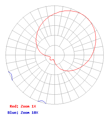 | ||||||||||||||||||
| Azimuth | Ratio | Azimuth | Ratio | Azimuth | Ratio | Azimuth | Ratio | ||||||||||||
| 0 | 0.832 | 10 | 0.895 | 20 | 0.949 | 30 | 0.985 | ||||||||||||
| 40 | 1.000 | 50 | 0.985 | 60 | 0.949 | 70 | 0.895 | ||||||||||||
| 80 | 0.832 | 90 | 0.767 | 100 | 0.698 | 110 | 0.626 | ||||||||||||
| 120 | 0.556 | 130 | 0.490 | 140 | 0.425 | 150 | 0.358 | ||||||||||||
| 160 | 0.287 | 170 | 0.212 | 180 | 0.141 | 190 | 0.101 | ||||||||||||
| 200 | 0.100 | 210 | 0.122 | 220 | 0.132 | 230 | 0.122 | ||||||||||||
| 240 | 0.100 | 250 | 0.101 | 260 | 0.141 | 270 | 0.212 | ||||||||||||
| 280 | 0.287 | 290 | 0.358 | 300 | 0.425 | 310 | 0.490 | ||||||||||||
| 320 | 0.556 | 330 | 0.626 | 340 | 0.698 | 350 | 0.767 | ||||||||||||
Structure Registration Number 1056648 Structure Type: TOWER Registered To: Gray Media Group, Inc. Structure Address: 2.1 Mi S Millers Crossroads, FL County Name: Holmes County ASR Issued: 09/09/2020 Date Built: 02/01/1978 Site Elevation: 41.1 m (135 ft.) Structure Height: 554.7 m (1820 ft.) Height Overall: 579.4 m (1901 ft.) Overall Height AMSL: 620.5 m (2036 ft.) FAA Determination: 09/15/1998 FAA Study #: 98-ASO-5140-OE FAA Circular #: 70/7460-1J Paint & Light FAA Chapters: 4, 7, 13 30-55-12.0 N 85-44-30.0 W (NAD 83) 30-55-11.3 N 85-44-30.2 W (Converted to NAD 27) |
4370 Peachtree Road, Ne Atlanta, GA 30319 Phone: 202-505-2401 Applicant | Date: 05/31/2013 Application Certifier GRAY TELEVISION LICENSEE, LLC 285 North Foster Street Dothan, AL 36303 Applicant TOM JOHNSON 285 North Foster Street Dothan, AL 36303 CHIEF ENGINEER JOAN STEWART, ESQ. Wiley Rein Llp | |||||||||||||||||