
FCCInfo.com
A Service of Cavell, Mertz & Associates, Inc.
(855) FCC-INFO
|
|
|
Virtual Channel 65 |
|
||||||||||||||||
|
|
Repacking Information: No changes Status: License Application Accepted: 02/17/2012 License Expires: 08/01/2021 File Number: BLCDT-20120217AAO Prefix Type: This is a License for a commercial digital TV station FCC Website Links: LMS Facility Details This Application Other WLJC-TV Applications Including Superseded Applications Mailing Address Correspondence for WLJC-TV Correspondence related to application BLCDT-20120217AAO Service Contour - Open Street Map or USGS Map (36 dBu) Service Contour - KML / Google Earth (36 dBu) Public Inspection Files Rabbit Ears Info Search for WLJC-TV Site Location: 37-36-47.3 N 83-40-17.6 W (NAD 83) Site Location: 37-36-47.0 N 83-40-17.9 W (Converted to NAD 27) ERP: 185 kW Polarization: Horizontally polarized HAAT: 321.5 m (1055 ft.) Electrical Beam Tilt: 1.25 degrees R/C AGL: 296.3 m (972 ft.) R/C AMSL: 595 m (1952 ft.) Site Elevation: 298.7 m. (980 ft.) Height Overall*: 304.8 m (1000 ft.) (* As Filed In This Application, may differ from ASR Data, Below.) Directional Antenna - Antenna Make/Model: Electronics Research Inc. ATW10V5-HTCX-7 Antenna ID: 107390 Polarization: Horizontally polarized | ||||||||||||||||||
| Antenna Data for Antenna Id: 107390 WLJC-TV DT File: BLCDT-20120217AAO Electronics Research Inc. - ATW10V5-HTCX-7 Service: DT Standard Pattern: Y Pattern and Field Values Include a 20° Clockwise Rotation | 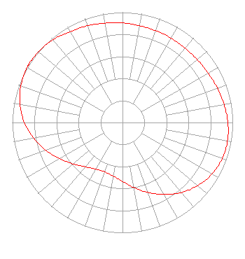 | ||||||||||||||||||
| Azimuth | Ratio | Azimuth | Ratio | Azimuth | Ratio | Azimuth | Ratio | ||||||||||||
| 0 | 0.903 | 10 | 0.891 | 20 | 0.886 | 30 | 0.884 | ||||||||||||
| 40 | 0.881 | 50 | 0.886 | 60 | 0.895 | 70 | 0.915 | ||||||||||||
| 80 | 0.936 | 90 | 0.956 | 100 | 0.967 | 110 | 0.962 | ||||||||||||
| 120 | 0.936 | 130 | 0.891 | 140 | 0.829 | 150 | 0.752 | ||||||||||||
| 160 | 0.674 | 170 | 0.599 | 180 | 0.535 | 190 | 0.493 | ||||||||||||
| 200 | 0.476 | 210 | 0.487 | 220 | 0.525 | 230 | 0.583 | ||||||||||||
| 240 | 0.656 | 250 | 0.739 | 260 | 0.818 | 270 | 0.891 | ||||||||||||
| 280 | 0.945 | 290 | 0.981 | 300 | 0.998 | 302 | 1.000 | ||||||||||||
| 310 | 0.995 | 320 | 0.981 | 330 | 0.948 | 340 | 0.934 | ||||||||||||
| 350 | 0.915 | ||||||||||||||||||
Structure Registration Number 1227743 Structure Type: TOWER Registered To: Hour of Harvest Inc. Structure Address: Approx 3.4 Miles North Of Beattyville, Lee County, Ky. On Hwy 11 Near 700 Tip To Beattyville, KY County Name: Lee County ASR Issued: 07/22/2001 Date Built: 10/03/2002 Site Elevation: 298.7 m (980 ft.) Structure Height: 286.5 m (940 ft.) Height Overall: 304.8 m (1000 ft.) Overall Height AMSL: 603.5 m (1980 ft.) FAA Determination: 06/12/2001 FAA Study #: 01-ASO-3894-OE FAA Circular #: 70/7460-1K Paint & Light FAA Chapters: 3, 4, 5, 12 PRIOR STUDY 00-ASO-9967-OE SUPPLEMENTAL NOTICE STATES STRUCTURE REACHED GREATEST HEIGHT ON 10/03/2002 37-36-47.3 N 83-40-17.6 W (NAD 83) 37-36-47.0 N 83-40-17.9 W (Converted to NAD 27) |
219 Radio Station Loop Beattyville, KY 41311 Phone: 606-464-3600 Corporation | Date: 02/17/2012 Application Certifier HOUR OF HARVEST, INC. Po Box Y Beattyville, KY 41311 Applicant KYLE FISHER 2237 Tacketts Mill Drive Suite A Lakeridge, VA 22192 CONSULTING ENGINEER LEE G. PETRO, ESQUIRE Drinker Biddle & Reath, Llp 1500 K Street, N.w. Suite 1100 Washington, DC 20005 | |||||||||||||||||