
FCCInfo.com
A Service of Cavell, Mertz & Associates, Inc.
(855) FCC-INFO
|
|
K33FO-D from 10/07/1999 |
|
|
||||||||||||||||
|
|
Status: License Application Accepted: 10/17/2008 License Expires: 06/01/2022 File Number: BLDTT-20081017AEB Prefix Type: This is BLDTT FCC Website Links: LMS Facility Details This Application Other K33FO-D Applications Including Superseded Applications Mailing Address Correspondence for K33FO-D Correspondence related to application BLDTT-20081017AEB Service Contour - Open Street Map or USGS Map (51 dBu) Service Contour - KML / Google Earth (51 dBu) Rabbit Ears Info Search for K33FO-D Site Location: 40-04-27.0 N 101-23-33.0 W (NAD 83) Site Location: 40-04-27.0 N 101-23-31.4 W (Converted to NAD 27) ERP: 15 kW R/C AGL: 95 m (312 ft.) R/C AMSL: 1040 m (3412 ft.) Emission Mask: Simple Site Elevation: 945 m. (3100 ft.) Height Overall*: 101 m (331 ft.) (* As Filed In This Application, may differ from ASR Data, Below.) Directional Antenna - Antenna Make/Model: Bogner B16UH Antenna ID: 18060
| ||||||||||||||||||
| Antenna Data for Antenna Id: 18060 K33FO-D LD File: BLDTT-20081017AEB Bogner - B16UH Service: LD Standard Pattern: Y Pattern and Field Values Include a 70° Clockwise Rotation | 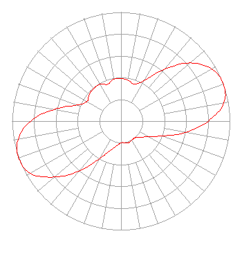 | ||||||||||||||||||
| Azimuth | Ratio | Azimuth | Ratio | Azimuth | Ratio | Azimuth | Ratio | ||||||||||||
| 0 | 0.390 | 10 | 0.380 | 20 | 0.360 | 30 | 0.430 | ||||||||||||
| 40 | 0.620 | 50 | 0.830 | 60 | 0.960 | 70 | 1.000 | ||||||||||||
| 80 | 0.960 | 90 | 0.800 | 100 | 0.600 | 110 | 0.400 | ||||||||||||
| 120 | 0.290 | 130 | 0.230 | 140 | 0.200 | 150 | 0.200 | ||||||||||||
| 160 | 0.210 | 170 | 0.200 | 180 | 0.200 | 190 | 0.230 | ||||||||||||
| 200 | 0.290 | 210 | 0.400 | 220 | 0.600 | 230 | 0.800 | ||||||||||||
| 240 | 0.960 | 250 | 1.000 | 260 | 0.960 | 270 | 0.830 | ||||||||||||
| 280 | 0.620 | 290 | 0.430 | 300 | 0.360 | 310 | 0.380 | ||||||||||||
| 320 | 0.390 | 330 | 0.390 | 340 | 0.360 | 350 | 0.390 | ||||||||||||
Structure Registration Number 1027243 Structure Type: TOWER Registered To: Nebraska Educational Telecommunications Commission Structure Address: 4 Km S Max, NE County Name: Dundy County ASR Issued: 05/08/2023 Date Built: 10/01/1993 Site Elevation: 944.8 m (3100 ft.) Structure Height: 94.5 m (310 ft.) Height Overall: 100.6 m (330 ft.) Overall Height AMSL: 1045.4 m (3430 ft.) FAA Determination: 04/19/1995 FAA Study #: 93-ACE-0561-OE FAA Circular #: 70/7460-1H Paint & Light FAA Chapters: 4, 6, 13 40-04-27.0 N 101-23-33.0 W (NAD 83) 40-04-27.0 N 101-23-31.4 W (Converted to NAD 27) |
1800 N. 33rd Street Lincoln, NE 68503 Phone: 402-472-9333 Government Entity | Date: 10/17/2008 Application Certifier NEBRASKA EDUCATIONAL TELECOMMUNICATIONS COMMISSION 1800 N. 33rd Street Lincoln, NE 68503 Applicant ROGER L. BOOK 1800 North 33rd St. Lincoln, NE 68503 EMPLOYEE BARRY PERSH Dow Lohnes Pllc | |||||||||||||||||