
FCCInfo.com
A Service of Cavell, Mertz & Associates, Inc.
(855) FCC-INFO
|
|
|
|
|
||||||||||||||||
|
|
Status: License Application Accepted: 02/24/2014 License Expires: 04/01/2022 File Number: BLDTT-20140224ACZ Prefix Type: This is BLDTT FCC Website Links: LMS Facility Details This Application Other K21HX-D Applications Including Superseded Applications Mailing Address Correspondence for K21HX-D Correspondence related to application BLDTT-20140224ACZ Service Contour - Open Street Map or USGS Map (51 dBu) Service Contour - KML / Google Earth (51 dBu) Rabbit Ears Info Search for K21HX-D Site Location: 47-05-36.0 N 94-34-48.0 W (NAD 83) Site Location: 47-05-36.2 N 94-34-47.0 W (Converted to NAD 27) ERP: 3.3 kW R/C AGL: 124.1 m (407 ft.) R/C AMSL: 576.8 m (1892 ft.) Emission Mask: Stringent Site Elevation: 452.7 m. (1485 ft.) Height Overall*: 126.3 m (414 ft.) (* As Filed In This Application, may differ from ASR Data, Below.) Directional Antenna - Antenna Make/Model: Kathrein 771304 Antenna ID: 114706
| ||||||||||||||||||
| Antenna Data for Antenna Id: 114706 K21HX-D LD File: BLDTT-20140224ACZ Kathrein - 771304 Service: LD Standard Pattern: Y Pattern and Field Values Include a 340° Clockwise Rotation | 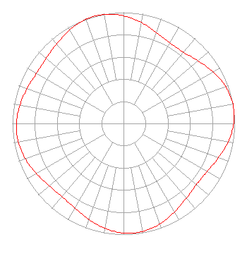 | ||||||||||||||||||
| Azimuth | Ratio | Azimuth | Ratio | Azimuth | Ratio | Azimuth | Ratio | ||||||||||||
| 0 | 0.969 | 10 | 0.922 | 20 | 0.870 | 30 | 0.837 | ||||||||||||
| 40 | 0.838 | 50 | 0.876 | 60 | 0.930 | 70 | 0.977 | ||||||||||||
| 80 | 1.000 | 90 | 0.991 | 100 | 0.956 | 110 | 0.908 | ||||||||||||
| 120 | 0.868 | 130 | 0.857 | 140 | 0.879 | 150 | 0.919 | ||||||||||||
| 160 | 0.962 | 170 | 0.988 | 180 | 0.986 | 190 | 0.959 | ||||||||||||
| 200 | 0.917 | 210 | 0.877 | 220 | 0.861 | 230 | 0.873 | ||||||||||||
| 240 | 0.904 | 250 | 0.939 | 260 | 0.962 | 270 | 0.963 | ||||||||||||
| 280 | 0.946 | 290 | 0.922 | 300 | 0.904 | 310 | 0.909 | ||||||||||||
| 320 | 0.936 | 330 | 0.970 | 340 | 0.996 | 350 | 0.996 | ||||||||||||
Structure Registration Number 1025256 Structure Type: TOWER Registered To: LEECH LAKE TV CORPORATION Structure Address: .5 Mi S Walker, MN County Name: Cass County ASR Issued: 03/13/2014 Date Built: 01/01/1962 Site Elevation: 452.7 m (1485 ft.) Structure Height: 122 m (400 ft.) Height Overall: 126.3 m (414 ft.) Overall Height AMSL: 579 m (1900 ft.) FAA Determination: 08/25/1997 FAA Study #: 97-AGL-3597-OE FAA Circular #: 70/7460-1J Paint & Light FAA Chapters: 3, 4, 5, 13 47-05-36.0 N 94-34-48.0 W (NAD 83) 47-05-36.2 N 94-34-47.0 W (Converted to NAD 27) |
Box 493 Walker, MN 56484 Phone: 218-224-3195 Applicant | Date: 02/24/2014 Application Certifier LEECH LAKE TELEVISION CORPORATION Box 493 Walker, MN 56484 Applicant B. W. ST. CLAIR 2355 Ranch Drive Westminster, CO 80234 ENGINEERING CONSULTANT TERRY HOLLY Leech Lake Television Corporation | |||||||||||||||||