
FCCInfo.com
A Service of Cavell, Mertz & Associates, Inc.
(855) FCC-INFO
|
|
K09TH-D from 05/18/1982 |
|
|
||||||||||||||||
|
|
Status: License Application Accepted: 10/21/2009 License Expires: 04/01/2022 File Number: BLDTV-20091021ABR Prefix Type: This is BLDTV FCC Website Links: LMS Facility Details This Application Other K09TH-D Applications Including Superseded Applications Mailing Address Correspondence for K09TH-D Correspondence related to application BLDTV-20091021ABR Service Contour - Open Street Map or USGS Map (48 dBu) Service Contour - KML / Google Earth (48 dBu) Rabbit Ears Info Search for K09TH-D Site Location: 38-31-41.4 N 106-54-16.7 W (NAD 83) Site Location: 38-31-41.4 N 106-54-14.5 W (Converted to NAD 27) ERP: 0.055 kW R/C AGL: 9.1 m (30 ft.) R/C AMSL: 2636.1 m (8649 ft.) Emission Mask: Simple Site Elevation: 2627 m. (8619 ft.) Height Overall*: 9.2 m (30 ft.) (* As Filed In This Application, may differ from ASR Data, Below.) Directional Antenna - Antenna Make/Model: Scala ODDK09TH Antenna ID: 95841
| ||||||||||||||||||
| Antenna Data for Antenna Id: 95841 K09TH-D LD File: BLDTV-20091021ABR Scala - ODDK09TH Service: LD Standard Pattern: Y | 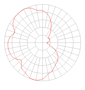 | ||||||||||||||||||
| Azimuth | Ratio | Azimuth | Ratio | Azimuth | Ratio | Azimuth | Ratio | ||||||||||||
| 0 | 0.833 | 10 | 0.754 | 20 | 0.619 | 30 | 0.446 | ||||||||||||
| 40 | 0.318 | 50 | 0.190 | 60 | 0.203 | 70 | 0.203 | ||||||||||||
| 80 | 0.176 | 90 | 0.121 | 100 | 0.129 | 110 | 0.217 | ||||||||||||
| 120 | 0.379 | 130 | 0.518 | 140 | 0.613 | 150 | 0.673 | ||||||||||||
| 160 | 0.769 | 170 | 0.840 | 180 | 0.949 | 190 | 0.995 | ||||||||||||
| 200 | 0.975 | 210 | 0.904 | 220 | 0.857 | 230 | 0.725 | ||||||||||||
| 240 | 0.833 | 250 | 0.894 | 260 | 0.907 | 270 | 0.904 | ||||||||||||
| 280 | 0.857 | 290 | 0.772 | 300 | 0.894 | 310 | 0.967 | ||||||||||||
| 320 | 0.988 | 330 | 0.998 | 340 | 0.959 | 350 | 0.860 | ||||||||||||
Structure Registration Number 1269244 Structure Type: POLE Registered To: Gunnison County Metropolitan Recreation District Structure Address: 1.5 Miles South East Of The Gunnison Airport Gunnison, CO County Name: Gunnison County ASR Issued: 07/28/2009 Site Elevation: 2626.8 m (8618 ft.) Structure Height: 9.1 m (30 ft.) Height Overall: 9.1 m (30 ft.) Overall Height AMSL: 2635.9 m (8648 ft.) FAA Determination: 01/10/2007 FAA Study #: 2006-ANM-4525-OE FAA Circular #: Paint & Light FAA Chapters: NONE PRIOR STUDY 2003-ANM-531-OE 38-31-41.4 N 106-54-16.7 W (NAD 83) 38-31-41.4 N 106-54-14.5 W (Converted to NAD 27) |
Po Box 1369 Gunnison, CO 81230 Phone: 970-641-8725 Applicant | Date: 10/21/2009 Application Certifier GUNNISON COUNTY METROPOLITAN RECREATION DISTRICT Po Box 1369 Gunnison, CO 81230 Applicant B. W. ST. CLAIR 2355 Ranch Drive Westminster, CO 80234 ENGINEERING CONSULTANT GUNNISON COUNTY METROPOLITAN RECREATION DISTRICT | |||||||||||||||||
| |||||||||||||||||||