
FCCInfo.com
A Service of Cavell, Mertz & Associates, Inc.
(855) FCC-INFO
|
|
|
Virtual Channel 8 |  |
|
|||||||||||||||||||||
|
|
Status: License Application Accepted: 11/06/2013 License Expires: 06/01/2022 File Number: BLEDT-20131106AHP Prefix Type: This is a license for a noncommercial educational digital TV station FCC Website Links: LMS Facility Details This Application Other KPTS Applications Including Superseded Applications Mailing Address Correspondence for KPTS Correspondence related to application BLEDT-20131106AHP Service Contour - Open Street Map or USGS Map (51 dBu) Service Contour - KML / Google Earth (51 dBu) History Cards for KPTS Rabbit Ears Info Search for KPTS Site Location: 37-48-13.9 N 97-20-55.4 W (NAD 83) Site Location: 37-48-13.9 N 97-20-54.2 W (Converted to NAD 27) ERP: 13.7 kW Electrical Beam Tilt: 1 degree R/C AGL: 129.5 m (425 ft.) R/C AMSL: 544 m (1785 ft.) Emission Mask: Stringent Site Elevation: 414.5 m. (1360 ft.) Height Overall*: 148.7 m (488 ft.) (* As Filed In This Application, may differ from ASR Data, Below.) Directional Antenna - Antenna Make/Model: Andrew ALP160C Antenna ID: 16496 | ||||||||||||||||||||||||
| Antenna Data for Antenna Id: 16496 KPTS LD File: BLEDT-20131106AHP Andrew - ALP160C Service: LD Standard Pattern: Y Pattern and Field Values Include a 180° Clockwise Rotation | 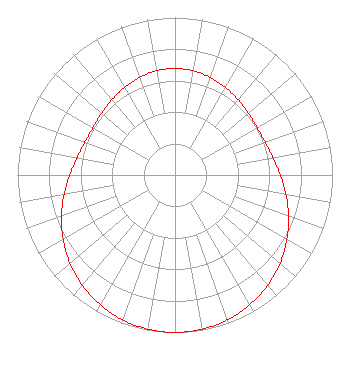 | ||||||||||||||||||||||||
| Azimuth | Ratio | Azimuth | Ratio | Azimuth | Ratio | Azimuth | Ratio | ||||||||||||||||||
| 0 | 0.676 | 10 | 0.672 | 20 | 0.659 | 30 | 0.642 | ||||||||||||||||||
| 40 | 0.623 | 50 | 0.608 | 60 | 0.602 | 70 | 0.609 | ||||||||||||||||||
| 80 | 0.631 | 90 | 0.668 | 100 | 0.715 | 110 | 0.767 | ||||||||||||||||||
| 120 | 0.820 | 130 | 0.871 | 140 | 0.915 | 150 | 0.951 | ||||||||||||||||||
| 160 | 0.978 | 170 | 0.994 | 180 | 1.000 | 190 | 0.994 | ||||||||||||||||||
| 200 | 0.978 | 210 | 0.951 | 220 | 0.915 | 230 | 0.871 | ||||||||||||||||||
| 240 | 0.820 | 250 | 0.767 | 260 | 0.715 | 270 | 0.668 | ||||||||||||||||||
| 280 | 0.631 | 290 | 0.609 | 300 | 0.602 | 310 | 0.608 | ||||||||||||||||||
| 320 | 0.623 | 330 | 0.642 | 340 | 0.659 | 350 | 0.672 | ||||||||||||||||||
Structure Registration Number 1288320 [ASR Heights Differ from KPTS Application] Structure Type: GTOWER Registered To: Kansas Public Telecommunications Service, Inc. Structure Address: N.w.1/4 Section 8 Twp 26 S.r.e. Park City, KS County Name: Sedgwick County ASR Issued: 07/25/2013 Date Built: 10/21/2013 Site Elevation: 407.8 m (1338 ft.) Structure Height: 137.2 m (450 ft.) Height Overall: 138.7 m (455 ft.) Overall Height AMSL: 546.5 m (1793 ft.) FAA Determination: 03/21/2013 FAA Study #: 2013-ACE-200-OE FAA Circular #: 70/7460-1K Paint & Light FAA Chapters: 4, 8, 12 Removed expiration date from determination. Scenario 1./jjs/case#635066 37-48-13.9 N 97-20-55.4 W (NAD 83) 37-48-13.9 N 97-20-54.2 W (Converted to NAD 27) |
320 W. 21st Street N. Wichita, KS 67203 Phone: 316-838-3090 Not-for-Profit | Date: 11/06/2013 Application Certifier KANSAS PUBLIC TELECOMMUNICATIONS SERVICE, INC. 320 W. 21st Street N Wichita, KS 67203-2499 Applicant GREGORY L BEST 9223 N. Manning Avenue Kansas City, MO 64157 CONSULTING ENGINEER DAVE MCCLINTOCK Kansas Public Telecommunications Service, Inc. | |||||||||||||||||||||||
|
| ||||||||||||||||||||||||
