
FCCInfo.com
A Service of Cavell, Mertz & Associates, Inc.
(855) FCC-INFO
|
|
K07YJ-D from 03/31/2006 |
|
|
||||||||||||||||
|
|
Status: License Application Accepted: 03/08/2013 License Expires: 10/01/2022 File Number: BLDTV-20130308AAN Prefix Type: This is BLDTV FCC Website Links: LMS Facility Details This Application Other K07YJ-D Applications Including Superseded Applications Mailing Address Correspondence for K07YJ-D Correspondence related to application BLDTV-20130308AAN Service Contour - Open Street Map or USGS Map (48 dBu) Service Contour - KML / Google Earth (48 dBu) Rabbit Ears Info Search for K07YJ-D Site Location: 35-12-46.0 N 114-33-21.0 W (NAD 83) Site Location: 35-12-46.0 N 114-33-18.1 W (Converted to NAD 27) ERP: 0.06 kW R/C AGL: 6.1 m (20 ft.) R/C AMSL: 323.1 m (1060 ft.) Emission Mask: Stringent Site Elevation: 317 m. (1040 ft.) Height Overall*: 7.6 m (25 ft.) (* As Filed In This Application, may differ from ASR Data, Below.) Directional Antenna - Antenna Make/Model: Scala HDCA5 Antenna ID: 20829
| ||||||||||||||||||
| Antenna Data for Antenna Id: 20829 K07YJ-D LD File: BLDTV-20130308AAN Scala - HDCA5 Service: LD Standard Pattern: Y Pattern and Field Values Include a 170° Clockwise Rotation | 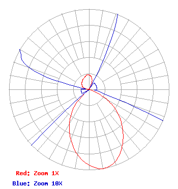 | ||||||||||||||||||
| Azimuth | Ratio | Azimuth | Ratio | Azimuth | Ratio | Azimuth | Ratio | ||||||||||||
| 0 | 0.180 | 10 | 0.160 | 20 | 0.110 | 30 | 0.010 | ||||||||||||
| 40 | 0.010 | 50 | 0.010 | 60 | 0.010 | 70 | 0.010 | ||||||||||||
| 80 | 0.010 | 90 | 0.010 | 100 | 0.010 | 110 | 0.050 | ||||||||||||
| 120 | 0.270 | 130 | 0.475 | 140 | 0.655 | 150 | 0.825 | ||||||||||||
| 160 | 0.955 | 170 | 1.000 | 180 | 0.940 | 190 | 0.824 | ||||||||||||
| 200 | 0.664 | 210 | 0.490 | 220 | 0.290 | 230 | 0.010 | ||||||||||||
| 240 | 0.010 | 250 | 0.010 | 260 | 0.010 | 270 | 0.010 | ||||||||||||
| 280 | 0.010 | 290 | 0.080 | 300 | 0.100 | 310 | 0.119 | ||||||||||||
| 320 | 0.130 | 330 | 0.148 | 340 | 0.160 | 350 | 0.180 | ||||||||||||
Structure Registration Number 1276290 [ASR Heights Differ from K07YJ-D Application] Structure Type: TOWER Registered To: Mohave County Board of Supervisors Structure Address: Katherine's Landing Bullhead City, AZ County Name: Mohave County ASR Issued: 05/18/2012 Date Built: 01/01/1972 Site Elevation: 359.7 m (1180 ft.) Structure Height: 7.6 m (25 ft.) Height Overall: 7.6 m (25 ft.) Overall Height AMSL: 367.3 m (1205 ft.) FAA Determination: 04/26/2012 FAA Study #: 2012-AWP-2740-OE Paint & Light FAA Chapters: NONE PRIOR STUDY 2010-AWP-7246-OE 35-12-46.0 N 114-33-21.0 W (NAD 83) 35-12-46.0 N 114-33-18.1 W (Converted to NAD 27) |
Po Box 7000 Kingman, AZ 86402 Phone: 928-753-0729 Government Entity | Date: 03/08/2013 Application Certifier MOHAVE COUNTY BOARD OF SUPERVISORS P.o. Box 7000 Kingman, AZ 86402-7000 Applicant LOUIS R DUTREIL JR Dutreil Lundin & Rackley Inc 201 Fletcher Ave Sarasota, FL 34237-6019 CONSULTING ENGINEER WILLIAM K. KEANE Duane Morris Llp | |||||||||||||||||