
FCCInfo.com
A Service of Cavell, Mertz & Associates, Inc.
(855) FCC-INFO
|
|
|
|
|
||||||||||||||||
|
|
Status: License Application Accepted: 04/06/2011 License Expires: 10/01/2022 File Number: BLDTT-20110406ABR Prefix Type: This is BLDTT FCC Website Links: LMS Facility Details This Application Other K35KL-D Applications Including Superseded Applications Mailing Address Correspondence for K35KL-D Correspondence related to application BLDTT-20110406ABR Service Contour - Open Street Map or USGS Map (51 dBu) Service Contour - KML / Google Earth (51 dBu) Rabbit Ears Info Search for K35KL-D Site Location: 40-57-33.5 N 109-25-01.5 W (NAD 83) Site Location: 40-57-33.6 N 109-24-59.0 W (Converted to NAD 27) ERP: 0.089 kW R/C AGL: 9.1 m (30 ft.) R/C AMSL: 2188.1 m (7179 ft.) Emission Mask: Simple Site Elevation: 2179 m. (7149 ft.) Height Overall*: 14 m (46 ft.) (* As Filed In This Application, may differ from ASR Data, Below.) Directional Antenna - Antenna Make/Model: Scala 1X2KBBU Antenna ID: 20718
| ||||||||||||||||||
| Antenna Data for Antenna Id: 20718 K35KL-D LD File: BLDTT-20110406ABR Scala - 1X2KBBU Service: LD Standard Pattern: Y Pattern and Field Values Include a 260° Clockwise Rotation | 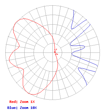 | ||||||||||||||||||
| Azimuth | Ratio | Azimuth | Ratio | Azimuth | Ratio | Azimuth | Ratio | ||||||||||||
| 0 | 0.316 | 10 | 0.202 | 20 | 0.131 | 30 | 0.089 | ||||||||||||
| 40 | 0.065 | 50 | 0.116 | 60 | 0.051 | 70 | 0.043 | ||||||||||||
| 80 | 0.069 | 90 | 0.043 | 100 | 0.051 | 110 | 0.116 | ||||||||||||
| 120 | 0.065 | 130 | 0.089 | 140 | 0.131 | 150 | 0.202 | ||||||||||||
| 160 | 0.316 | 170 | 0.432 | 180 | 0.570 | 190 | 0.738 | ||||||||||||
| 200 | 0.931 | 210 | 1.000 | 220 | 0.955 | 230 | 0.813 | ||||||||||||
| 240 | 0.717 | 250 | 0.846 | 260 | 0.931 | 270 | 0.846 | ||||||||||||
| 280 | 0.717 | 290 | 0.813 | 300 | 0.955 | 310 | 1.000 | ||||||||||||
| 320 | 0.931 | 330 | 0.738 | 340 | 0.570 | 350 | 0.432 | ||||||||||||
Structure Registration Number 1237507 [ASR Heights Differ from K35KL-D Application] Structure Type: LTOWER Registered To: University of Utah Structure Address: Aprox 2 Miles North Of Dutch John, Utah Dutch John, UT County Name: Daggett County ASR Issued: 11/06/2012 Date Built: 10/01/2003 Site Elevation: 2182.7 m (7161 ft.) Structure Height: 7.3 m (24 ft.) Height Overall: 12.8 m (42 ft.) Overall Height AMSL: 2195.5 m (7203 ft.) FAA Determination: 08/21/2011 FAA Study #: 2011-ANM-1463-OE Paint & Light FAA Chapters: NONE PRIOR STUDY 2000-ANM-1275-OE 40-57-33.5 N 109-25-01.5 W (NAD 83) 40-57-33.6 N 109-24-59.0 W (Converted to NAD 27) |
101 S. Wasatch Drive Room 215 Salt Lake City, UT 84112 Phone: 501-585-1601 Government Entity | Date: 04/06/2011 Application Certifier UNIVERSITY OF UTAH 101 S. Wasatch Drive Room 215 Salt Lake City, UT 84112 Applicant RON TITCOMB 4570 Lake Creek Road Heber City, UT 84032 CONSULTING ENGINEER PHILIP ALAN TITUS | |||||||||||||||||