
FCCInfo.com
A Service of Cavell, Mertz & Associates, Inc.
(855) FCC-INFO
|
|
|
|
|
||||||||||||||||
|
|
Status: License Application Accepted: 12/16/2011 License Expires: 10/01/2022 File Number: BLDTV-20111216ABM Prefix Type: This is BLDTV FCC Website Links: LMS Facility Details This Application Other K06HT-D Applications Including Superseded Applications Mailing Address Correspondence for K06HT-D Correspondence related to application BLDTV-20111216ABM Service Contour - Open Street Map or USGS Map (43 dBu) Service Contour - KML / Google Earth (43 dBu) Rabbit Ears Info Search for K06HT-D Site Location: 39-15-52.8 N 114-53-38.1 W (NAD 83) Site Location: 39-15-53.0 N 114-53-35.0 W (Converted to NAD 27) ERP: 0.053 kW R/C AGL: 5 m (16 ft.) R/C AMSL: 2396 m (7861 ft.) Emission Mask: Simple Site Elevation: 2391 m. (7844 ft.) Height Overall*: 9.1 m (30 ft.) (* As Filed In This Application, may differ from ASR Data, Below.) Directional Antenna - Antenna Make/Model: Scala ODD K06HT Antenna ID: 104445
| ||||||||||||||||||
| Antenna Data for Antenna Id: 104445 K06HT-D LD File: BLDTV-20111216ABM Scala - ODD K06HT Service: LD Standard Pattern: Y | 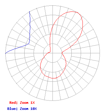 | ||||||||||||||||||
| Azimuth | Ratio | Azimuth | Ratio | Azimuth | Ratio | Azimuth | Ratio | ||||||||||||
| 0 | 0.548 | 10 | 0.754 | 20 | 0.906 | 30 | 0.987 | ||||||||||||
| 33 | 1.000 | 40 | 0.956 | 50 | 0.832 | 60 | 0.650 | ||||||||||||
| 70 | 0.430 | 80 | 0.252 | 90 | 0.198 | 100 | 0.223 | ||||||||||||
| 110 | 0.270 | 120 | 0.322 | 130 | 0.373 | 140 | 0.414 | ||||||||||||
| 150 | 0.453 | 160 | 0.497 | 170 | 0.526 | 175 | 0.532 | ||||||||||||
| 180 | 0.530 | 190 | 0.512 | 200 | 0.495 | 210 | 0.456 | ||||||||||||
| 220 | 0.398 | 230 | 0.318 | 240 | 0.232 | 250 | 0.167 | ||||||||||||
| 260 | 0.126 | 270 | 0.099 | 280 | 0.070 | 290 | 0.055 | ||||||||||||
| 300 | 0.056 | 310 | 0.063 | 320 | 0.074 | 330 | 0.097 | ||||||||||||
| 340 | 0.152 | 350 | 0.307 | ||||||||||||||||
Structure Registration Number 1276630 Structure Type: POLE Registered To: WHITE PINE TELEVISION DISTRICT #1 Structure Address: Squaw Peak Ely, NV County Name: White Pine County ASR Issued: 11/05/2010 Site Elevation: 2391.2 m (7845 ft.) Structure Height: 9.1 m (30 ft.) Height Overall: 9.1 m (30 ft.) Overall Height AMSL: 2400.3 m (7875 ft.) FAA Determination: 10/14/2010 FAA Study #: 2010-AWP-6141-OE FAA Circular #: Paint & Light FAA Chapters: NONE Removed expiration date from determination. Scenario 1./jjs/case#635066 39-15-52.8 N 114-53-38.1 W (NAD 83) 39-15-53.0 N 114-53-35.0 W (Converted to NAD 27) |
Po Box 151704 Ely, NV 89315 Phone: 775-289-4048 Applicant | Date: 12/16/2011 Application Certifier WHITE PINE TELEVISION DISTRICT #1 P.o. Box 151704 Ely, NV 89315 Applicant B. W. ST. CLAIR 2355 Ranch Drive Westminster, CO 80234 ENGINEERING CONSULTANT JOSEPH R. CHRISTENSEN White Pine Television District #1 | |||||||||||||||||