
FCCInfo.com
A Service of Cavell, Mertz & Associates, Inc.
(855) FCC-INFO
|
|
WGVT-LD from 11/27/2006 WGVT-LD from 01/23/2004 |
|
|
||||||||||||||||
|
|
Status: License (Licensed And Silent) Application Accepted: 06/05/2008 License Expires: 02/01/2021 File Number: BLDTL-20080605AAQ Prefix Type: This is BLDTL FCC Website Links: LMS Facility Details This Application Other WGVT-LD Applications Including Superseded Applications Mailing Address Correspondence for WGVT-LD Correspondence related to application BLDTL-20080605AAQ Service Contour - Open Street Map or USGS Map (51 dBu) Service Contour - KML / Google Earth (51 dBu) Rabbit Ears Info Search for WGVT-LD Site Location: 29-44-23.0 N 82-23-08.0 W (NAD 83) Site Location: 29-44-22.1 N 82-23-08.6 W (Converted to NAD 27) ERP: 15 kW R/C AGL: 129 m (423 ft.) R/C AMSL: 181 m (594 ft.) Emission Mask: Stringent Site Elevation: 52 m. (171 ft.) Height Overall*: 145 m (476 ft.) (* As Filed In This Application, may differ from ASR Data, Below.) Directional Antenna - Antenna Make/Model: Systems With Reliability Inc. SWLP8MC SPECIAL Antenna ID: 81222 | ||||||||||||||||||
| Antenna Data for Antenna Id: 81222 WGVT-LD LD File: BLDTL-20080605AAQ Systems With Reliability Inc. - SWLP8MC SPECIAL Service: LD Standard Pattern: Y Pattern and Field Values Include a 300° Clockwise Rotation | 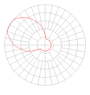 | ||||||||||||||||||
| Azimuth | Ratio | Azimuth | Ratio | Azimuth | Ratio | Azimuth | Ratio | ||||||||||||
| 0 | 0.250 | 10 | 0.150 | 20 | 0.150 | 30 | 0.150 | ||||||||||||
| 40 | 0.150 | 50 | 0.150 | 60 | 0.150 | 70 | 0.150 | ||||||||||||
| 80 | 0.150 | 90 | 0.150 | 100 | 0.150 | 110 | 0.150 | ||||||||||||
| 120 | 0.150 | 130 | 0.150 | 140 | 0.150 | 150 | 0.150 | ||||||||||||
| 160 | 0.150 | 170 | 0.150 | 180 | 0.150 | 190 | 0.150 | ||||||||||||
| 200 | 0.150 | 210 | 0.150 | 220 | 0.150 | 230 | 0.150 | ||||||||||||
| 240 | 0.250 | 250 | 0.460 | 260 | 0.600 | 270 | 0.760 | ||||||||||||
| 280 | 0.880 | 290 | 0.990 | 300 | 1.000 | 310 | 0.990 | ||||||||||||
| 320 | 0.880 | 330 | 0.760 | 340 | 0.600 | 350 | 0.460 | ||||||||||||
Structure Registration Number 1029137 [ASR Heights Differ from WGVT-LD Application] Structure Type: GTOWER Registered To: TOWER PROPERTIES OF FLORIDA, INC. Structure Address: 4150 Nw 93 Ave Gainesville, FL County Name: Alachua County ASR Issued: 03/25/2020 Date Built: 04/10/2020 Site Elevation: 51.8 m (170 ft.) Structure Height: 150.6 m (494 ft.) Height Overall: 150.6 m (494 ft.) Overall Height AMSL: 202.4 m (664 ft.) FAA Determination: 03/12/2020 FAA Study #: 2020-ASO-5728-OE FAA Circular #: 70/7460-1L Paint & Light FAA Chapters: 3, 4, 5, 12 PRIOR STUDY 1995-ASO-1138-OE 29-44-24.0 N 82-23-11.7 W (NAD 83) 29-44-23.1 N 82-23-12.3 W (Converted to NAD 27) |
4150 Nw 93rd Ave. Gainesville, FL 32653 Phone: 352-371-7772 Corporation | Date: 06/05/2008 Application Certifier BUDD BROADCASTING CO., INC. 4150 N.w. 93rd Ave Gainesville, FL 32653 Applicant RICHARD C GOETZ 135 N Country Club Drive Hendersonville, TN 37075 BROADCAST CONSULTANT AARON P. SHAINIS Shainis & Peltzman, Chartered | |||||||||||||||||