
FCCInfo.com
A Service of Cavell, Mertz & Associates, Inc.
(855) FCC-INFO
|
|
W296DK from 11/18/2016 W296DK from 11/16/2016 W296DK from 12/24/2013 |
|
|
||||||||||||||||
|
|
W296DK Channel: 296D 107.1 MHz Fort Lauderdale, Florida Service: FX - A translator or application for a translator. Facility ID: 142174 Fac. Service: FX Programming Delivery Method: Unspecified Status: License Application Accepted: 09/24/2018 Application Granted: 10/05/2018 File Number: BLFT-20180924AAX License Expires: 02/01/2028 Prefix Type: This is a license for a translator Application Type: License To Cover FCC Website Links: LMS Facility Details This Application CDBS Application Other W296DK Applications Other W296DK Applications in CDBS Including Superseded Applications Mailing Address Correspondence for W296DK Correspondence related to application BLFT-20180924AAX Service Contour - Open Street Map or USGS Map (60 dBu) Service Contour - KML / Google Earth (60 dBu) Class: D, A Noncommercial educational operating with no more than 10W Site Location: 25-58-16.0 N 80-12-31.0 W (NAD 83) Site Location: 25-58-14.7 N 80-12-31.8 W (Converted to NAD 27) Effective Radiated Power: 0 kW Horiz. ; 0.099 kW Vert. Transmitter Output Power: 0.059 kW Antenna Center HAAT: 0 m Antenna Center AMSL: 0 m Horiz.; 261 m Vert. Antenna Center HAG: 0 m Horiz.; 259 m Vert. Site Elevation: 2 m. (7 ft.) Height Overall*: 318 m (1043 ft.) (* As Filed In This Application, may differ from ASR Data, Below.) Directional Antenna Antenna Make/Model: Scala CA2-FM X2 Antenna ID: 132135 Polarization: H
| ||||||||||||||||||
| Antenna Data for Antenna Id: 132135 W296DK FX File: BLFT-20180924AAX Scala - CA2-FM X2 Service: FX | 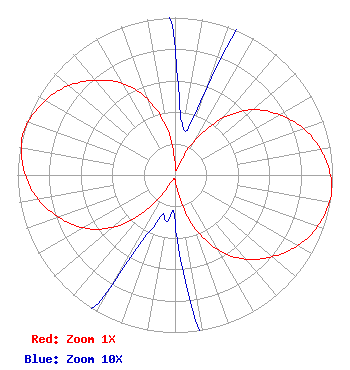 | ||||||||||||||||||
| Azimuth | Ratio | Azimuth | Ratio | Azimuth | Ratio | Azimuth | Ratio | ||||||||||||
| 0 | 0.080 | 10 | 0.030 | 20 | 0.060 | 30 | 0.257 | ||||||||||||
| 40 | 0.473 | 50 | 0.644 | 60 | 0.765 | 70 | 0.866 | ||||||||||||
| 80 | 0.939 | 90 | 0.986 | 97 | 1.000 | 100 | 0.994 | ||||||||||||
| 110 | 0.962 | 120 | 0.898 | 130 | 0.807 | 140 | 0.698 | ||||||||||||
| 150 | 0.549 | 160 | 0.347 | 170 | 0.122 | 180 | 0.030 | ||||||||||||
| 190 | 0.030 | 200 | 0.030 | 210 | 0.080 | 220 | 0.305 | ||||||||||||
| 230 | 0.515 | 240 | 0.672 | 250 | 0.785 | 260 | 0.883 | ||||||||||||
| 270 | 0.950 | 280 | 0.990 | 285 | 1.000 | 290 | 0.990 | ||||||||||||
| 300 | 0.950 | 310 | 0.883 | 320 | 0.785 | 330 | 0.672 | ||||||||||||
| 340 | 0.515 | 350 | 0.305 | ||||||||||||||||
Structure Registration Number 1027529 [ASR Heights Differ from W296DK Application] Structure Type: TOWER Registered To: INDUSTRIAL COMMUNICATIONS & ELECTRONICS, INC. Structure Address: 350 Nw 215th Street North Miami, FL County Name: Miami-Dade County ASR Issued: 07/20/2000 Date Built: 07/03/1991 Site Elevation: 1.5 m (5 ft.) Structure Height: 303.5 m (996 ft.) Height Overall: 318.2 m (1044 ft.) Overall Height AMSL: 319.7 m (1049 ft.) FAA Determination: 11/26/1990 FAA Study #: 89-ASO-1111-OE FAA Circular #: 70/7460-1G Paint & Light FAA Chapters: 4, 6, 9 OM&L = 24-HR HI STROBES 25-58-16.0 N 80-12-31.0 W (NAD 83) 25-58-14.7 N 80-12-31.8 W (Converted to NAD 27) |
21005 Madria Cir Boca Raton, FL 33433 Phone: 267-237-2478 Limited Liability Company | Date: 09/24/2018 Application Certifier ACM JCE IV B LLC 426 South River Road Tryon, NC 28782 Applicant DONALD LYNCH 111 Sam Houston Drive Kerrville, TX 78028 TECHNICAL CONSULTANT MILES S. MASON, ESQ. Pillsbury Winthrop Shaw Pittman Llp 1200 Seventeenth Street, Nw Washington, DC 20036 | |||||||||||||||||