
FCCInfo.com
A Service of Cavell, Mertz & Associates, Inc.
(855) FCC-INFO
|
|
WYBL from 07/23/1997 |
|  |
|
|||||||||||||||
|
|
WYBL Channel: 252A 98.3 MHz Ashtabula, Ohio Service: FM - A full-service FM station or application. Facility ID: 87818 Fac. Service: FM Status: License 73.215 Station Application Accepted: 03/21/2016 Application Granted: 04/04/2016 File Number: BLH-20160321ABH License Expires: 00/00/0000 Prefix Type: This is a license for a commercial FM station Application Type: License To Cover FCC Website Links: LMS Facility Details This Application CDBS Application Other WYBL Applications Other WYBL Applications in CDBS Including Superseded Applications Mailing Address Correspondence for WYBL Correspondence related to application BLH-20160321ABH Service Contour - Open Street Map or USGS Map (60 dBu) Service Contour - KML / Google Earth (60 dBu) Public Inspection Files Facility Type: FM STATION Class: A, A Zone I; I-A; or II station; with 0.1kW-6kW ERP and a class contour distance <=28km Site Location: 41-51-14.0 N 80-41-20.0 W (NAD 83) Site Location: 41-51-13.8 N 80-41-20.7 W (Converted to NAD 27) Effective Radiated Power: 4.7 kW Transmitter Output Power: 2.85 kW Antenna Center HAAT: 110.4 m (362 ft.) Antenna Center AMSL: 350.3 m (1149 ft.) Antenna Center HAG: 73.2 m (240 ft.) Site Elevation: 277.1 m. (909 ft.) Height Overall*: 76.2 m (250 ft.) (* As Filed In This Application, may differ from ASR Data, Below.) Directional Antenna Antenna Make/Model: Systems With Reliability Inc. FMECR/3-PLUS-HWS-DA, 3 bays, 0.5 wavelength Antenna ID: 121278 Polarization: | ||||||||||||||||||
| Antenna Data for Antenna Id: 121278 WYBL FM File: BLH-20160321ABH Systems With Reliability Inc. - FMECR/3-PLUS-HWS-DA, 3 bays, 0.5 wavelength Service: FM | 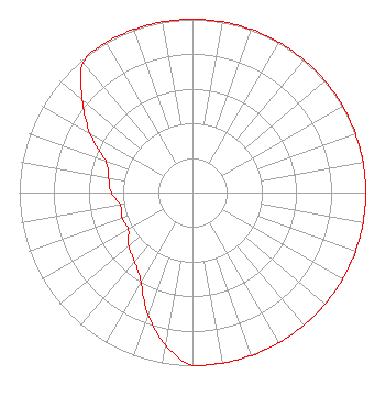 | ||||||||||||||||||
| Azimuth | Ratio | Azimuth | Ratio | Azimuth | Ratio | Azimuth | Ratio | ||||||||||||
| 0 | 1.000 | 10 | 1.000 | 20 | 1.000 | 30 | 1.000 | ||||||||||||
| 40 | 1.000 | 50 | 1.000 | 60 | 1.000 | 70 | 1.000 | ||||||||||||
| 80 | 1.000 | 90 | 1.000 | 100 | 1.000 | 110 | 1.000 | ||||||||||||
| 120 | 1.000 | 130 | 1.000 | 140 | 1.000 | 150 | 1.000 | ||||||||||||
| 160 | 1.000 | 170 | 1.000 | 180 | 1.000 | 190 | 0.894 | ||||||||||||
| 200 | 0.750 | 210 | 0.596 | 220 | 0.519 | 230 | 0.480 | ||||||||||||
| 240 | 0.427 | 250 | 0.431 | 260 | 0.422 | 270 | 0.468 | ||||||||||||
| 280 | 0.493 | 290 | 0.533 | 300 | 0.682 | 310 | 0.830 | ||||||||||||
| 320 | 0.980 | 330 | 1.000 | 340 | 1.000 | 350 | 1.000 | ||||||||||||
Structure Registration Number 1023664 Structure Type: LTOWER Registered To: Subcarrier Communications, Inc. Structure Address: 2724 Plymouth Ridge Rd Kingsville, OH County Name: Ashtabula County ASR Issued: 01/12/2024 Date Built: 03/30/2016 Site Elevation: 277.1 m (909 ft.) Structure Height: 75.5 m (248 ft.) Height Overall: 76.2 m (250 ft.) Overall Height AMSL: 353.3 m (1159 ft.) FAA Determination: 11/03/2023 FAA Study #: 2023-AGL-19911-OE FAA Circular #: 70/7460-1M Paint & Light FAA Chapters: 4, 8, 15 PRIOR STUDY 2015-AGL-9020-OE 41-51-14.0 N 80-41-20.0 W (NAD 83) 41-51-13.8 N 80-41-20.7 W (Converted to NAD 27) |
2000 Auburn Drive Suite 200 Beachwood, OH 44122 Phone: 216-292-8113 | Date: 03/21/2016 Application Certifier MEDIA ONE HOLDINGS, LLC 2000 Auburn Drive Suite 200 Beachwood, OH 44122 Applicant RICHARD C. POGSON 7961 West Lake Road Fairview, PA 16415 CONSULTING ENGINEER DAVID TILLOTSON Law Office Of David Tillotson | |||||||||||||||||
| |||||||||||||||||||