
FCCInfo.com
A Service of Cavell, Mertz & Associates, Inc.
(855) FCC-INFO
|
|
W247CJ from 10/24/2012 W247CJ from 07/19/2004 |
|
|
||||||||||||||||
|
|
W247CJ Channel: 247D 97.3 MHz Manchester, Georgia Service: FX - A translator or application for a translator. Facility ID: 148547 Fac. Service: FX Programming Delivery Method: Unspecified Status: License Application Accepted: 08/29/2016 Application Granted: 09/12/2016 File Number: BLFT-20160829ACH License Expires: 00/00/0000 Prefix Type: This is a license for a translator Application Type: License To Cover FCC Website Links: LMS Facility Details This Application CDBS Application Other W247CJ Applications Other W247CJ Applications in CDBS Including Superseded Applications Mailing Address Correspondence for W247CJ Correspondence related to application BLFT-20160829ACH Service Contour - Open Street Map or USGS Map (60 dBu) Service Contour - KML / Google Earth (60 dBu) Class: D, A Noncommercial educational operating with no more than 10W Site Location: 32-50-40.5 N 84-37-24.7 W (NAD 83) Site Location: 32-50-40.0 N 84-37-25.0 W (Converted to NAD 27) Effective Radiated Power: 0.25 kW Transmitter Output Power: 0.705 kW Antenna Center HAAT: 0 m Antenna Center AMSL: 396 m (1299 ft.) Antenna Center HAG: 61 m (200 ft.) Site Elevation: 335 m. (1099 ft.) Height Overall*: 306 m (1004 ft.) (* As Filed In This Application, may differ from ASR Data, Below.) Directional Antenna Antenna Make/Model: None Antenna ID: 124358 Polarization:
| ||||||||||||||||||
| Antenna Data for Antenna Id: 124358 W247CJ FX File: BLFT-20160829ACH None - Service: FX | 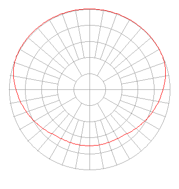 | ||||||||||||||||||
| Azimuth | Ratio | Azimuth | Ratio | Azimuth | Ratio | Azimuth | Ratio | ||||||||||||
| 0 | 1.000 | 10 | 1.000 | 20 | 1.000 | 30 | 1.000 | ||||||||||||
| 40 | 1.000 | 50 | 1.000 | 60 | 0.998 | 70 | 0.988 | ||||||||||||
| 80 | 0.957 | 90 | 0.913 | 100 | 0.872 | 110 | 0.832 | ||||||||||||
| 120 | 0.791 | 130 | 0.755 | 140 | 0.721 | 150 | 0.705 | ||||||||||||
| 160 | 0.701 | 170 | 0.701 | 180 | 0.701 | 190 | 0.701 | ||||||||||||
| 200 | 0.701 | 210 | 0.705 | 220 | 0.721 | 230 | 0.755 | ||||||||||||
| 240 | 0.791 | 250 | 0.832 | 260 | 0.872 | 270 | 0.913 | ||||||||||||
| 280 | 0.957 | 290 | 0.988 | 300 | 0.998 | 310 | 1.000 | ||||||||||||
| 320 | 1.000 | 330 | 1.000 | 340 | 1.000 | 350 | 1.000 | ||||||||||||
Structure Registration Number 1020405 [ASR Heights Differ from W247CJ Application] Structure Type: LTOWER Registered To: Diverse Power Incorporated Structure Address: Hwy 190 .5 Mi W Of Ga 85e Manchester, GA County Name: Talbot County ASR Issued: 02/27/2017 Date Built: 01/01/1984 Site Elevation: 355 m (1165 ft.) Structure Height: 100.5 m (330 ft.) Height Overall: 100.5 m (330 ft.) Overall Height AMSL: 455.5 m (1494 ft.) FAA Determination: 12/01/2015 FAA Study #: 2015-ASO-18670-OE FAA Circular #: 70/7460-1K Paint & Light FAA Chapters: 4, 6, 12 PRIOR STUDIES 1982-ASO-803-OE / 2012-ASO-651-OE 32-50-40.0 N 84-37-25.0 W (NAD 83) 32-50-39.5 N 84-37-25.3 W (Converted to NAD 27) |
6174 Highway 57 Macon, GA 31217 Phone: 404-307-8079 Limited Liability Company | Date: 08/29/2016 Application Certifier EDGEWATER BROADCASTING, INC. 160 W Gooding Street Twin Falls, ID 83301 Applicant GENE WISNIEWSKI 160 Gooding Street West Suite A Twin Falls, ID 83301 CONSULTING ENGINEER CLARK PARRISH Edgewater Broadcasting, Inc. 160 W Gooding Street Twin Falls, ID 83301 | |||||||||||||||||