
FCCInfo.com
A Service of Cavell, Mertz & Associates, Inc.
(855) FCC-INFO
|
|
WPPR from 04/01/1996 |
|
|
||||||||||||||||
|
|
WPPR Channel: 202C2 88.3 MHz Demorest, Georgia Service: FM - A full-service FM station or application. Facility ID: 23949 Fac. Service: FM Analog & Digital Status: License Application Accepted: 04/28/2008 Application Granted: 05/28/2008 File Number: BLED-20080428ABF License Expires: 00/00/0000 Prefix Type: This is a license for a noncommercial educational FM station Application Type: License To Cover FCC Website Links: LMS Facility Details This Application CDBS Application Other WPPR Applications Other WPPR Applications in CDBS Including Superseded Applications Mailing Address Correspondence for WPPR Correspondence related to application BLED-20080428ABF Service Contour - Open Street Map or USGS Map (60 dBu) Service Contour - KML / Google Earth (60 dBu) Public Inspection Files Facility Type: NON-COMMERCIAL EDUC. FM Class: C2, A Zone II station; with 25kW-50kW ERP and a class contour distance 39km-52km Site Location: 34-31-24.4 N 83-40-45.6 W (NAD 83) Site Location: 34-31-24.0 N 83-40-46.0 W (Converted to NAD 27) Effective Radiated Power: 7.3 kW Transmitter Output Power: 5.89 kW Antenna Center HAAT: 193.9 m (636 ft.) Antenna Center AMSL: 610.7 m (2004 ft.) Antenna Center HAG: 183 m (600 ft.) Site Elevation: 427.7 m. (1403 ft.) Height Overall*: 244.8 m (803 ft.) (* As Filed In This Application, may differ from ASR Data, Below.) Directional Antenna Antenna Make/Model: Jampro JMPC-1R Antenna ID: 76828 Polarization: | ||||||||||||||||||
| Antenna Data for Antenna Id: 76828 WPPR FM File: BLED-20080428ABF Jampro - JMPC-1R Service: FM | 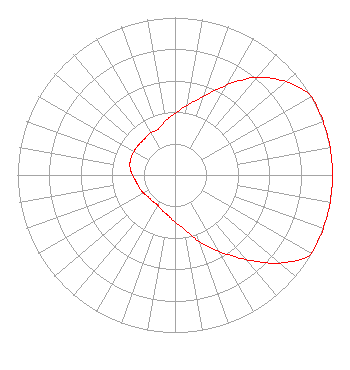 | ||||||||||||||||||
| Azimuth | Ratio | Azimuth | Ratio | Azimuth | Ratio | Azimuth | Ratio | ||||||||||||
| 0 | 0.390 | 10 | 0.450 | 20 | 0.530 | 30 | 0.660 | ||||||||||||
| 40 | 0.810 | 50 | 0.920 | 60 | 1.000 | 70 | 1.000 | ||||||||||||
| 80 | 1.000 | 90 | 1.000 | 100 | 1.000 | 110 | 1.000 | ||||||||||||
| 120 | 1.000 | 130 | 0.870 | 140 | 0.700 | 150 | 0.560 | ||||||||||||
| 160 | 0.450 | 170 | 0.350 | 180 | 0.300 | 190 | 0.260 | ||||||||||||
| 200 | 0.240 | 210 | 0.220 | 220 | 0.220 | 230 | 0.220 | ||||||||||||
| 240 | 0.230 | 250 | 0.240 | 260 | 0.250 | 270 | 0.270 | ||||||||||||
| 280 | 0.290 | 290 | 0.300 | 300 | 0.300 | 310 | 0.300 | ||||||||||||
| 320 | 0.300 | 330 | 0.310 | 340 | 0.310 | 350 | 0.350 | ||||||||||||
Structure Registration Number 1020215 Structure Type: TOWER Registered To: Habersham Broadcasting Company Structure Address: .25 Mi Down Ricky W Rd Leaf, GA County Name: White County ASR Issued: 08/18/2020 Date Built: 11/01/1989 Site Elevation: 427.7 m (1403 ft.) Structure Height: 243.9 m (800 ft.) Height Overall: 244.8 m (803 ft.) Overall Height AMSL: 672.5 m (2206 ft.) FAA Determination: 06/12/1989 FAA Study #: 89-ASO-355-OE FAA Circular #: 70/7460-1G Paint & Light FAA Chapters: 3, 4, 5, 9 RED LIGHTS/PAINT 34-31-24.0 N 83-40-46.0 W (NAD 83) 34-31-23.6 N 83-40-46.4 W (Converted to NAD 27) |
260 14th St Nw Atlanta, GA 30318-5360 Phone: 404-685-2410 Government Entity | Date: 04/28/2008 Application Certifier GEORGIA PUBLIC TELECOMMUNICATIONS COMMISSION 260 Fourteenth Street, N.w. Atlanta, GA 30318 Applicant WILLIAM T. GODFREY, JR. Kessler And Gehman Associates, Inc. 507 Nw 60th Street, Suite C Gainesville, FL 32607-2702 CONSULTING ENGINEER THEODORE D. FRANK Arnold & Porter Llp | |||||||||||||||||