
FCCInfo.com
A Service of Cavell, Mertz & Associates, Inc.
(855) FCC-INFO
|
|
KMKO-FM from 04/01/2005 |
|
|
||||||||||||||||
|
|
KMKO-FM Channel: 239A 95.7 MHz Lake Crystal, Minnesota Service: FM - A full-service FM station or application. Facility ID: 164294 Fac. Service: FM Status: License 73.215 Station Application Accepted: 09/14/2005 Application Granted: 09/19/2005 File Number: BLH-20050914AAE License Expires: 00/00/0000 Prefix Type: This is a license for a commercial FM station Application Type: License To Cover FCC Website Links: LMS Facility Details This Application CDBS Application Other KMKO-FM Applications Other KMKO-FM Applications in CDBS Including Superseded Applications Mailing Address Correspondence for KMKO-FM Correspondence related to application BLH-20050914AAE Service Contour - Open Street Map or USGS Map (60 dBu) Service Contour - KML / Google Earth (60 dBu) Public Inspection Files Facility Type: FM STATION Class: A, A Zone I; I-A; or II station; with 0.1kW-6kW ERP and a class contour distance <=28km Site Location: 44-03-05.9 N 94-17-59.9 W (NAD 83) Site Location: 44-03-06.0 N 94-17-59.0 W (Converted to NAD 27) Effective Radiated Power: 6 kW Transmitter Output Power: 5.9 kW Antenna Center HAAT: 100 m (328 ft.) Antenna Center AMSL: 407.2 m (1336 ft.) Antenna Center HAG: 103.9 m (341 ft.) Calculated Site Elevation: 303.3 m. (995 ft.) Height Overall*: 260.3 m (854 ft.) (* As Filed In This Application, may differ from ASR Data, Below.) Directional Antenna Antenna Make/Model: Electronics Research Inc. LP-2E-DA-HW, 2 sections, 0.5 wavelength spaced Antenna ID: 68623 Polarization:
| ||||||||||||||||||
| Antenna Data for Antenna Id: 68623 KMKO-FM FM File: BLH-20050914AAE Electronics Research Inc. - LP-2E-DA-HW, 2 sections, 0.5 wavelength spaced Service: FM | 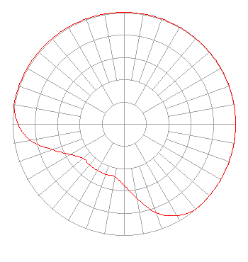 | ||||||||||||||||||
| Azimuth | Ratio | Azimuth | Ratio | Azimuth | Ratio | Azimuth | Ratio | ||||||||||||
| 0 | 1.000 | 10 | 1.000 | 20 | 1.000 | 30 | 1.000 | ||||||||||||
| 40 | 1.000 | 50 | 1.000 | 60 | 1.000 | 70 | 1.000 | ||||||||||||
| 80 | 1.000 | 90 | 1.000 | 100 | 1.000 | 110 | 1.000 | ||||||||||||
| 120 | 1.000 | 130 | 1.000 | 140 | 1.000 | 150 | 0.950 | ||||||||||||
| 160 | 0.850 | 170 | 0.680 | 180 | 0.550 | 190 | 0.480 | ||||||||||||
| 200 | 0.480 | 210 | 0.480 | 220 | 0.480 | 230 | 0.480 | ||||||||||||
| 240 | 0.550 | 250 | 0.680 | 260 | 0.850 | 270 | 0.950 | ||||||||||||
| 280 | 1.000 | 290 | 1.000 | 300 | 1.000 | 310 | 1.000 | ||||||||||||
| 320 | 1.000 | 330 | 1.000 | 340 | 1.000 | 350 | 1.000 | ||||||||||||
Structure Registration Number 1220367 [ASR Heights Differ from KMKO-FM Application] Structure Type: GTOWER Registered To: SBA GC Towers, LLC Structure Address: 49090 174th Street (mn15936-a) Lake Crystal, MN County Name: Blue Earth County ASR Issued: 07/15/2019 Date Built: 05/16/2001 Site Elevation: 310 m (1017 ft.) Structure Height: 259.1 m (850 ft.) Height Overall: 262.1 m (860 ft.) Overall Height AMSL: 572.1 m (1877 ft.) FAA Determination: 07/12/2019 FAA Study #: 2019-AGL-11547-OE FAA Circular #: 70/7460-1L Paint & Light FAA Chapters: 3, 4, 5, 12 PRIOR STUDY 2019-AGL-9840-OE 44-03-05.9 N 94-18-05.2 W (NAD 83) 44-03-06.0 N 94-18-04.3 W (Converted to NAD 27) |
1211 Sw 5th Avenue Suite 750 Portland, OR 97204 Phone: 503-517-6200 Limited Liability Company | Date: 09/14/2005 Application Certifier THREE EAGLES OF LUVERNE, INC. 3800 Cornhusker Highway Lincoln, NE 68504 Applicant ROBERT E. COOK 3800 Cornhusker Hwy Lincoln, NE 68504 TECHNICAL DIRECTOR RICHARD F. SWIFT, ESQUIRE Irwin, Campbell & Tannenwald, P.c. | |||||||||||||||||
| |||||||||||||||||||