
FCCInfo.com
A Service of Cavell, Mertz & Associates, Inc.
(855) FCC-INFO
|
|
WTOP-FM from 10/24/1979 |
|  |
|
|||||||||||||||
|
|
WTOP-FM Channel: 278B 103.5 MHz Washington, District of Columbia Service: FS - A full service FM station auxiliary transmitting antenna or application. Facility ID: 11845 Fac. Service: FM Analog & Digital Status: License Application Accepted: 06/14/2007 Application Granted: 06/22/2007 File Number: BXLH-20070614ABB License Expires: 00/00/0000 Prefix Type: This is BXLH Application Type: License To Cover FCC Website Links: LMS Facility Details This Application CDBS Application Other WTOP-FM Applications Other WTOP-FM Applications in CDBS Including Superseded Applications Mailing Address Correspondence for WTOP-FM Correspondence related to application BXLH-20070614ABB Service Contour - Open Street Map or USGS Map (54 dBu) Service Contour - KML / Google Earth (54 dBu) Public Inspection Files History Cards for WTOP-FM Facility Type: FM STATION Class: B, A Zone I or I-A station; with 25kW-50kW ERP and a class contour distance 39km-52km Site Location: 39-02-32.0 N 77-02-48.0 W (NAD 83) Site Location: 39-02-31.6 N 77-02-49.1 W (Converted to NAD 27) Effective Radiated Power: 44 kW Transmitter Output Power: 26 kW Antenna Center HAAT: 138 m (453 ft.) Antenna Center AMSL: 224 m (735 ft.) Antenna Center HAG: 98 m (322 ft.) Calculated Site Elevation: 126 m. (413 ft.) Height Overall*: 108 m (354 ft.) (* As Filed In This Application, may differ from ASR Data, Below.) Directional Antenna Antenna Make/Model: SHV 6810-3R-SS-DA, three sections Antenna ID: 70940 Polarization:
| ||||||||||||||||||
| Antenna Data for Antenna Id: 70940 WTOP-FM FS File: BXLH-20070614ABB SHV - 6810-3R-SS-DA, three sections Service: FS | 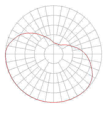 | ||||||||||||||||||
| Azimuth | Ratio | Azimuth | Ratio | Azimuth | Ratio | Azimuth | Ratio | ||||||||||||
| 0 | 0.240 | 10 | 0.220 | 20 | 0.220 | 30 | 0.220 | ||||||||||||
| 40 | 0.240 | 50 | 0.290 | 60 | 0.360 | 70 | 0.440 | ||||||||||||
| 80 | 0.550 | 90 | 0.660 | 100 | 0.750 | 110 | 0.840 | ||||||||||||
| 120 | 0.930 | 130 | 0.980 | 140 | 1.000 | 150 | 1.000 | ||||||||||||
| 160 | 1.000 | 170 | 1.000 | 180 | 1.000 | 190 | 1.000 | ||||||||||||
| 200 | 1.000 | 210 | 1.000 | 220 | 1.000 | 230 | 1.000 | ||||||||||||
| 240 | 1.000 | 250 | 1.000 | 260 | 1.000 | 270 | 1.000 | ||||||||||||
| 280 | 0.960 | 290 | 0.880 | 300 | 0.790 | 310 | 0.670 | ||||||||||||
| 320 | 0.540 | 330 | 0.430 | 340 | 0.350 | 350 | 0.290 | ||||||||||||
Structure Registration Number 1053549 Structure Type: Registered To: Hubbard Radio Washington DC, LLC Structure Address: Twr 1 - 2021 University Blvd. West Wheaton, MD County Name: Montgomery County ASR Issued: 02/24/2023 Date Built: 09/01/1939 Site Elevation: 126.5 m (415 ft.) Structure Height: 106.6 m (350 ft.) Height Overall: 108.1 m (355 ft.) Overall Height AMSL: 234.6 m (770 ft.) FAA Determination: 02/11/1998 FAA Study #: 97-AEA-4077-OE FAA Circular #: 70/7460-1J Paint & Light FAA Chapters: 3, 4, 5, 13 39-02-32.0 N 77-02-48.0 W (NAD 83) 39-02-31.6 N 77-02-49.1 W (Converted to NAD 27) |
3415 University Avenue, West St. Paul, MN 55114 Phone: 651-642-4336 Limited Liability Company | Date: 06/14/2007 Application Certifier BONNEVILLE HOLDING COMPANY 55 North 300 West 8th Floor Salt Lake City, UT 84180 Applicant JAMES TALMAGE BALL Bonneville International Corp 55 North 300 West Salt Lake City, UT 84180 VP ENGINEERING BONNEVILLE INTERNATIONAL KENNETH E. SATTEN Wilkinson Barker Knauer, Llp | |||||||||||||||||
| |||||||||||||||||||