
FCCInfo.com
A Service of Cavell, Mertz & Associates, Inc.
(855) FCC-INFO
|
|
|
|
|
||||||||||||||||
|
|
K258CG Channel: 258D 99.5 MHz Rifle, Colorado Service: FX - A translator or application for a translator. Facility ID: 12377 Fac. Service: FX Programming Delivery Method: Unspecified Status: License Application Accepted: 07/01/2013 Application Granted: 07/24/2013 File Number: BLFT-20130701AAK License Expires: 00/00/0000 Prefix Type: This is a license for a translator Application Type: License To Cover FCC Website Links: LMS Facility Details This Application CDBS Application Other K258CG Applications Other K258CG Applications in CDBS Including Superseded Applications Mailing Address Correspondence for K258CG Correspondence related to application BLFT-20130701AAK Service Contour - Open Street Map or USGS Map (60 dBu) Service Contour - KML / Google Earth (60 dBu) Class: D, A Noncommercial educational operating with no more than 10W Site Location: 39-30-49.9 N 107-44-54.2 W (NAD 83) Site Location: 39-30-50.0 N 107-44-52.0 W (Converted to NAD 27) Effective Radiated Power: 0.02 kW Transmitter Output Power: 0.048 kW Antenna Center HAAT: -49.9 m Horiz.; 0 m Vert. Antenna Center AMSL: 1882 m (6175 ft.) Antenna Center HAG: 8 m (26 ft.) Site Elevation: 1874 m. (6148 ft.) Height Overall*: 21 m (69 ft.) (* As Filed In This Application, may differ from ASR Data, Below.) Directional Antenna Antenna Make/Model: None Antenna ID: 112593 Polarization:
| ||||||||||||||||||
| Antenna Data for Antenna Id: 112593 K258CG FX File: BLFT-20130701AAK None - Service: FX | 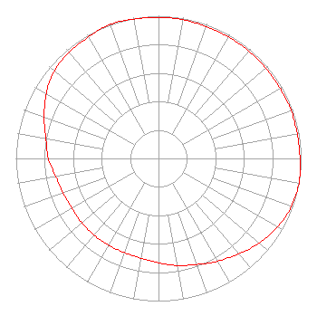 | ||||||||||||||||||
| Azimuth | Ratio | Azimuth | Ratio | Azimuth | Ratio | Azimuth | Ratio | ||||||||||||
| 0 | 0.988 | 10 | 0.988 | 20 | 0.983 | 30 | 0.983 | ||||||||||||
| 40 | 0.983 | 50 | 0.983 | 60 | 0.983 | 70 | 0.988 | ||||||||||||
| 80 | 0.988 | 90 | 0.992 | 100 | 1.000 | 110 | 0.991 | ||||||||||||
| 120 | 0.963 | 130 | 0.923 | 140 | 0.873 | 150 | 0.832 | ||||||||||||
| 160 | 0.792 | 170 | 0.762 | 180 | 0.732 | 190 | 0.710 | ||||||||||||
| 200 | 0.702 | 210 | 0.702 | 220 | 0.702 | 230 | 0.702 | ||||||||||||
| 240 | 0.702 | 250 | 0.712 | 260 | 0.732 | 270 | 0.772 | ||||||||||||
| 280 | 0.802 | 290 | 0.853 | 300 | 0.909 | 310 | 0.953 | ||||||||||||
| 320 | 0.973 | 330 | 0.983 | 340 | 1.000 | 350 | 0.992 | ||||||||||||
Structure Registration Number 1254241 Structure Type: TOWER Registered To: Colorado West Broadcasting, Inc Structure Address: 2.3 Miles Se Of Rifle Co At The Ne Edge Of The Top Of Grass Mesa Rifle, CO County Name: Garfield County ASR Issued: 01/19/2022 Date Built: 05/21/2008 Site Elevation: 1874.2 m (6149 ft.) Structure Height: 21.3 m (70 ft.) Height Overall: 21.3 m (70 ft.) Overall Height AMSL: 1895.5 m (6219 ft.) FAA Determination: 01/11/2008 FAA Study #: 2007-ANM-3904-OE Paint & Light FAA Chapters: NONE Removed expiration and final dates from determination. Scenario 2./jjs/case#635066 39-30-49.5 N 107-44-54.5 W (NAD 83) 39-30-49.6 N 107-44-52.3 W (Converted to NAD 27) |
P.o. Box 1028 Glenwood Springs, CO 81602 Phone: 970-945-9124 Corporation | Date: 07/01/2013 Application Certifier COLORADO WEST BROADCASTING, INCORPORATED 3230-b South Glen Avenue Glenwood Springs, CO 81601 Applicant JON V BANKS 1015 Park West Drive Glenwood Springs, CO 81601 TECHNICAL CONSULTANT COLORADO WEST BROADCASTING, INCORPORATED Colorado West Broadcasting, Incorporated 3230-b South Glen Avenue Glenwood Springs, CO 81601 | |||||||||||||||||