
FCCInfo.com
A Service of Cavell, Mertz & Associates, Inc.
(855) FCC-INFO
|
|
WRVZ from 11/21/1994 WRVZ from 06/01/1994 WRVZ from 10/31/1989 |
|
|
||||||||||||||||
|
|
WCST-FM Channel: 254A 98.7 MHz Pocatalico, West Virginia Service: FM - A full-service FM station or application. Facility ID: 71433 Fac. Service: FM Status: License 73.215 Station Application Accepted: 06/20/1996 Application Granted: 05/26/1998 File Number: BLH-19960620KA License Expires: 00/00/0000 Prefix Type: This is a license for a commercial FM station Application Type: License To Cover FCC Website Links: LMS Facility Details This Application CDBS Application Other WCST-FM Applications Other WCST-FM Applications in CDBS Including Superseded Applications Mailing Address Correspondence for WCST-FM Correspondence related to application BLH-19960620KA Service Contour - Open Street Map or USGS Map (60 dBu) Service Contour - KML / Google Earth (60 dBu) Public Inspection Files Facility Type: FM STATION Class: A, A Zone I; I-A; or II station; with 0.1kW-6kW ERP and a class contour distance <=28km Site Location: 38-23-53.3 N 81-41-05.5 W (NAD 83) Site Location: 38-23-53.0 N 81-41-06.0 W (Converted to NAD 27) Effective Radiated Power: 0.63 kW Antenna Center HAAT: 188 m (617 ft.) Antenna Center AMSL: 434 m (1424 ft.) Antenna Center HAG: 90 m (295 ft.) Calculated Site Elevation: 344 m. (1129 ft.) Height Overall*: 93 m (305 ft.) (* As Filed In This Application, may differ from ASR Data, Below.) Directional Antenna Antenna Make/Model: Oddball; usually designed by Applicant ODD960821ID Antenna ID: 15046 Polarization: | ||||||||||||||||||
| Antenna Data for Antenna Id: 15046 WCST-FM FM File: BLH-19960620KA Oddball; usually designed by Applicant - ODD960821ID Service: FM | 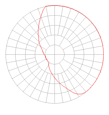 | ||||||||||||||||||
| Azimuth | Ratio | Azimuth | Ratio | Azimuth | Ratio | Azimuth | Ratio | ||||||||||||
| 0 | 1.000 | 10 | 1.000 | 20 | 1.000 | 30 | 1.000 | ||||||||||||
| 40 | 1.000 | 50 | 1.000 | 60 | 1.000 | 70 | 1.000 | ||||||||||||
| 80 | 1.000 | 90 | 1.000 | 100 | 1.000 | 110 | 1.000 | ||||||||||||
| 120 | 1.000 | 130 | 1.000 | 140 | 1.000 | 150 | 0.935 | ||||||||||||
| 160 | 0.745 | 170 | 0.595 | 180 | 0.475 | 190 | 0.380 | ||||||||||||
| 200 | 0.305 | 210 | 0.245 | 220 | 0.200 | 225 | 0.195 | ||||||||||||
| 230 | 0.190 | 240 | 0.190 | 250 | 0.190 | 260 | 0.190 | ||||||||||||
| 270 | 0.214 | 280 | 0.235 | 290 | 0.267 | 300 | 0.330 | ||||||||||||
| 310 | 0.415 | 315 | 0.455 | 320 | 0.520 | 330 | 0.650 | ||||||||||||
| 340 | 0.815 | 350 | 1.000 | ||||||||||||||||
Structure Registration Number 1036503 Structure Type: TOWER Registered To: West Virginia Radio Corporation of Charleston Structure Address: Wildwood Acres Tyler Mountain Guthrie, WV County Name: Kanawha County ASR Issued: 05/09/2001 Date Built: 04/01/1996 Site Elevation: 344.1 m (1129 ft.) Structure Height: 92.6 m (304 ft.) Height Overall: 92.6 m (304 ft.) Overall Height AMSL: 436.7 m (1433 ft.) FAA Determination: 10/05/1995 FAA Study #: 95-AEA-1405-OE FAA Circular #: 70/7460-1H Paint & Light FAA Chapters: 3, 4, 5, 13 38-23-53.0 N 81-41-05.0 W (NAD 83) 38-23-52.7 N 81-41-05.5 W (Converted to NAD 27) |
1251 Earl L. Core Road Morgantown, WV 26505-5896 Phone: 304-296-0029 | Date: 06/20/1996 Application Certifier WEIGLE BROADCASTING CORPORATION Weigle Broadcasting Corporation 1235 Fletcher Ave Dunbar, WV 25301 Applicant | |||||||||||||||||
| |||||||||||||||||||