
FCCInfo.com
A Service of Cavell, Mertz & Associates, Inc.
(855) FCC-INFO
|
|
WSBB-FM from 10/21/1999 WSBB-FM from 10/08/1999 WSBB-FM from 12/01/1978 |
|  |
|
|||||||||||||||
|
|
WSBB-FM Channel: 238C1 95.5 MHz Doraville, Georgia Service: FM - A full-service FM station or application. Facility ID: 11710 Fac. Service: FM Analog & Digital Status: License 73.215 Station Application Accepted: 08/02/2019 Application Granted: 09/20/2019 File Number: BLH-20190802ABE License Expires: 00/00/0000 Prefix Type: This is a license for a commercial FM station Application Type: License To Cover FCC Website Links: LMS Facility Details This Application CDBS Application Other WSBB-FM Applications Other WSBB-FM Applications in CDBS Including Superseded Applications Mailing Address Correspondence for WSBB-FM Correspondence related to application BLH-20190802ABE Service Contour - Open Street Map or USGS Map (60 dBu) Service Contour - KML / Google Earth (60 dBu) Public Inspection Files History Cards for WSBB-FM Facility Type: FM STATION Class: C1, A Zone II station; with 50kW-100kW ERP and a class contour distance 52km-72km Site Location: 33-45-33.4 N 84-20-04.7 W (NAD 83) Site Location: 33-45-33.0 N 84-20-05.0 W (Converted to NAD 27) Effective Radiated Power: 100 kW Transmitter Output Power: 25 kW Antenna Center HAAT: 279 m (915 ft.) Antenna Center AMSL: 560 m (1837 ft.) Antenna Center HAG: 258 m (846 ft.) Calculated Site Elevation: 302 m. (991 ft.) Height Overall*: 324 m (1063 ft.) (* As Filed In This Application, may differ from ASR Data, Below.) Directional Antenna Antenna Make/Model: Electronics Research Inc. 1193-6CP-DA, 6 sections Antenna ID: 131935 Polarization: | ||||||||||||||||||
| Antenna Data for Antenna Id: 131935 WSBB-FM FM File: BLH-20190802ABE Electronics Research Inc. - 1193-6CP-DA, 6 sections Service: FM | 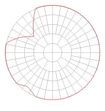 | ||||||||||||||||||
| Azimuth | Ratio | Azimuth | Ratio | Azimuth | Ratio | Azimuth | Ratio | ||||||||||||
| 0 | 1.000 | 10 | 1.000 | 20 | 1.000 | 30 | 1.000 | ||||||||||||
| 40 | 1.000 | 50 | 1.000 | 60 | 1.000 | 70 | 1.000 | ||||||||||||
| 80 | 1.000 | 90 | 1.000 | 100 | 1.000 | 110 | 1.000 | ||||||||||||
| 120 | 1.000 | 130 | 1.000 | 140 | 1.000 | 150 | 1.000 | ||||||||||||
| 160 | 1.000 | 170 | 1.000 | 180 | 1.000 | 190 | 1.000 | ||||||||||||
| 200 | 1.000 | 210 | 0.925 | 217 | 0.900 | 220 | 0.925 | ||||||||||||
| 230 | 1.000 | 240 | 1.000 | 250 | 1.000 | 260 | 1.000 | ||||||||||||
| 270 | 1.000 | 280 | 1.000 | 290 | 0.839 | 300 | 0.667 | ||||||||||||
| 310 | 0.530 | 315 | 0.570 | 320 | 0.639 | 330 | 0.800 | ||||||||||||
| 340 | 1.000 | 350 | 1.000 | ||||||||||||||||
Structure Registration Number 1028278 Structure Type: GTOWER Registered To: Board of Education of the City of Atlanta Structure Address: 1610 New Street Atlanta, GA County Name: DeKalb County ASR Issued: 05/25/2021 Date Built: 10/01/1986 Site Elevation: 301.8 m (990 ft.) Structure Height: 306.1 m (1004 ft.) Height Overall: 323.8 m (1062 ft.) Overall Height AMSL: 625.6 m (2052 ft.) FAA Determination: 05/24/2021 FAA Study #: 2021-ASO-19270-OE FAA Circular #: 70/7460-1M Paint & Light FAA Chapters: 4, 7, 15 PRIOR STUDY 1997-ASO-2288-OE 33-45-33.0 N 84-20-05.0 W (NAD 83) 33-45-32.6 N 84-20-05.3 W (Converted to NAD 27) |
1601 W Peachtree Street Ne Atlanta, GA 30309 Phone: 404-897-7000 Limited Liability Company | Date: 08/02/2019 Application Certifier COX RADIO, INC. 1601 West Peachtree Street, N.e. Atlanta, GA 30309 Applicant WILLIAM JEFFREY REYNOLDS Du Treil, Lundin & Rackley, Inc. 3135 Southgate Circle Sarasota, FL 34239-5515 TECHNICAL CONSULTANT JOHN S. LOGAN Cooley Llp | |||||||||||||||||
| |||||||||||||||||||