
FCCInfo.com
A Service of Cavell, Mertz & Associates, Inc.
(855) FCC-INFO
|
|
|
|
|
||||||||||||||||
|
|
KJOY Channel: 257A 99.3 MHz Stockton, California Service: FM - A full-service FM station or application. Facility ID: 32215 Fac. Service: FM Status: License 73.215 Station Application Accepted: 05/09/2000 Application Granted: 06/05/2000 File Number: BLH-20000509AAA License Expires: 00/00/0000 Prefix Type: This is a license for a commercial FM station Application Type: License To Cover FCC Website Links: LMS Facility Details This Application CDBS Application Other KJOY Applications Other KJOY Applications in CDBS Including Superseded Applications Mailing Address Correspondence for KJOY Correspondence related to application BLH-20000509AAA Service Contour - Open Street Map or USGS Map (60 dBu) Service Contour - KML / Google Earth (60 dBu) Public Inspection Files History Cards for KJOY Facility Type: FM STATION Class: A, A Zone I; I-A; or II station; with 0.1kW-6kW ERP and a class contour distance <=28km Site Location: 37-59-29.7 N 121-17-20.8 W (NAD 83) Site Location: 37-59-30.0 N 121-17-17.0 W (Converted to NAD 27) Effective Radiated Power: 4 kW Transmitter Output Power: 2.6 kW Antenna Center HAAT: 98 m (322 ft.) Antenna Center AMSL: 130 m (427 ft.) Antenna Center HAG: 124 m (407 ft.) Site Elevation: 6 m. (20 ft.) Height Overall*: 128 m (420 ft.) (* As Filed In This Application, may differ from ASR Data, Below.) Directional Antenna Antenna Make/Model: Jampro JMPC-3 RFR DA Antenna ID: 30698 Polarization: | ||||||||||||||||||
| Antenna Data for Antenna Id: 30698 KJOY FM File: BLH-20000509AAA Jampro - JMPC-3 RFR DA Service: FM | 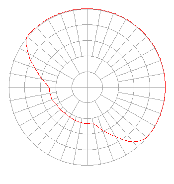 | ||||||||||||||||||
| Azimuth | Ratio | Azimuth | Ratio | Azimuth | Ratio | Azimuth | Ratio | ||||||||||||
| 0 | 1.000 | 10 | 1.000 | 20 | 1.000 | 30 | 1.000 | ||||||||||||
| 40 | 1.000 | 50 | 1.000 | 60 | 1.000 | 70 | 1.000 | ||||||||||||
| 80 | 1.000 | 90 | 1.000 | 100 | 1.000 | 110 | 1.000 | ||||||||||||
| 120 | 1.000 | 130 | 1.000 | 140 | 0.912 | 150 | 0.733 | ||||||||||||
| 160 | 0.589 | 170 | 0.473 | 180 | 0.468 | 190 | 0.459 | ||||||||||||
| 200 | 0.452 | 210 | 0.442 | 220 | 0.437 | 230 | 0.447 | ||||||||||||
| 240 | 0.447 | 250 | 0.473 | 260 | 0.479 | 270 | 0.490 | ||||||||||||
| 280 | 0.582 | 290 | 0.708 | 300 | 0.871 | 310 | 1.000 | ||||||||||||
| 320 | 1.000 | 330 | 1.000 | 340 | 1.000 | 350 | 1.000 | ||||||||||||
Structure Registration Number 1016801 [ASR Heights Differ from KJOY Application] Structure Type: LTOWER Registered To: SBA Towers IV, LLC Structure Address: 4210 Coronado Ave (ca15247-a) Stockton, CA County Name: San Joaquin County ASR Issued: 10/09/2023 Date Built: 01/01/1994 Site Elevation: 6.7 m (22 ft.) Structure Height: 122.5 m (402 ft.) Height Overall: 132 m (433 ft.) Overall Height AMSL: 138.7 m (455 ft.) FAA Determination: 10/02/2023 FAA Study #: 2023-AWP-15370-OE FAA Circular #: 70/7460-1M Paint & Light FAA Chapters: 4, 8, 15 PRIOR STUDY 2013-AWP-234-OE 37-59-30.2 N 121-17-18.8 W (NAD 83) 37-59-30.5 N 121-17-15.0 W (Converted to NAD 27) |
780 Johnson Ferry Road Suite 500 Atlanta, GA 30342 Phone: 404-949-0700 Limited Liability Company | Date: 05/09/2000 Application Certifier SILVERADO BROADCASTING COMPANY Silverado Broadcasting Company 6820 Pacific Ave. Suite 2 Stockton, CA 95207 Applicant CONSULTING ENGINEER | |||||||||||||||||
| |||||||||||||||||||