
FCCInfo.com
A Service of Cavell, Mertz & Associates, Inc.
(855) FCC-INFO
|
|
W248CE from 10/30/2013 |
|
|
||||||||||||||||
|
|
W248CE Channel: 248D 97.5 MHz Gadsden, Alabama Service: FX - A translator or application for a translator. Facility ID: 141190 Fac. Service: FX Programming Delivery Method: Unspecified Status: License Application Accepted: 12/29/2014 Application Granted: 01/20/2015 File Number: BLFT-20141229AWC License Expires: 00/00/0000 Prefix Type: This is a license for a translator Application Type: License To Cover FCC Website Links: LMS Facility Details This Application CDBS Application Other W248CE Applications Other W248CE Applications in CDBS Including Superseded Applications Mailing Address Correspondence for W248CE Correspondence related to application BLFT-20141229AWC Service Contour - Open Street Map or USGS Map (60 dBu) Service Contour - KML / Google Earth (60 dBu) Class: D, A Noncommercial educational operating with no more than 10W Site Location: 34-02-14.3 N 85-59-59.9 W (NAD 83) Site Location: 34-02-14.0 N 86-00-00.0 W (Converted to NAD 27) Effective Radiated Power: 0.25 kW Transmitter Output Power: 0.076 kW Antenna Center HAAT: 0 m Antenna Center AMSL: 393 m (1289 ft.) Antenna Center HAG: 60 m (197 ft.) Site Elevation: 333 m. (1093 ft.) Height Overall*: 97 m (318 ft.) (* As Filed In This Application, may differ from ASR Data, Below.) Directional Antenna Antenna Make/Model: None Antenna ID: 16149 Polarization:
| ||||||||||||||||||
| Antenna Data for Antenna Id: 16149 W248CE FX File: BLFT-20141229AWC None - Service: FX Pattern and Field Values Include a 200° Clockwise Rotation | 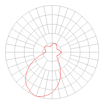 | ||||||||||||||||||
| Azimuth | Ratio | Azimuth | Ratio | Azimuth | Ratio | Azimuth | Ratio | ||||||||||||
| 0 | 0.160 | 10 | 0.182 | 20 | 0.193 | 30 | 0.182 | ||||||||||||
| 40 | 0.160 | 50 | 0.135 | 60 | 0.123 | 70 | 0.140 | ||||||||||||
| 80 | 0.171 | 90 | 0.187 | 100 | 0.181 | 110 | 0.157 | ||||||||||||
| 120 | 0.142 | 130 | 0.134 | 140 | 0.190 | 150 | 0.329 | ||||||||||||
| 160 | 0.528 | 170 | 0.718 | 180 | 0.866 | 190 | 0.952 | ||||||||||||
| 200 | 1.000 | 210 | 0.952 | 220 | 0.866 | 230 | 0.718 | ||||||||||||
| 240 | 0.528 | 250 | 0.329 | 260 | 0.190 | 270 | 0.134 | ||||||||||||
| 280 | 0.142 | 290 | 0.157 | 300 | 0.181 | 310 | 0.187 | ||||||||||||
| 320 | 0.171 | 330 | 0.140 | 340 | 0.123 | 350 | 0.135 | ||||||||||||
Structure Registration Number 1202286 Structure Type: TOWER Registered To: McCord Communication Service Inc Structure Address: 700 Overlook Dr. Gadsden, AL County Name: Etowah County ASR Issued: 08/31/1999 Site Elevation: 333 m (1093 ft.) Structure Height: 97 m (318 ft.) Height Overall: 97 m (318 ft.) Overall Height AMSL: 430 m (1411 ft.) FAA Determination: 03/25/1987 FAA Study #: 86-ASO-3024-OE FAA Circular #: 70/7460-1G Paint & Light FAA Chapters: 4, 6, 9 MED INT WHITE LIGHTS. 34-02-14.0 N 86-00-00.0 W (NAD 83) 34-02-13.6 N 86-00-00.1 W (Converted to NAD 27) |
P. O. Box 2552 Anniston, AL 36202 Phone: 256-236-1274 | Date: 12/29/2014 Application Certifier SHELBY BROADCAST ASSOCIATES, LLC 5256 Valleybrook Trace Birmingham, AL 35244 Applicant LEE S. REYNOLDS 5256 Valleybrook Trace Birmingham, AL 35244 TECHNICAL CONSULTANT LEE REYNOLDS Lee Reynolds 5256 Valleybrook Trace Birmingham, AL 35244 | |||||||||||||||||